Brooks is a city in southeast Alberta, Canada, surrounded by the County of Newell. It is located on Highway 1 and the Canadian Pacific Railway, approximately 186 km (116 mi) southeast of Calgary, and 110 km (68 mi) northwest of Medicine Hat. The city has an elevation of 760 m (2,490 ft).

Ohaton is a hamlet in central Alberta, Canada within Camrose County. Previously an incorporated municipality, Ohaton dissolved from village status on January 1, 1946.

Rocky View County is a municipal district in southern Alberta, Canada that is named for its views of the nearby Rocky Mountains to the west. It surrounds most of Calgary, forming the city's northern boundary and most of the city's western and eastern boundaries. At a population of 39,407 in 2016, Rocky View County is the most populous municipal district in Alberta. Though predominantly rural in nature, Rocky View County is home to 14 hamlets, including Langdon, one of Alberta's most populous hamlets. Its rural areas are home to numerous country residential subdivisions.

The County of Grande Prairie No. 1 is a municipal district in northwestern Alberta, Canada in Census Division No. 19.

Division No. 1 is a census division in Alberta, Canada. It is located in the southeast corner of southern Alberta and surrounds the City of Medicine Hat.

High Prairie is a town in northern Alberta, Canada within Big Lakes County. It is located at the junction of Highway 2 and Highway 749, approximately 89 km (55 mi) northeast of Valleyview and 118 km (73 mi) west of Slave Lake.

McLennan is a town in northern Alberta, southwestern inland Canada. It is located 50 km (31 mi) north of High Prairie on Highway 2.
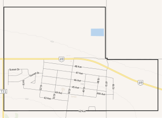
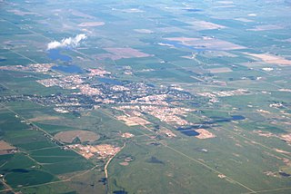
Spirit River is a town in northern Alberta, Canada. It is located 78 km (48 mi) north of Grande Prairie at the junction of Highway 49 and Highway 731.
Wembley is a town in northern Alberta, Canada. It is located approximately 23 km (14 mi) west of Grande Prairie at the junction of Highway 43 and Highway 724.

Hythe is a village surrounded by the County of Grande Prairie No. 1 in northwestern Alberta, Canada. It is located on Highway 43 approximately 58 km (36 mi) northwest of the City of Grande Prairie and 73 km (45 mi) southeast of the City of Dawson Creek, British Columbia.
Richdale is a hamlet in east-central Alberta, Canada within Special Area No. 2. It is located on Highway 9 approximately 24 kilometres (15 mi) east of the Town of Hanna, 29 kilometres (18 mi) west of the Village of Youngstown and 130 kilometres (81 mi) north of the City of Brooks. Previously an incorporated community, Richdale dissolved from village status on June 2, 1931.
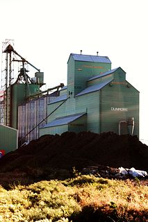
Dunmore is a hamlet in Alberta, Canada within Cypress County, located 2.6 kilometres (1.6 mi) southeast of Medicine Hat's city limits on Highway 1 and the Canadian Pacific Railway mainline. A portion of the hamlet is recognized as a designated place by Statistics Canada.

Maple Creek is a town in the Cypress Hills of southwest Saskatchewan, Canada. It is surrounded by the Rural Municipality of Maple Creek No. 111. The population was 2,084 at the 2016 Census.

Cypress County is a municipal district in southeastern Alberta, Canada. The County completely surrounds the City of Medicine Hat and the Town of Redcliff. The municipality is part of Census Division 1, Alberta. The first farm in the area was settled in 1890.

Mackenzie County is a specialized municipality in northern Alberta, Canada. It is located in Census Division 17, along the Mackenzie Highway. Incorporated as a municipal district in 1995 from the former Improvement District No. 23., its status was changed to specialized municipality in 1999 to address the particularities of managing such a large territory, which is 10% larger than New Brunswick. Mackenzie County municipal office is located in the Hamlet of Fort Vermilion. The name was changed from the Municipal District of Mackenzie No. 23 to Mackenzie County in 2007.

The County of Northern Lights is a municipal district in northwest Alberta, Canada. Located in Census Division 17, its municipal office is located in the Town of Manning.

The Municipal District of Spirit River No. 133 is a municipal district (MD) in northwest Alberta, Canada, north of Grande Prairie. Located in the Upper Peace Region, its municipal office is located in the Town of Spirit River. With an area of 683.6 km2 (263.9 sq mi), it is the smallest municipal district in Alberta.

The Rural Municipality of Reno No. 51 is a rural municipality (RM) in the Canadian province of Saskatchewan within Census Division No. 4 and SARM Division No. 3. Located in the southwest corner of the province, it is adjacent to the United States border to the south and the Alberta boundary to the west.
Veinerville is a hamlet in southern Alberta, Canada within Cypress County. It is located 0.5 kilometres (0.31 mi) northwest of Highway 41A, and less than 150 metres (490 ft) from Medicine Hat's east boundary.
Evarts is an unincorporated community in central Alberta, Canada within Red Deer County. It is located on Township Road 382 to the east of the Medicine River, approximately 5.0 km (3.1 mi) south of the Hamlet of Benalto and 13.0 km (8.1 mi) southwest of the Town of Sylvan Lake.

