
An airport is an aerodrome with extended facilities, mostly for commercial air transport. Airports usually consists of a landing area, which comprises an aerially accessible open space including at least one operationally active surface such as a runway for a plane to take off and to land or a helipad, and often includes adjacent utility buildings such as control towers, hangars and terminals, to maintain and monitor aircraft. Larger airports may have airport aprons, taxiway bridges, air traffic control centres, passenger facilities such as restaurants and lounges, and emergency services. In some countries, the US in particular, airports also typically have one or more fixed-base operators, serving general aviation.

According to the International Civil Aviation Organization (ICAO), a runway is a "defined rectangular area on a land aerodrome prepared for the landing and takeoff of aircraft". Runways may be a man-made surface or a natural surface. Runways, as well as taxiways and ramps, are sometimes referred to as "tarmac", though very few runways are built using tarmac. Takeoff and landing areas defined on the surface of water for seaplanes are generally referred to as waterways. Runway lengths are now commonly given in meters worldwide, except in North America where feet are commonly used.

Norwich Airport is an international airport in Hellesdon, Norfolk, England, 2.5 miles (4.0 km) north of Norwich. In 2017, Norwich Airport was the 28th busiest airport in the UK and busiest in the East Anglia region.

Ardmore Airport is an airport 3 nautical miles (5.5 km) southeast of Manurewa in Auckland, New Zealand.

Gan International Airport (GIA) is an international airport located on the island of Gan in Addu Atoll in the island nation of the Maldives. As of June 2019, it is one of three international airports in the Maldives.

Minute Man Air Field is a public-use airport in Stow, Massachusetts, United States. The airport is privately owned by Minute Man Airfield, Inc.

Peterborough Business Airport is a privately owned airfield in the English county of Cambridgeshire near the villages of Holme and Conington, 7 NM south of Peterborough.
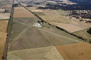
Lake Macquarie Airport is an airfield located in the Lake Macquarie suburb of Marks Point, 15 km (9.3 mi) south of Newcastle, New South Wales, Australia. The airport is located on a narrow peninsula between the Pacific Highway and a shallow tidal inlet that forms the entrance to Lake Macquarie.
Jumbolair Airport is a private-use airport. It is located in the unincorporated community of Anthony, which is seven miles (11 km) northeast of Ocala, Florida, United States. Frank Merschman owned and operated Jumbolair until 2019 when it was sold to Jumbolair Development LLC, managed by Robert and Debra Bull. The airport has two runways: 18/36 with an asphalt pavement measuring 7,550 x 210 ft and 9/27 with a grass surface measuring 3,640 x 100 ft. According to FAA documents, 9/27 ""Greystone"" grass airstrip was once so degraded that only the smallest aircraft could use it.

Bathurst Airport is an airport serving Bathurst, New South Wales, Australia.

Shellharbour Airport, formerly Illawarra Regional Airport, also referred as Albion Park Aerodrome or Wollongong Airport, is an airport located in Albion Park Rail, Shellharbour City, New South Wales, Australia. The Historical Aircraft Restoration Society (HARS) is located at the airport. The airline Link Airways offers daily services from the airport to Melbourne–Essendon and Brisbane.

Sharpe Field is a closed private use airport located six nautical miles northwest of the central business district of Tuskegee, a city in Macon County, Alabama, United States. This airport is privately owned by the Bradbury Family Partnership.

Buckingham Field is a private-use airport located seven nautical miles (13 km) east of the central business district of Fort Myers, in Lee County, Florida, United States. It is privately owned by the Lee County Mosquito Control District. The Buckingham Air Park has deeded access to the airport.

Værnes Air Station is an air station of the Royal Norwegian Air Force located in the municipality of Stjørdal in Trøndelag county, Norway. It is co-located with Trondheim Airport, Værnes, which is owned and operated by Avinor. As an air station, the aerodrome is primarily used for the Marine Corps Preposition Program Norway, which involves the United States armed forces stationing equipment at Værnes and other facilities in the Trondheim region of central Norway. The Værnes military installations contain place for up to six aircraft of the size of a C-5 Galaxy and barracks to house 1,200 soldiers. It also serves the Home Guard, including its training center and the headquarters of the Trøndelag District (HV-12). Formerly, the air force's pilot school was located at Værnes.

Baramati Airport is located in Baramati, Pune district of Maharashtra state in India. This airstrip was constructed by MIDC in 1996, at a distance of 12 km from Baramati city/ Baramati railway station. It is currently being used for general aviation and pilot training.
Lethbridge Airpark is a privately owned aerodrome located 6 km (3.7 mi) north of the rural township of Lethbridge between the regional cities of Geelong 35 km (22 mi) to the south and Ballarat 50 km (31 mi) to the north in Victoria, Australia. The 80 ha site caters to private and recreational pilots, and offers flight training. Current facilities at the airport include several hangars, an aircraft maintenance workshop, and basic amenities including toilets and showers.
Merville – Calonne Airport is a regional airport in France. It is located 3 km south of Merville, in northern France. The airport supports general aviation with no commercial airline service scheduled.
Wedderburn Airstrip is an unlicensed private airfield located in Wedderburn, New South Wales, an outer rural suburb of Sydney, Australia. The airfield caters to recreational aircraft owners and pilots, all of whom are members of the New South Wales Sport Aircraft Club.
Jagodina Airport is situated in the close vicinity of Jagodina, Serbia about 5 kilometres (3.1 mi), northwest of town centre.

Victorville Army Airfield auxiliary fields were four airfields used during World War II to support the Victorville Army Airfield pilot training near Victorville, California, and Adelanto, California. After the war the Victorville Army Airfield was renamed George Air Force Base on January 13, 1948. The airfields were built in 1941 by the United States Army Air Corps just before the war. Victorville Army Airfield covered 2,200-acre in the Mojave Desert. The US Army held a groundbreaking ceremony on 12 July 1941. The base, called Victorville Army Flying School, was ready to use before the attack on Pearl Harbor on December 7, 1941. The Army built four runways in a triangle configuration, with one runway down the middle of the triangle. Seven hangars were built to support operation. On April 23, 1943, the base was renamed Victorville Army Airfield.


