Achaea or Achaia, sometimes transliterated from Greek as Akhaia, is one of the regional units of Greece. It is part of the region of Western Greece and is situated in the northwestern part of the Peloponnese peninsula. The capital is Patras which is the third largest city in Greece.
Farres is a former municipality in Achaea, West Greece, Greece. Since the 2011 local government reform, it is part of the municipality Erymanthos, of which it is a municipal unit. The municipal unit has an area of 241.848 km2. The municipality of Farres existed between 1835 and 1912, and again between 1998 and 2011. Its seat of administration was in the town Chalandritsa. Farres is situated in the centre of Achaea, on the upper courses of the rivers Peiros and Parapeiros. Towards the southeast and northeast (Panachaiko) the terrain is increasingly mountainous. It is located about 15 km south of Patras and 30 km west of Kalavryta. The Greek National Road 33 runs through western Farres.

Kalavryta is a town and a municipality in the mountainous east-central part of the regional unit of Achaea, Greece. The town is located on the right bank of the river Vouraikos, 24 kilometres south of Aigio, 40 km southeast of Patras and 62 km northwest of Tripoli. Notable mountains in the municipality are Mount Erymanthos in the west and Aroania or Chelmos in the southeast. Kalavryta is the southern terminus of the Diakopto-Kalavryta rack railway, built by Italian engineers between 1885 and 1895.

Chalandritsa is a town and a community in Achaea, West Greece, Greece. Since 2011 local government reform it is part of the municipality Erymanthos, of which it is the seat of administration. Chalandritsa is situated in hills north of the river Peiros, 17 km south of Patras. The community consists of the settlements Chalandritsa, Mastoraiika-Stamaiika and Kydonies. From 1835 until 1912, and again from 1998 until 2011 it was a municipal district and the seat of the municipality of Farres. Chalandritsa is at the edge of a seismic fault, which caused a minor earthquake in February 2008.

Kontovazaina is a village and a former municipality in Arcadia, Peloponnese, Greece. Since the 2011 local government reform it is part of the municipality Gortynia, of which it is a municipal unit. The municipal unit has an area of 137.496 km2. Achaea borders the municipal unit to the north and Elis to the west. It is situated in mountainous northwestern Arcadia, between the rivers Erymanthos and Ladon. The Ladon reservoir is in easternmost part of the municipal unit, and the mountain Afrodisio is in the north. The village Kontovazaina is situated in a valley, 3 km north of the Ladon. It is considered a traditional settlement.

Diakopto is a coastal town in Achaea, West Greece, Greece. Since the 2011 local government reforms it is a municipal unit of the Aigialeia municipality. The municipal unit has an area of 103.932 km2. The town of Diakopto is situated on the Gulf of Corinth, near the mouth of the Vouraikos river and at the lower end of the Vouraikos Gorge. The 750 mm gauge Diakofto–Kalavryta Railway built in 1885 leads up to the town of Kalavryta passing the Mega Spilaio Monastery at about halfway. Diakopto is on the old Greek National Road 8 ; the new Greek National Road 8A passes 1 km to the south. Diakopto is located about 40 km east of Patras, and 15 km southeast of Aigio.

Tritaia is a former municipality in Achaea, West Greece, Greece. Since the 2011 local government reform it is part of the municipality Erymanthos, of which it is a municipal unit. The municipal unit has an area of 244.798 km2. The seat of the municipality was in Stavrodromi. Tritaia was named after the ancient Achaean city Tritaea, which was located near the present village Agia Marina. Tritaia is situated in mountainous southern Achaea, on the border with Elis. It nearly surrounds the municipal unit Kalentzi. Mount Erymanthos is located in the eastern part of Tritaia. The Greek National Road 33 runs through Tritaia.

Leontio is a mountain village and a former municipality in the municipality of Erymanthos, Achaea, West Greece, Greece. Since the 2011 local government reform it is part of the municipality Erymanthos, of which it is a municipal unit. The municipal unit has an area of 71.586 km2. It is situated in the southern foothills of the Panachaiko, 13 km east of Chalandritsa, 22 km southeast of Patras, 20 km southwest of Aigio and 19 km northwest of Kalavryta. Its population in 2021 was 394 for the community and 477 for the municipal unit. The village was renamed after the ancient town of Leontium, the remains of which lie nearby.
Kato Vlasia is a mountain village and a community in the municipality of Kalavryta, Achaea, Greece. The community consists of the villages Kato Vlasia, Menychtaiika and Metochi. It is situated at about 800 m elevation. near the source of the river Selinountas, east of the highest summit of Mount Erymanthos. It is 1 km north of Ano Vlasia, 16 km southeast of Chalandritsa and 17 km west of Kalavryta.

The Parapeiros is a river in the western part of Achaea, Greece. It is 28.5 km (17.7 mi) long. The Parapeiros begins in the western part of the Erymanthos mountains close to Alepochori. It passes through the municipal units of Tritaia and Farres. It empties into the river Peiros near the village Agios Stefanos.

Neo Souli is a village in the municipality of Patras, Achaea, Greece. It is the main village of the community Souli, which consists of the villages Neo Souli, Agios Ioannis, Kefalovryso, Mintzaiika, Panagia and Profitis Ilias. Souli was part of the municipality of Patras between 1841 and 1912, and again after 1997. Between 1912 and 1997, it was an independent community.
Stavrodromi is a village and a community in Achaea, Greece. The community consists of the villages Stavrodromi, Panousaiika, Rachi and Xirochori. It is located in a hilly area northwest of Mount Erymanthos, 35 km (22 mi) south of Patras. The Greek National Road 33 runs through the village. Stavrodromi was the seat of the municipality of Tritaia.

Patras Province was a province covering the western part of the Achaea prefecture, Greece. Its largest city and seat of administration was Patras. Its territory corresponded with that of the current municipalities Patras, Erymanthos and West Achaea, and the municipal unit Erineos. It was abolished in 2006.
Drosia is a village and a community in southern Achaea, Greece. Drosia is located at the foot of the Erymanthos mountains, 6 km east of Stavrodromi, and 37 km south of Patras. The community includes the villages Kato Drosia, Koumperi and Pteri.
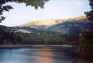
Tsivlos is a small mountain village in the municipality of Akrata, Achaea, Greece. It is part of the community Platanos. In 2011, it had a population of 9. It is built on the slopes of Mount Chelmos (Aroania), above the river Krathis, at about 750 m elevation. Lake Tsivlos, north of the village, was formed by a landslide in 1912. Tsivlos is located 12 km southwest of Akrata, 12 km northeast of Kalavryta and 11 km south of Platanos.
Agrampela is a village and a community in the municipal unit of Aroania, Achaea, Greece. The community includes the village Platanitsa. It is situated in the southern foothills of the Mount Erymanthos. It is 2 km northwest of Plaka, 8 km east of Kalentzi and 26 km southwest of Kalavryta.
Lechouri is a mountain village and a community in the municipal unit of Aroania, Achaea, Greece. The community includes the villages Kerasia and Selli. The village is situated at about 900 m above sea level, near the mountain Kallifoni, which is part of the Erymanthos range. It is 4 km northeast of Livartzi, 6 km south of Ano Vlasia, 4 km northwest of Kamenianoi and 18 km southwest of Kalavryta.

Livartzi is a mountain village and a community in the municipal unit of Aroania, Achaea, Greece. The community includes the villages Livadi and Livartzino. Livartzi is situated at 850 m above sea level, in the southeastern foothills of Mount Erymanthos. It is 4 km southwest of Lechouri, 6 km north of Psofida and 21 km southwest of Kalavryta. It is not known when Livartzi was founded, but it existed before the Ottoman rule. In the 19th century, refugees from Mystras settled the area and the population rose to around 3,000 people.

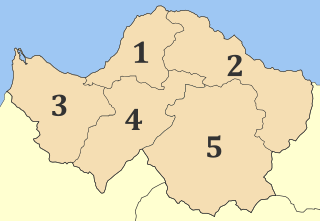
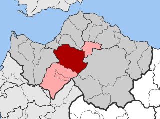
Erymanthos is a municipality in Achaea, Western Greece. The seat of the municipality is the town Chalandritsa. The municipality has an area of 582.139 km2. It was named after Mount Erymanthos.
Lakkomata is a mountain village and community in the municipality of Erymanthos in Achaea, Greece. According to the 2021 census, it had 61 inhabitants. In 2011 the village had 113 inhabitants and the community, which also includes the settlement Tsapournia, 133 inhabitants.

