Related Research Articles

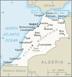
High Atlas, also called the Grand Atlas, is a mountain range in central Morocco, North Africa, the highest part of the Atlas Mountains.

The Central Atlantic magmatic province (CAMP) is the Earth's largest continental large igneous province, covering an area of roughly 11 million km2. It is composed mainly of basalt that formed before Pangaea broke up in the Mesozoic Era, near the end of the Triassic and the beginning of the Jurassic periods. The subsequent breakup of Pangaea created the Atlantic Ocean, but the massive igneous upwelling provided a legacy of basaltic dikes, sills, and lavas now spread over a vast area around the present central North Atlantic Ocean, including large deposits in northwest Africa, southwest Europe, as well as northeast South and southeast North America. The name and CAMP acronym were proposed by Andrea Marzoli and adopted at a symposium held at the 1999 Spring Meeting of the American Geophysical Union.
The Late Triassic is the third and final epoch of the Triassic Period in the geologic timescale. The Triassic-Jurassic extinction event began during this epoch and is one of the five major mass extinction events of the Earth. The corresponding series is known as the Upper Triassic. In Europe the epoch was called the Keuper, after a German lithostratigraphic group that has a roughly corresponding age. The Late Triassic spans the time between 237 Ma and 201.3 Ma. It is preceded by the Middle Triassic epoch and is followed by the Early Jurassic epoch. The Late Triassic is divided into the Carnian, Norian and Rhaetian ages.
The Newark Supergroup, also known as the Newark Group, is an assemblage of Upper Triassic and Lower Jurassic sedimentary rocks which outcrop intermittently along the United States East Coast. They were deposited in a series of Triassic basins approximately 190 million years ago as North America separated from Africa. The exposures extend from Nova Scotia to North Carolina. Related basins are also found underwater in the Bay of Fundy. The group is named for the city of Newark, New Jersey.

Cimmeria was an ancient continent, or, rather, a string of microcontinents or terranes, that rifted from Gondwana in the Southern Hemisphere and was accreted to Eurasia in the Northern Hemisphere. It consisted of parts of what is today Turkey, Iran, Afghanistan, Tibet, Shan–Thai, and Malay Peninsula. Cimmeria rifted from the Gondwanan shores of the Paleo-Tethys Ocean during the Carboniferous-earliest Permian and as the Neo-Tethys Ocean opened behind it, during the Permian, the Paleo-Tethys closed in front of it. Cimmeria rifted off Gondwana from east to west, from Australia to the eastern Mediterranean. It stretched across several latitudes and spanned a wide range of climatic zones.

The geology of Norway encompasses the history of earth that can be interpreted by rock types found in Norway, and the associated sedimentological history of soils and rock types.
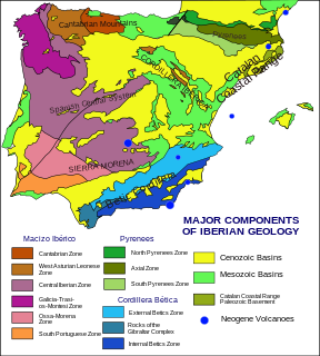
The geology of the Iberian Peninsula consists of the study of the rock formations on the Iberian Peninsula, which includes Spain, Portugal, Andorra, and Gibraltar. The peninsula contains rocks from every geological period from the Ediacaran to the Quaternary, and many types of rock are represented. World-class mineral deposits are also found there.
The Cheshire Basin is a late Palaeozoic and Mesozoic sedimentary basin extending under most of the county of Cheshire in northwest England. It extends northwards into the Manchester area and south into Shropshire. The basin possesses something of the character of a half-graben as its deepest extent is along its eastern and southeastern margins, where it is well defined by a series of sub-parallel faults, most important of which is the Red Rock Fault. These faults divide the basin from the older Carboniferous rocks of the Peak District and the North Staffordshire Coalfield.

The Blue Nile Basin is a major geological formation in the northwestern Ethiopian Plateau formed in the Mesozoic Era during a period of crustal extension associated with the break-up of Gondwana, and filled with sedimentary deposits. The modern Blue Nile river cuts across part of the sedimentary basin.

Paleontology in Rhode Island refers to paleontological research occurring within or conducted by people from the U.S. state of Rhode Island. Rhode Island has a relatively sparse fossil record. Among its more common fossils are plant remains that are frequently associated with the state's coal beds. During the early Paleozoic, Rhode Island was at least partially submerged under a sea inhabited by trilobites. During the Carboniferous period the state became a swampy environment where lush vegetation included trees more than 50 feet high. Local animal life included arachnids and insects like cockroaches. Rift basins formed locally during the Permian. The ensuing Triassic and Jurassic periods are absent from the state's rock record. Little is known about the state's Cretaceous history. The Paleogene and Neogene periods are also missing from Rhode Island's rock record. During the Pleistocene the state was subjected to glacial activity. Notable local fossil finds have included previously unknown kinds of insect and abundant ancient amphibian trackways.

The North Sea is part of the Atlantic Ocean in northern Europe. It is located between Norway and Denmark in the east, Scotland and England in the west, Germany, the Netherlands, Belgium and France in the south.

The formation of the Gulf of Mexico, an oceanic rift basin located between North America and the Yucatan Block, was preceded by the breakup of the Supercontinent Pangaea in the Late-Triassic, weakening the lithosphere. Rifting between the North and South American plates continued in the Early-Jurassic, approximately 160 million years ago, and formation of the Gulf of Mexico, including subsidence due to crustal thinning, was complete by 140 Ma. Stratigraphy of the basin, which can be split into several regions, includes sediments deposited from the Jurassic through the Holocene, currently totaling a thickness between 15 and 20 kilometers.

The North German Basin is a passive-active rift basin located in central and west Europe, lying within the southeasternmost portions of the North Sea and the southwestern Baltic Sea and across terrestrial portions of northern Germany, Netherlands, and Poland. The North German Basin is a sub-basin of the Southern Permian Basin, that accounts for a composite of intra-continental basins composed of Permian to Cenozoic sediments, which have accumulated to thicknesses around 10–12 kilometres (6–7.5 mi). The complex evolution of the basin takes place from the Permian to the Cenozoic, and is largely influenced by multiple stages of rifting, subsidence, and salt tectonic events. The North German Basin also accounts for a significant amount of Western Europe's natural gas resources, including one of the world's largest natural gas reservoir, the Groningen gas field.
The Tarfaya Basin is a structural basin located in southern Morocco that extends westward into the Moroccan territorial waters in the Atlantic Ocean. The basin is named for the city of Tarfaya located near the border of Western Sahara, a region governed by the Kingdom of Morocco. The Canary Islands form the western edge of the basin and lie approximately 100 km to the west.
The Faroe-Shetland Basin is a sedimentary basin formed by mainly Mesozoic rifting that lies between the Faroe Islands and the Shetland Islands. It has been the site of hydrocarbon exploration since the 1960s, with many significant oil and gas discoveries, including the Clair oilfield, which had an estimated 8 billion barrels of oil in place before production started, the Schiehallion oilfield and the Lancaster oilfield.

The Lusitanian Basin is a rift basin located on both the mainland and continental shelf off the west-central coast of Portugal. It covers an area measuring 20,000 square kilometres (7,700 sq mi) and extends north-south from Porto to Lisbon. The basin varies between approximately 130 kilometres (81 mi) and 340 kilometres (210 mi) in width and belongs to a family of periatlantic basins such as the Jeanne d'Arc Basin. To the east of the Lusitanian Basin lies the Central Plateau of the Iberian Peninsula. A marginal horst system lies to the west. The Alentejo and Algarve Basins connect to the southern end of the Lusitanian Basin. In the north, it connects to the Porto and Galicia Basins via an undersea ridge.

The geology of Lebanon remains poorly studied prior to the Jurassic. The country is heavily dominated by limestone, sandstone, other sedimentary rocks, and basalt, defined by its tectonic history. In Lebanon, 70% of exposed rocks are limestone karst.

Hebron Oil Field, located off the coast of Newfoundland, is the fourth field to come on to production in the Jeanne d'Arc Basin. Discovered in 1981 and put online in 2017, the Hebron field is estimated to contain over 700 million barrels of producible hydrocarbons. The field is contained within a fault-bounded Mesozoic rift basin called the Jeanne d'Arc Basin.
The geology of Bulgaria consists of two major structural features. The Rhodope Massif in southern Bulgaria is made up of Archean, Proterozoic and Cambrian rocks and is a sub-province of the Thracian-Anatolian polymetallic province. It has dropped down, faulted basins filled with Cenozoic sediments and volcanic rocks. The Moesian Platform to the north extends into Romania and has Paleozoic rocks covered by rocks from the Mesozoic, typically buried by thick Danube River valley Quaternary sediments. In places, the Moesian Platform has small oil and gas fields. Bulgaria is a country in southeastern Europe. It is bordered by Romania to the north, Serbia and North Macedonia to the west, Greece and Turkey to the south, and the Black Sea to the east.
The geology of Romania is structurally complex, with evidence of past crustal movements and the incorporation of different blocks or platforms to the edge of Europe, driving recent mountain building of the Carpathian Mountains. Romania is a country located at the crossroads of Central, Eastern, and Southeastern Europe. It borders the Black Sea to the southeast, Bulgaria to the south, Ukraine to the north, Hungary to the west, Serbia to the southwest, and Moldova to the east.
References
- ↑ Ramos, A.; Fernández, O.; Terrinha, P.; Muñoz, J.A. "Extension and inversion structures in the Tethys–Atlantic linkage zone, Algarve Basin, Portugal" (PDF). International Journal of Earth Sciences. 105: 1663–1679. doi:10.1007/s00531-015-1280-1.