Alvington, Gloucestershire

Last updated

Alvington
A48, Alvington - geograph.org.uk - 2028571.jpg
A48 road through Alvington
Gloucestershire UK location map.svg
Red pog.svg
Alvington
Location within Gloucestershire
OS grid reference SO603008
Civil parish
  • Alvington
District
Shire county
Region
Country England
Sovereign state United Kingdom
Post town Lydney
Postcode district GL15
Police Gloucestershire
Fire Gloucestershire
Ambulance South Western
UK Parliament
List of places
UK
England
Gloucestershire
51°42′19″N2°34′32″W / 51.70515°N 2.57562°W / 51.70515; -2.57562 Coordinates: 51°42′19″N2°34′32″W / 51.70515°N 2.57562°W / 51.70515; -2.57562

Alvington is a village and civil parish in the Forest of Dean in Gloucestershire, England, situated on the A48 road, six miles north-east of Chepstow in Wales. The parish had a total population of 506 at the 2011 census. [1]

Contents

History of Alvington

Alvington was one of a number of hamlets dotted along the River Severn, following the former Roman road leading from Newnham on Severn to Chepstow. The manor of Alvington is recorded in the Domesday Book of 1086 under the name ‘Alwintune’, then part of the Herefordshire hundred of Bromsash, [2] held by Turstin FitzRolf. [3] During the 12th century, Alvington joined Gloucestershire as part of the Bledisloe hundred, and became a separate parish. During the late Middle Ages Alvington parish and manor were under the ownership of Llanthony Priory (in Gloucester) which was dissolved in 1539. The lord of the manor's seat was situated in Clanna Falls around one mile from the village. In its history Alvington, has variously boasted two smithies, a small brewery, a small engineering works and several shops. [4]

Society and amenities

Alvington's population had varied somewhere between 300 and 500 since the mid-19th century. During the 1960s the development of a council estate increased the size of the village. [4] The village lies at the edge of the Forest of Dean, which was once an important coal-producing area. There is a strong agricultural influence in the village today, although historically this would have been more evident and many of the population now work outside of the village and its immediate surroundings.

There used to be a village school in Alvington dating back to around 1850, however the last remnants of what became Alvington Church of England School closed in 1958. [4]

Today, Alvington has little in the way of shops and villagers have to travel to the nearby town of Lydney for most services beyond those served by the local petrol station, which acts as the village shop. There are three public houses in Alvington: The Blacksmith's Arms; The Globe Inn (which reopened in November 2014); and The Swan Inn (currently closed but having renovations). The Globe Inn dates back to around 1805. The Blacksmith's Arms dates back the late nineteenth-century in a building that was formerly a smithy (hence the pub's current name). The Swan Inn (now the Swan House Tea Rooms) lies on the border of Alvington and neighbouring Woolaston (also classed as Colne Valley), and once contained a mill in its early days. [4] [5] [6]

St. Andrew’s church

Built by Llanthony Priory around 1140, the church was originally named St. Mary's, until it took its current name of St. Andrew’s in 1523. In 1858 the church underwent substantial restoration leaving only one small Norman architecture window to reveal its Norman origins. [7] St. Andrew's, Alvington is in the Parish of Woolaston and Alvington, in the Deanery of Forest South under the Diocese of Gloucester. [8] St. Andrew's, Alvington is found on Church Lane and a village hall was built nearby in 1924.

Transport

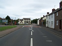
Alvington lies on the A48 road, which runs from Chepstow in Monmouthshire, Wales, to Gloucester, England. [9] The nearest railway stations can also be found in Lydney (on local trains from Gloucester) and Chepstow on more regular national routes. The Stagecoach West number 24 bus serves the village on its Chepstow to Cinderford route from Mondays to Saturdays. [10]

Politics

Alvington is represented by the county councillor for Tidenham division and the two district councillors for Alvington, Aylburton and West Lydney ward in the Forest of Dean District Council. The Forest of Dean is represented in Parliament by Mark Harper MP (Conservative Party). [11]

Sport

Alvington and Woolaston Cricket Club was founded in 1983, originally playing at Woolaston Primary School, they now play their home fixtures in Alvington. [12] The club competes in the K. W. Bell Forest League and the Forest Mid-Week League. Alvington football team reformed in 2016 after 40 years.

Paranormal activity

The village has been at the centre of a number of paranormal claims in recent years. In 2009 local resident David Crook claimed to have spotted bright lights in the sky above the playing fields. The lights burned brightly in the sky to such an extent that David rushed into the village, knocking on doors, to warn local residents. The lights turned out to be a child up a tree with a torch. But David to this day still claims it was aliens. [13]

Related Research Articles

Forest of Dean Geographical, historical and cultural region in Gloucestershire, England

The Forest of Dean is a geographical, historical and cultural region in the western part of the county of Gloucestershire, England. It forms a roughly triangular plateau bounded by the River Wye to the west and northwest, Herefordshire to the north, the River Severn to the south, and the City of Gloucester to the east.

Cinderford Human settlement in England

Cinderford is a town and civil parish on the eastern fringe of the Forest of Dean in Gloucestershire, England, which had a population of 8,494 at the 2011 census.

Forest of Dean District Non-metropolitan district in England

Forest of Dean is a local government district in Gloucestershire, England, named after the Forest of Dean. Its council is based in Coleford. Other towns and villages in the district include Blakeney, Cinderford, Drybrook, English Bicknor, Huntley, Littledean, Longhope, Lea, Lydbrook, Lydney, Mitcheldean, Newnham and Newent.

St Briavels Human settlement in England

St Briavels, is a medium-sized village and civil parish in the Royal Forest of Dean in west Gloucestershire, England; close to the England-Wales border, and 5 miles (8 km) south of Coleford. It stands almost 800 feet (240 m) above sea level on the edge of a limestone plateau above the valley of the River Wye, above an ancient meander of the river. To the west, Cinder Hill drops off sharply into the valley. It is sheltered behind the crumbling walls of the 12th century St Briavels Castle.

Awre Human settlement in England

Awre is a village, civil parish and electoral ward in the Forest of Dean district of Gloucestershire, England, near the River Severn.

Aylburton Human settlement in England

Aylburton is a village and civil parish in the Forest of Dean district of Gloucestershire, England, on the A48 road about two miles south-west of Lydney. According to the 2001 census it had a population of 689, increasing to 711 at the 2011 census.

Lydney was a rural district in Gloucestershire, England from 1894 to 1974. It covered an area on the Welsh border by the Severn estuary.

Mitcheldean Human settlement in England

Mitcheldean is a historic market town in the east of the Forest of Dean, Gloucestershire, England.

English Bicknor Human settlement in England

English Bicknor is a village and civil parish in the Forest of Dean district of west Gloucestershire, England. The 2011 Census recorded the population as 408. The village is near the county boundary with Herefordshire, opposite which is the village of Welsh Bicknor. The two villages are on opposite sides of the River Wye.

A466 road

The A466, also known as the Wye Valley Road, is a road from Hereford, England to Chepstow, Wales via Monmouth, Tintern and the Wye Valley.

Drybrook Human settlement in England

Drybrook is a village and civil parish in the Forest of Dean in west Gloucestershire, England..

Clearwell Human settlement in England

Clearwell is a village and former ancient manor in the Forest of Dean, West Gloucestershire, England. A recent survey indicated that the population of Clearwell is approximately 350.

Woolaston Human settlement in England

Woolaston is a village and civil parish in the Forest of Dean district of Gloucestershire in South West England. It lies on the north side of the Severn Estuary approximately 5 miles from the Welsh border at Chepstow and is surrounded by woodland and agricultural land.

Pidcocks Canal

Pidcock's Canal was a canal in Gloucestershire, England, which connected ironworks at Upper Forge and Lower Forge, and also ran to an inlet from the River Severn called Lydney Pill. It was constructed from 1778 onwards, and there were three locks below Middle Forge. Following the construction of the Lydney Canal in 1813, the canal connected to that, rather than Lydney Pill, and it was disused after 1840, by which time a horse-drawn tramway had been built up the valley of The Lyd. The tramway was eventually relaid as a steam railway and is now preserved as the Dean Forest Railway. Most of the canal, colloquially called The Cut, still exists below Middle Forge.

Brockweir Human settlement in England

Brockweir is a village in Hewelsfield and Brockweir civil parish, in the Forest of Dean District of Gloucestershire, England. The civil parish also includes the separate village of Hewelsfield.

Steam Mills Human settlement in England

Steam Mills is a village in the Forest of Dean, west Gloucestershire, England.

East Dean was a township, and later civil parish, in Gloucestershire, England. It was created as a township in 1844 and abolished as a civil parish in 1953. Its former area is now part of the Forest of Dean district.

Hewelsfield Human settlement in England

Hewelsfield is a village in Hewelsfield and Brockweir civil parish, in the Forest of Dean district of Gloucestershire, England.

Bledisloe Hundred

Bledisloe was an ancient hundred of Gloucestershire, England. It comprised the ancient parishes of

Hewelsfield and Brockweir Human settlement in England

Hewelsfield and Brockweir is a civil parish in Forest of Dean District, Gloucestershire. The parish was called Hewelsfield until 1994. It contains two distinct villages, Hewelsfield and Brockweir, with scattered settlement on Hewelsfield common.

References

  1. "Parish population 2011". Archived from the original on 2 April 2015. Retrieved 26 March 2015.
  2. VCH, Alvington', A History of the County of Gloucester: Volume 5: Bledisloe Hundred, St. Briavels Hundred, The Forest of Dean (1996), pp. 5-14.
  3. "Archived copy". Archived from the original on 31 July 2020. Retrieved 25 August 2020.CS1 maint: archived copy as title (link)
  4. 1 2 3 4 "Alvington Pages 5-14 A History of the County of Gloucester: Volume 5, Bledisloe Hundred, St. Briavels Hundred, the Forest of Dean". British History Online. Victoria County History. Archived from the original on 25 July 2019. Retrieved 25 August 2020.
  5. "Swan House Tea Room". Swan House Tea Room. Archived from the original on 2 December 2018. Retrieved 25 August 2020.
  6. "Swan". What Pub. Archived from the original on 25 August 2020. Retrieved 25 August 2020.
  7. "Church of St Andrew". National Heritage List for England. Historic England. Archived from the original on 25 August 2020. Retrieved 25 August 2020.
  8. "St Andrew". A Church Near You. Church of England. Archived from the original on 25 August 2020. Retrieved 25 August 2020.
  9. "Alvington". Forest of Dean and Wye Valley. Archived from the original on 25 August 2020. Retrieved 25 August 2020.
  10. "24 Bus Route & Timetable: Cinderford - Chepstow". Stagecoach. Archived from the original on 25 August 2020. Retrieved 25 August 2020.
  11. "Mark Harper's Conservative Party Website profile". Archived from the original on 8 May 2013. Retrieved 9 June 2009.
  12. "Alvington & Woolaston CC". Play Cricket. Archived from the original on 27 July 2019. Retrieved 25 August 2020.
  13. "Seven seduced by bright lights of Alvington". Forest of Dean and Wye Valley Review. 26 August 2009. Archived from the original on 25 August 2020. Retrieved 25 August 2020.