Ambenja

Last updated
Ambenja
Madagascar location map.svg
Red pog.svg
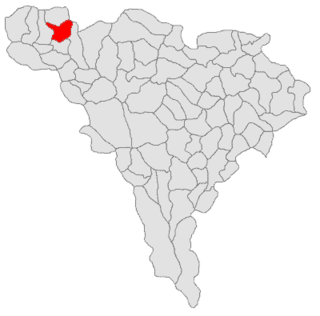
Ambenja
Location in Madagascar
Coordinates: 15°17′0″S46°58′0″E / 15.28333°S 46.96667°E / -15.28333; 46.96667
CountryFlag of Madagascar.svg  Madagascar
Region Boeny

Ambenja ( /ˈɑːmbɛbnə/ ) is a coastal town in the Boeny Region of northwestern Madagascar. It is located near the Mozambique Channel and is approximately 70 kilometers north of Mahajanga.

Boeny Region in Madagascar

Boeny is a region in northwestern Madagascar. It borders Sofia Region to the northeast, Betsiboka to the south and Melaky to the southwest. The capital of the region is Mahajanga, and the population was estimated to be 799,675 in 2013. The area of Boeny is 31,046 km2 (11,987 sq mi).

Madagascar island nation off the coast of Southeast Africa, in the Indian Ocean

Madagascar, officially the Republic of Madagascar, and previously known as the Malagasy Republic, is an island country in the Indian Ocean, approximately 400 kilometres off the coast of East Africa. The nation comprises the island of Madagascar and numerous smaller peripheral islands. Following the prehistoric breakup of the supercontinent Gondwana, Madagascar split from the Indian subcontinent around 88 million years ago, allowing native plants and animals to evolve in relative isolation. Consequently, Madagascar is a biodiversity hotspot; over 90% of its wildlife is found nowhere else on Earth. The island's diverse ecosystems and unique wildlife are threatened by the encroachment of the rapidly growing human population and other environmental threats.

Mozambique Channel Indian Ocean strait between Madagascar and Mozambique

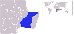
The Mozambique Channel is an arm of the Indian Ocean located between the Southeast African countries of Madagascar and Mozambique. The channel is about 1,600 km (1,000 mi) long and 419 km (260 mi) across at its narrowest point, and reaches a depth of 3,292 m (10,800 ft) about 230 km (143 mi) off the coast of Mozambique. A warm current, the Mozambique Current, flows in a southward direction in the channel, leading into the Agulhas Current off the east coast of South Africa.

Coordinates: 15°17′S46°58′E / 15.283°S 46.967°E / -15.283; 46.967

Geographic coordinate system Coordinate system

A geographic coordinate system is a coordinate system that enables every location on Earth to be specified by a set of numbers, letters or symbols. The coordinates are often chosen such that one of the numbers represents a vertical position and two or three of the numbers represent a horizontal position; alternatively, a geographic position may be expressed in a combined three-dimensional Cartesian vector. A common choice of coordinates is latitude, longitude and elevation. To specify a location on a plane requires a map projection.

Related Research Articles

Arctic Archipelago Canadian archipelago

The Arctic Archipelago, also known as the Canadian Arctic Archipelago, is a group of islands north of the Canadian mainland.

Pole of inaccessibility most distant point from any coastline

A pole of inaccessibility with respect to a geographical criterion of inaccessibility marks a location that is the most challenging to reach according to that criterion. Often it refers to the most distant point from the coastline, implying a maximum degree of continentality or oceanity. In these cases, pole of inaccessibility can be defined as the center of the largest circle that can be drawn within an area of interest without encountering a coast. Where a coast is imprecisely defined, the pole will be similarly imprecise.

Jocón Municipality in Yoro, Honduras

Jocón is a municipality in the department of Yoro, Honduras.

Albac Commune in Alba County, Romania

Albac is a commune located in Alba County, Romania. It has a population of 2,220, and is composed of sixteen villages: Albac, Bărăști, Budăiești, Cionești, Costești, Dealu Lămășoi, Deve, După Pleșe, Fața, Pleșești, Potionci, Rogoz, Roșești, Rusești, Sohodol and Tamborești.

Saschiz Commune in Mureș County, Romania

Saschiz is a commune in Mureș County, Romania. It has a population of 2,048: 88% Romanians, 5% Germans, 4% Hungarians and 3% Roma. It is composed of three villages: Cloașterf, Mihai Viteazu and Saschiz.

Mooki River river in New South Wales, Australia

Mooki River, a perennial stream that is part of the Namoi catchment within the Murray–Darling basin, is located in the Northern Tablelands district of New South Wales, Australia.

Mangidrano Place in Sofia, Madagascar

Mangidrano or Mangindrano is a town and commune in Madagascar. It belongs to the district of Bealanana, which is a part of Sofia Region. The population of the commune was estimated to be approximately 13,000 in the 2001 commune census.

Antanambao Andranolava Place in Boeny, Madagascar

Antanambao Andranolava is a town and commune in Madagascar. It belongs to the district of Marovoay, which is a part of Boeny Region. The population of the commune was estimated to be approximately 5,000 in 2001 commune census.

Horea, Alba Commune in Alba County, Romania

Horea is a commune located in Alba County, Romania. It has a population of 2,371, and is composed of fifteen villages: Baba, Butești, Dârlești, Fericet, Giurgiuț, Horea, Măncești, Mătișești, Niculești, Pătrușești, Petreasa, Preluca, Teiu, Trifești and Zânzești.

Belazao Place in Vakinankaratra, Madagascar

Belazao is a town and commune in Madagascar. It belongs to the district of Antsirabe II, which is a part of Vakinankaratra Region. The population of the commune was estimated to be approximately 11,000 in 2001 commune census. Belazao is located near the lake Tritriva.

Vohimary Place in Atsimo-Atsinanana, Madagascar

Vohimary is a town and commune in Madagascar. It belongs to the district of Vondrozo, which is a part of Atsimo-Atsinanana Region. The population of the commune was estimated to be approximately 5,000 in 2001 commune census.

Samociążek Village in Kuyavian-Pomeranian, Poland

Samociążek is a village in the administrative district of Gmina Koronowo, within Bydgoszcz County, Kuyavian-Pomeranian Voivodeship, in north-central Poland. It lies 5 kilometres (3 mi) south-east of Koronowo and 19 km (12 mi) north of Bydgoszcz.

Pokoje Village in Greater Poland, Poland

Pokoje is a village in the administrative district of Gmina Słupca, within Słupca County, Greater Poland Voivodeship, in west-central Poland. It lies approximately 8 kilometres (5 mi) east of Słupca and 73 km (45 mi) east of the regional capital Poznań.

Hořešovičky Municipality and village in Central Bohemian Region, Czech Republic

Hořešovičky is a village and municipality in Kladno District in the Central Bohemian Region of the Czech Republic.

German submarine U-967 was a Type VIIC/41 U-boat of Nazi Germany's Kriegsmarine. Her keel was laid down on 16 May 1942 by Blohm & Voss of Hamburg, Germany. She was commissioned on 11 March 1943 with Oberleutnant zur See Herbert Loeder in command. U-967 commanded by Albrecht Brandi on 5 May 1944 torpedoed USS Fechteler in the Western Mediterranean that was sailing with convoy GUS-38.

Gősfa is a village in Zala County, Hungary.

Zalabér is a village in Zala County, Hungary.

Kumarevo is a village in the municipality of Vranje, Serbia. According to the 2002 census, the village has a population of 283 people.

Ellis Glacier glacier in Antarctica

Ellis Glacier is a glacier, 4 nautical miles (7 km) long, flowing north from Mount Walnum between Gillock Glacier and Jennings Glacier in the Sør Rondane Mountains of Antarctica. It was mapped by Norwegian cartographers in 1957 from air photos taken by U.S. Navy Operation Highjump, 1946–47, and named for Edwin E. Ellis, aerial photographer on Operation Highjump photographic flights in this area and other coastal areas between 14°E and 164°E.

References