Katsepy

Last updated
Katsepy
Le phare de Katsepy.JPG
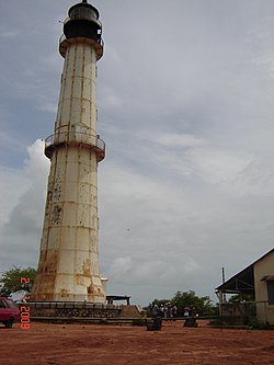
Light House of Katsepy
Madagascar location map.svg
Red pog.svg
Katsepy
Location in Madagascar
Coordinates: 15°46′S46°14′E / 15.767°S 46.233°E / -15.767; 46.233
CountryFlag of Madagascar.svg  Madagascar
Region Boeny
District Mitsinjo
Elevation
[1]
25 m (82 ft)
Population
 (2001) [2]
  Total10,000
Time zone UTC3 (EAT)
Postal code
417

Katsepy is a municipality in Madagascar. It belongs to the district of Mitsinjo, which is a part of Boeny Region. The population of the commune was estimated to be approximately 10,000 in 2001 commune census. [2]

the Port of Katsepy Le port de Katsepy.JPG
the Port of Katsepy

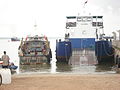
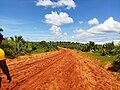
Katsepy has a maritime harbour. It is situated on the opposite side of the Betsiboka River from Mahajanga from where the town can be reached by a ferry. Only primary schooling is available. Farming and raising livestock provides employment for 40% and 30% of the working population. The most important crop is rice, while other important products are seeds of catechu and raffia palm. Services provide employment for 1% of the population. Additionally fishing employs 29% of the population. [2]

Before 2006, a project for building an ethanol plant was started. During two years, all studies are realized. However, the unsettled political climate in Madagascar put an end to this project. [3]

Infrastructures

Katsepy has a small riverine harbour for the ferry across the Bombetoka Bay to Mahajanga. It is also the startpoint of the unpaved National road 19 to Soalala and Maintirano.

Light House

In Katsepy is found a light house that was constructed in 1901. [4]

  1. Estimated based on DEM data from Shuttle Radar Topography Mission
  2. 1 2 3 "ILO census data". Cornell University. 2002. Retrieved 2008-03-03.
  3. Madagascar Ethanol programm
  4. Sea Seek: Phare de Katsepy

15°46′S46°14′E / 15.767°S 46.233°E / -15.767; 46.233

Related Research Articles

Marosakoa is a municipality in western Madagascar over the Mozambique Channel. It is approximately 35 kilometres south of Mahajanga. It belongs to the district of Marovoay, which is a part of Boeny Region. The population of the commune was estimated to be approximately 10,000 in 2001 commune census.

<span class="mw-page-title-main">Maevatanana</span> Place in Betsiboka, Madagascar

Maevatanana is an urban municipality in Madagascar. The city is in the central-north part of the island, at the Ikopa River, and is connected by the national road RN 4 to Antananarivo and Mahajanga. The altitude is low and as it is located far from the coast, temperatures tend to be high. The city belongs to the district of Maevatanana, which is a part of Betsiboka Region. Maevatanana is the capital of the Betsiboka region, and the population of the commune was estimated to be approximately 24,000 in 2001 commune census.

Marovoay is an urban municipality in north-western Madagascar. It belongs to the district of Marovoay, which is a part of Boeny Region. The population of the commune was estimated to be approximately 65,000 in 2001 commune census.

<span class="mw-page-title-main">Boeny</span> Region in Madagascar

Boeny is a region in northwestern Madagascar. It borders Sofia Region to the northeast, Betsiboka to the south and Melaky to the southwest. The capital of the region is Mahajanga, and the population was 931,171 in 2018. The area of Boeny is 31,046 km2 (11,987 sq mi).

Ambolomoty is a rural municipality in Madagascar. It belongs to the district of Marovoay, which is a part of Boeny Region. It is situated at a distance of 99 km from Mahajanga at the National road 8. The population of the commune was estimated to be approximately 12,000 in 2001 commune census.

Ankazomborona is a rural municipality in Madagascar. It belongs to the district of Marovoay, which is a part of Boeny Region. The population of the commune was estimated to be approximately 25,000 in 2001 commune census.

Antanimasaka is a town and commune in Madagascar. It belongs to the district of Marovoay, which is a part of Boeny Region. The population of the commune was estimated to be approximately 8,000 in 2001 commune census.

Marovoay Banlieue is a rural municipality in Madagascar. It belongs to the district of Marovoay, which is a part of Boeny Region. The population of the commune was estimated to be approximately 9,000 in 2001 commune census.

<span class="mw-page-title-main">Andranofasika</span> Place in Boeny, Madagascar

Andranofasika is a rural commune in Madagascar. It belongs to the district of Ambato-Boeni, which is a part of Boeny Region. The population of the commune was estimated to be 16,971 in 2018.

Andranoboka is a town and commune in Madagascar. It belongs to the district of Mahajanga II, which is a part of Boeny Region. The population of the commune was estimated to be approximately 4,000 in the 2001 commune census.

Bekobay is a town and commune in Madagascar. It belongs to the district of Mahajanga II, which is a part of Boeny Region. The population of the commune was estimated to be approximately 5,000 in 2001 commune census.

Belobaka is a rural municipality in Madagascar. It belongs to the district of Mahajanga II, which is a part of Boeny Region. The population of the municipality was estimated to be approximately 12,000 in 2001 commune census.

<span class="mw-page-title-main">Betsako</span> Place in Boeny, Madagascar

Betsako is a town and commune in Madagascar. It belongs to the district of Mahajanga II, which is a part of Boeny. The population of the commune was estimated to be approximately 7,000 in a 2001 commune census.

Boanamary is a rural municipality in Madagascar. It belongs to the district of Mahajanga II, which is a part of Boeny Region. The population of the commune was estimated to be approximately 10,000 in 2001 commune census.

Mariarano is a rural municipality in Madagascar. It belongs to the district of Mahajanga II, which is a part of Boeny Region. The population of the commune was estimated to be approximately 6,000 in the 2001 commune census.

Antanimbary is a town and commune in Madagascar. It belongs to the district of Maevatanana, which is a part of Betsiboka Region. The population of the commune was estimated to be approximately 3,000 in 2001 commune census.

Mananara Nord or Mananara Avaratra is a municipality in Madagascar. It belongs to the district of Mananara Nord, which is a part of Analanjirofo Region. The population of the commune was 35,148 in 2018.

<span class="mw-page-title-main">Saint Augustin, Madagascar</span> Place in Toliara, Madagascar

Saint Augustin is a rural municipality in Madagascar. It belongs to the district of Toliara II, which is a part of Atsimo-Andrefana Region. The population of the commune was estimated to be approximately 15,000 in 2001 commune census. The mouth of the Onilahy River is near the town.

Ankililoake is a rural municipality in Madagascar. It belongs to the district of Toliara II, which is a part of Atsimo-Andrefana Region. The population of the commune was estimated to be approximately 21,000 in 2001 commune census.

Antanimeva is a town and commune in Madagascar. It belongs to the district of Morombe, which is a part of Atsimo-Andrefana Region. The population of the commune was estimated to be approximately 24,000 in 2001 commune census.