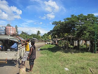
Ankijabe is a town and commune (Malagasy: kaominina) in Madagascar. It belongs to the district of Ambato-Boeni, which is a part of Boeny Region. The population of the commune was estimated to be approximately 19,000 in 2001 commune census.[2]
Malagasy is an Austronesian language and the national language of Madagascar. Most people in Madagascar speak it as a first language as do some people of Malagasy descent elsewhere.
Madagascar, officially the Republic of Madagascar, and previously known as the Malagasy Republic, is an island country in the Indian Ocean, approximately 400 kilometres off the coast of East Africa. The nation comprises the island of Madagascar and numerous smaller peripheral islands. Following the prehistoric breakup of the supercontinent Gondwana, Madagascar split from the Indian subcontinent around 88 million years ago, allowing native plants and animals to evolve in relative isolation. Consequently, Madagascar is a biodiversity hotspot; over 90% of its wildlife is found nowhere else on Earth. The island's diverse ecosystems and unique wildlife are threatened by the encroachment of the rapidly growing human population and other environmental threats.
Districts are second-level administrative divisions of Madagascar below the regions. There are 114 districts in Madagascar. Districts are in their turn divided into communes; while some of the districts in urban areas and offshore islands each consist of only one commune, most of the districts are divided typically into 5–20 communes.
Only primary schooling is available. The majority 55% of the population of the commune are farmers, while an additional 32% receives their livelihood from raising livestock. The most important crop is rice, while other important products are peanuts, maize and sweet potatoes. Services provide employment for 3% of the population. Additionally fishing employs 10% of the population.[2]
Rice is the seed of the grass species Oryza sativa or Oryza glaberrima. As a cereal grain, it is the most widely consumed staple food for a large part of the world's human population, especially in Asia. It is the agricultural commodity with the third-highest worldwide production, after sugarcane and maize.
The peanut, also known as the groundnut, goober, or monkey nut (UK), and taxonomically classified as Arachis hypogaea, is a legume crop grown mainly for its edible seeds. It is widely grown in the tropics and subtropics, being important to both small and large commercial producers. It is classified as both a grain legume and, due to its high oil content, an oil crop. World annual production of shelled peanuts was 44 million tonnes in 2016, led by China with 38% of the world total. Atypically among crop plants, peanut pods develop underground (geocarpy) rather than aboveground. With this characteristic in mind, the botanist Linnaeus named the species hypogaea, which means "under the earth."
Maize, also known as corn, is a cereal grain first domesticated by indigenous peoples in southern Mexico about 10,000 years ago. The leafy stalk of the plant produces pollen inflorescences and separate ovuliferous inflorescences called ears that yield kernels or seeds, which are fruits.
A geographic coordinate system is a coordinate system that enables every location on Earth to be specified by a set of numbers, letters or symbols. The coordinates are often chosen such that one of the numbers represents a vertical position and two or three of the numbers represent a horizontal position; alternatively, a geographic position may be expressed in a combined three-dimensional Cartesian vector. A common choice of coordinates is latitude, longitude and elevation. To specify a location on a plane requires a map projection.
This page is based on this Wikipedia article Text is available under the CC BY-SA 4.0 license; additional terms may apply. Images, videos and audio are available under their respective licenses.
Related Research Articles
Antsalova is a town and commune in western Madagascar. It belongs to the district of Antsalova, which is a part of Melaky Region. The population of the commune was estimated to be approximately 16,000 in 2001 commune census.
Mahavanona is a town and commune in Madagascar. It belongs to the district of Antsiranana II, which is a part of Diana Region. It is located at the Besokatra River on the Route nationale 6 between Antsiranana and Anivorano Nord.
Ankatafa is a municipality in Madagascar. It belongs to the district of Ambanja, which is a part of Diana Region. According to 2001 census the population of Ankatafa was 8,652.
Antsahavaribe is a town and commune in northern Madagascar. It belongs to the district of Sambava, which is a part of Sava Region. The population of the commune was estimated to be approximately 17,000 in 2001 commune census.
Tsaramandroso is a town and commune in Madagascar. It belongs to the district of Ambato-Boeni, which is a part of Boeny Region. The population of the commune was estimated to be approximately 5,000 in 2001 commune census.
Tanananifololahy or Tanonanifololahy is a town and commune in Madagascar. It belongs to the district of Andilamena, which is a part of Alaotra-Mangoro Region. The population of the commune was estimated to be approximately 5,000 in 2001 commune census.
Ankililoake is a town and commune in Madagascar. It belongs to the district of Toliara II, which is a part of Atsimo-Andrefana Region. The population of the commune was estimated to be approximately 21,000 in 2001 commune census.
Ambinany is a town and commune in Madagascar. It belongs to the district of Sakaraha, which is a part of Atsimo-Andrefana Region. The population of the commune was estimated to be approximately 5,000 in 2001 commune census.
Inanantona or Inanantonana is a town and commune in Madagascar. It belongs to the district of Betafo, which is a part of Vakinankaratra Region. The population of the commune was estimated to be approximately 16,000 in 2001 commune census.
Ambohimanambola is a town and commune in Madagascar. It belongs to the district of Betafo, which is a part of Vakinankaratra Region. The population of the commune was estimated to be approximately 21,000 in 2001 commune census.
Amberomanga is a town and commune in Madagascar. It belongs to the district of Soavinandriana, which is a part of Itasy Region. The population of the commune was estimated to be approximately 5,000 in 2001 commune census.
Ambia is a town and commune in Madagascar. It belongs to the district of Ihosy, which is a part of Ihorombe Region. The population of the commune was estimated to be approximately 5,000 in 2001 commune census.
Marerano is a town and commune in Madagascar. It belongs to the district of Beroroha, which is a part of Atsimo-Andrefana Region. The population of the commune was estimated to be approximately 4,000 in 2001 commune census.
Ianapera is a town and commune in Madagascar. It belongs to the district of Benenitra, which is a part of Atsimo-Andrefana Region. The population of the commune was estimated to be approximately 10,000 in 2001 commune census.
Fenoarivo is a town and commune in Madagascar. It belongs to the district of Ambalavao, which is a part of Haute Matsiatra Region. The population of the commune was estimated to be approximately 8,000 in 2001 commune census.
Mahazoarivo is a town and commune in Madagascar. It belongs to the district of Fianarantsoa II, which is a part of Haute Matsiatra Region. The population of the commune was estimated to be approximately 12,000 in 2001 commune census.
Mahasolo is a town and commune in Madagascar. It belongs to the district of Tsiroanomandidy, which is a part of Bongolava Region. The population of the commune was estimated to be approximately 30,000 in 2001 commune census.
Marolinta is a town and commune in Madagascar. It belongs to the district of Beloha, which is a part of Androy Region.
Beapombo II is a town and commune in Madagascar. It belongs to the district of Betroka, which is a part of Anosy Region. The population of the commune was estimated to be approximately 5,000 in 2001 commune census.
Beretra Bevoay is a town and commune in Madagascar. It belongs to the district of Farafangana, which is a part of Atsimo-Atsinanana Region. The population of the commune was estimated to be approximately 10,000 in 2001 commune census.