Ampney Crucis

Last updated

Ampney Crucis
Church in Ampney Crucis - geograph.org.uk - 22372.jpg
Gloucestershire UK location map.svg
Red pog.svg
Ampney Crucis
Location within Gloucestershire
Population636 
OS grid reference SP0601
  London 80 mi (130 km)  E
District
Shire county
Region
Country England
Sovereign state United Kingdom
Post town Cirencester
Postcode district GL7
Dialling code 01285
Police Gloucestershire
Fire Gloucestershire
Ambulance South Western
UK Parliament
List of places
UK
England
Gloucestershire
51°42′58″N1°54′25″W / 51.716°N 1.907°W / 51.716; -1.907 Coordinates: 51°42′58″N1°54′25″W / 51.716°N 1.907°W / 51.716; -1.907

Ampney Crucis is a village and civil parish in the Cotswolds, part of the Cotswold District of Gloucestershire, England.

Contents

The village is in the Ampney-Coln electoral ward. This ward stretches from Ampney Crucis to Coln St. Dennis in the north. The total population of the ward at the 2011 census was 1,884. [1] [2]

The Ampney Brook, a tributary of the River Thames, flows through the village, which is near the smaller villages of Ampney St Mary and Ampney St Peter, and about 3 miles (5 km) east of Cirencester. [3]

History

At the time of the 1086 Domesday Book , the village was known as Omenie; in later centuries the name changed to Aminel, Aminie and eventually to Ampney. [4] In 1086, the lord of the village was Turstin FitzRolf. [5] A recent translation of the entry in the Book states: "In GARSDON Hundred Thurstan son of Rolf holds AMPNEY (Crucis) from the King". [6]

The village takes its current name (Latin for "Ampney of the Cross") from the brook and the 15th century cross in the churchyard of the parish church, the Church of the Holy Rood.

The Church of the Holy Rood is a Grade I listed building described as an "Anglican parish church. Saxon foundation, with some Norman work and elements from all periods including C15 tower and re-roofing of nave, up to restoration of 1870". [7] [8] The Ampney Crucis cross in the church courtyard is also Grade I listed, described as "Late C14/early C15" and restored in the late 20th century. The head was missing for years but was found in the tower in 1860 and reinstalled. [9]

In 1671 when households were assessed for the hearth tax, Ampney House was described as a "modest mansion in a park" and had ten hearths, while the Lloyds, the only other gentry family in the village, had seven hearths. Of the remaining dwellings with hearths, ten were exempt on the grounds of poverty while the remaining households each had a single hearth. At that time, apart from the lord of the manor and the Lloyds, the inhabitants of the parish were mostly their tenants; labourers, husbandmen and craftsmen, each with their own patch of ground to supply the family with food. [10]

In 1722, Sir John Playdell endowed a charity daily school. The population of the village's 2660 acres in 1801 was 541 and in 1831, it was 599. [11]

Many buildings in Ampney Crucis bear a Historic designation. [12]

The Grade II listed Ampney Park manor was built in the late 1500s and was extended in the 18th and 19th centuries. [13] Also Grade II listed, the small detached lodge was built in the mid 1600s and expanded in 1893. [14] The manor was built by John Pleydell; in 1724 it passed to the Yorkshire Dawnays. In 1765, it was sold to Samuel Blackwell; during his tenure the long Georgian north wing was added. A historical record states that the manor was the seat of Earl Dulcie in 1830, having rented the property after Blackwell's death. [15] The property was acquired in the 1890s by Edmund Cripps who extended the building. [16]

The 8-bedroom manor was listed for sale in 2018 as a 15,000 sq ft house with "magnificent equestrian facilities, a swimming pool, a 17th century Grand Hall", library and many other amenities, including a billiards room (added by Edmund Cripps). [17] [18]

Governance

Ampney Crucis has a Parish Council, currently with 5 members. The current Chair of the Council is local resident Douglas Crook.

As of May 2015 the village became part of 'The Ampneys and Hampton Ward' on Cotswold District Council. The current District Councillor is Liberal Democrat Lisa Spivey who was elected in the 2019 United Kingdom local elections.

Ampney Crucis is part of the wider South Cerney electoral division for elections to Gloucestershire County Council, Lisa Spivey who was elected in the 2021 United Kingdom local elections is also the County Councillor.

Related Research Articles

<span class="mw-page-title-main">Lechlade</span> Town in England

Lechlade is a town at the southern edge of the Cotswolds in Gloucestershire, England, 55 miles (89 km) south of Birmingham and 68 miles (109 km) west of London. It is the highest point at which the River Thames is navigable, although there is a right of navigation that continues south-west into Cricklade, in the neighbouring county of Wiltshire. The town is named after the River Leach that joins the Thames near the Trout Inn and St. John's Bridge.

<span class="mw-page-title-main">Fairford</span> Human settlement in England

Fairford is a small market town in Gloucestershire, England. The town lies in the Cotswold hills on the River Coln, 6 miles (9.7 km) east of Cirencester, 4 miles (6.4 km) west of Lechlade and 9 miles (14 km) north of Swindon. Nearby are RAF Fairford and the Cotswold Water Park.

<span class="mw-page-title-main">Down Ampney</span> Human settlement in England

Down Ampney is a medium-sized village located in Cotswold district in Gloucestershire, in England. The population taken at the 2011 census was 644.

<span class="mw-page-title-main">Bibury</span> Human settlement in England

Bibury is a village and civil parish in Gloucestershire, England. It is on the River Coln, a Thames tributary that rises in the same (Cotswold) District. The village centre is 6+12 miles northeast of Cirencester. Arlington Row is a nationally notable architectural conservation area depicted on the inside cover of all British passports. It is a major destination for tourists visiting the traditional rural villages, tea houses and many historic buildings of the Cotswold District; it is one of six places in the country featured in Mini-Europe, Brussels.

<span class="mw-page-title-main">Ablington, Gloucestershire</span> Human settlement in England

Ablington is a village in the county of Gloucestershire, England. It is located in the Coln Valley and is part of the Bibury civil parish, 6 miles (9.7 km) north-east of Cirencester. Ablington is in the Cotswolds which has been designated by Natural England as an Area of Outstanding Natural Beauty (AONB).

<span class="mw-page-title-main">Ampney St Mary</span> Human settlement in England

Ampney St Mary is a small village and civil parish in the Cotswolds, part of the Cotswold District of Gloucestershire, England. According to the 2001 census the parish has a population of 54, increasing to 218 at the 2011 census.

<span class="mw-page-title-main">Ampney St Peter</span> Human settlement in England

Ampney St Peter is a small village and civil parish in the Cotswolds, part of the Cotswold of Gloucestershire, England. According to the 2014 mid year estimate the parish has a population of 75. Locally the town was known as Easington.

<span class="mw-page-title-main">Ashley, Gloucestershire</span> Human settlement in England

Ashley is a village and civil parish in the Cotswold district of Gloucestershire, England, about 8 miles south-west of Cirencester. According to the 2001 census it had a population of 142, decreasing to 131 at the 2011 census. To the north, across the A433 road, is Trull House.

<span class="mw-page-title-main">Ashton Keynes</span> Village in Wiltshire, England

Ashton Keynes is a village and civil parish in north Wiltshire, England which borders with Gloucestershire. The village is about 5 miles (8 km) south of Cirencester and 3.5 miles (5.6 km) west of Cricklade. At the 2011 census the population of the parish, which includes the hamlet of North End, was 1,400.

<span class="mw-page-title-main">Barnsley, Gloucestershire</span> Human settlement in England

Barnsley is a village and civil parish in the Cotswold district of Gloucestershire, England, 3.7 miles (6.0 km) northeast of Cirencester. It is 125 kilometres (78 mi) (geodesically) west of London.

<span class="mw-page-title-main">Coln St. Aldwyns</span> Human settlement in England

Coln St. Aldwyns is a village and civil parish in the Cotswold district of the English county of Gloucestershire.

<span class="mw-page-title-main">Withington, Gloucestershire</span>

Withington is a Cotswold village and civil parish in Gloucestershire, England, about 6+12 miles (10 km) southeast of Cheltenham and 8 miles (13 km) north of Cirencester. The River Coln runs through the village. The parish includes the hamlets of Hilcot, Foxcote and Cassey Compton. The parish population taken at the 2011 census was 532.

<span class="mw-page-title-main">Siddington, Gloucestershire</span> Village and parish in Gloucestershire, England

Siddington is a village and civil parish in Gloucestershire, England. It is located immediately south of Cirencester. At the 2011 United Kingdom Census, the parish had a population of 1,249.

Meysey Hampton is a village and civil parish in Gloucestershire, England, approximately 30 miles (48 km) to the south-east of Gloucester. It lies in the south of the Cotswolds, an Area of Outstanding Natural Beauty.

<span class="mw-page-title-main">Miserden</span> Human settlement in England

Miserden is a village and civil parish in Stroud District, Gloucestershire, England, 4 miles north east of Stroud. The parish includes Whiteway Colony and the hamlets of Sudgrove and The Camp. In the 2001 census the parish had a population of 420, increasing to 449 at the 2011 census.

<span class="mw-page-title-main">Crudwell</span> Village in England

Crudwell is a village and civil parish in north Wiltshire, England. The nearest towns are Malmesbury, about 4 miles (6.4 km) to the south-west, and Cirencester, Gloucestershire 8 miles (13 km) to the north-east. Also to the north-east is Cotswold Airport. Kemble village, about 4 miles (6.4 km) away, has the nearest railway station, with services to London Paddington and Gloucester.

<span class="mw-page-title-main">Poulton, Gloucestershire</span> Human settlement in England

Poulton is a village and civil parish in the English county of Gloucestershire, approximately 24 miles (39 km) to the south-east of Gloucester. It lies in the south of the Cotswolds, an Area of Outstanding Natural Beauty. In the 2001 United Kingdom census, the parish had a population of 398, increasing to 408 at the 2011 census.

<span class="mw-page-title-main">North Cerney</span> Human settlement in England

North Cerney is a village and civil parish in the English county of Gloucestershire, and lies within the Cotswolds, a range of hills designated an Area of Outstanding Natural Beauty. The village is 4 miles (6.4 km) north of Cirencester within the Churn valley. It was recorded as Cernei in the Domesday Book. However, the North Cerney parish boundaries were known to exist in 852 AD when it was recorded that King of the Mercians granted lands in North Cerney to a man called Alfeah.

<span class="mw-page-title-main">Church of the Holy Rood, Ampney Crucis</span> Church

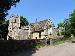
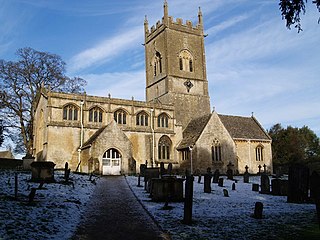
The Anglican Church of the Holy Rood at Ampney Crucis in the Cotswold District of Gloucestershire, England has Saxon foundations with some of the stonework being Norman. It is a grade I listed building. The listing summary describes it as an "Anglican parish church. Saxon foundation, with some Norman work and elements from all periods including C15 tower and re-roofing of nave, up to restoration of 1870".

<span class="mw-page-title-main">Ampney Park</span>

Ampney Park is a 16th century manor house at Ampney Crucis, Gloucestershire, England. It is a Grade II listed building.

References

  1. "Ampney-Coln ward 2011" . Retrieved 21 March 2015.
  2. "Parish population 2011" . Retrieved 21 March 2015.
  3. Concise Road Atlas of Britain. AA Publishing. 2016. p. 30. ISBN   978-0-7495-7743-8.
  4. Ampney Crucis
  5. "The Domesday Book online". Gloucestershire A-F. Retrieved 29 August 2016.
  6. Ampney Crucis Domesday Book
  7. Historic England. "CHURCH OF THE HOLY ROOD (1172051)". National Heritage List for England . Retrieved 17 June 2020.
  8. "Church of the Holy Rood, Ampney Crucis". British Listed Buildings. Retrieved 29 August 2016.
  9. Historic England. "CROSS IN CHURCHYARD OF CHURCH OF THE HOLY ROOD (1090016)". National Heritage List for England . Retrieved 17 June 2020.
  10. David Rollison (2011). Commune, Country and Commonwealth: The People of Cirencester, 1117-1643. Boydell & Brewer Ltd. pp. 221–222. ISBN   978-1-84383-671-1.
  11. The parliamentary gazetteer of England and Wales
  12. Ampney Crucis
  13. Historic England. "AMPNEY PARK (1090018)". National Heritage List for England . Retrieved 17 June 2020.
  14. Historic England. "THE LODGE, AMPNEY PARK (1305297)". National Heritage List for England . Retrieved 17 June 2020.
  15. Sporting Review: A Monthly Chronicle of the Turf, the Chase, and Rural Sports in All Their Varieties, Volume 1
  16. An idyllic country home with a breathtaking 17th century interior, plus pool, stables and an indoor arena
  17. Take a look inside the most expensive property for sale in Gloucestershire right now - an £8.5million Cotswold estate
  18. Ampney Crucis, Gloucestershire