Amtrak Susquehanna River Bridge

Last updated
Amtrak Susquehanna River Bridge
Southbound Acela Express crossing the Susquehanna River Bridge.jpg
Southbound Acela Express crosses the bridge in 2008. The piers of the predecessor P.W. & B. Railroad Bridge are to the right.
Coordinates 39°33′17″N76°05′06″W / 39.5548°N 76.0851°W / 39.5548; -76.0851
Carries Amtrak Northeast Corridor rail line
Crosses Susquehanna River
Locale Havre de Grace and Perryville, Maryland
Official nameSusquehanna River Movable Bridge
Maintained by Amtrak
Characteristics
DesignHowe deck truss
MaterialSteel
Total length4,153 feet (1,266 m) [1] :119
No. of spans18 (including center swing span) [1] :119
Clearance below 52 feet (15.8 m) when closed; 127 feet (38.7 m) when open [2]
Rail characteristics
No. of tracks 2
Track gauge Standard
History
Constructed by Pennsylvania Steel Company and American Bridge Company
OpenedMay 29, 1906 [3]
Statistics
Daily traffic Over 110 passenger and freight trains per day [4]
Location
Amtrak Susquehanna River Bridge
Aerial view of center swing span. Stone piers of the 1866 P.W. & B. Railroad Bridge can be seen in the foreground. Other bridges visible upstream are, front to back: the Thomas J. Hatem Memorial Bridge (U.S. Route 40), the CSX Susquehanna River Bridge, and the Millard E. Tydings Memorial Bridge (I-95). Amtrak Susquehanna Bridge Swing Span.jpg
Aerial view of center swing span. Stone piers of the 1866 P.W. & B. Railroad Bridge can be seen in the foreground. Other bridges visible upstream are, front to back: the Thomas J. Hatem Memorial Bridge (U.S. Route 40), the CSX Susquehanna River Bridge, and the Millard E. Tydings Memorial Bridge (I-95).

The Amtrak Susquehanna River Bridge is a Howe deck truss structure, opened in 1906, that carries two tracks of Amtrak's Northeast Corridor line across the Susquehanna River between Havre de Grace and Perryville, Maryland. [5]

Contents

History

Aerial view, 1931 Maryland - Havre de Grace - NARA - 23941103 (cropped).jpg
Aerial view, 1931

The vicinity of the bridge has been used as a river crossing for more than 300 years. In 1695, the colonial General Assembly granted the first licenses to operate a ferry between Perryville and what is now Havre de Grace. In 1837, railroad lines south from Wilmington, Delaware, and north from Baltimore arrived at the riverbanks. For 29 years, including the duration of the American Civil War, a train ferry carried passengers (on foot) and freight cars between the two towns. In 1854, a larger ferryboat began to transport entire passenger cars across the river. [1] :37–40,111

In 1866, after 12 years of intermittent construction, the Philadelphia, Wilmington, and Baltimore Railroad (PW&B) completed a wooden single-track railroad bridge. Iron reinforcements were added between 1874 and 1880. In 1881, when the Pennsylvania Railroad (PRR) formally took control of the PW&B, it cut rival Baltimore & Ohio Railroad's access to the PW&B. The B&O was forced to construct a parallel route between Baltimore and Philadelphia, including a new bridge about 1 mile (1.6 km) upstream.

In 1904-06, the PRR replaced the PW&B crossing with a new bridge just a few yards upstream. [1] :40–43,117–118 Construction on the main structure started on August 5, 1905, and the first train rode over the bridge on May 26, 1906. The bridge was made parallel to the old bridge. The Pennsylvania Steel Company erected the west half of the bridge and the American Bridge Company erected the east half. A strike of American Bridge Company's employees delayed construction. The bridge was 4,154 feet in length: eight spans 260 feet in length, seven spans 200 feet and 9 inches in length and a draw span of 260 feet. [6] Opened on May 29, 1906, [3] it includes a center swing span to increase vertical clearance for water traffic from the nominal 52 feet (15.8 m). [2] [6] In 1934, the PRR began installing catenary on the span to help extend 11,000-volt electrification south from Wilmington to Washington, D.C. Regular electrified passenger service across the bridge began on February 10, 1935. [1] :44–45

Ownership of the bridge passed to Amtrak in 1976 when it acquired much of the Northeast Corridor infrastructure. [7]

Present status

As of 2006, about 100 Amtrak and MARC passenger trains crossed the bridge each weekday at 90 miles per hour (140 km/h); about 12 freight trains a day crossed at 30 miles per hour (48 km/h). Freight traffic, operated by Norfolk Southern Railway under a trackage rights agreement, is generally restricted to nighttime hours to avoid interfering with passenger operations. [8]

The only significant commercial water traffic under the bridge consists of barges from a large granite quarry just upstream of Havre de Grace. [9] :233 The bridge's swing span rarely needs to be opened; vessels that require such an opening must provide 24-hour advance notice. [1] :125

In 2005 and 2007, Amtrak replaced the ties on the bridge, installed continuous welded rail, and installed new deck-level maintenance walkways, changes meant to extend the life of the bridge by 20 to 25 years. [10]

Replacement

Preparations to replace the 1906 bridge began in May 2011, when the U.S. Department of Transportation said it would provide $22 million for engineering and environmental work. [11] (The Bush River and Gunpowder River bridges, two spans of similar age on the Northeast Corridor in Maryland, were also under consideration for replacement. [12] ) The project study began in 2013 and was completed in 2017. [13] In 2017, Amtrak listed a new bridge among its "Ready To Build" projects on the Northeast Corridor. [14]

In November 2022, Amtrak announced plans to replace the bridge, with design and construction contracts to be awarded in 2023 by Amtrak, the FRA, and MDOT MTA. [4] In November 2023, Amtrak secured $2.1 billion for the project via the Infrastructure Investment and Jobs Act. The new bridge will include two 2-track spans and allow speeds up to 125 mph. [15]

Related Research Articles

<span class="mw-page-title-main">Port Deposit, Maryland</span> Historic district in Maryland, United States

Port Deposit is a town in Cecil County, Maryland, United States. It is located on the east bank of the Susquehanna River near its discharge into the Chesapeake Bay. The population was 653 at the 2010 census.

<span class="mw-page-title-main">Havre de Grace, Maryland</span> City in Maryland

Havre de Grace, abbreviated HdG, is a city in Harford County, Maryland, United States. It is situated at the mouth of the Susquehanna River and the head of Chesapeake Bay. It is named after the port city of Le Havre, France, which in full was once Le Havre de Grâce.

<span class="mw-page-title-main">Northeast Corridor</span> Electrified railroad line in the Northeastern U.S.

The Northeast Corridor (NEC) is an electrified railroad line in the Northeast megalopolis of the United States. Owned primarily by Amtrak, it runs from Boston in the north to Washington, D.C. in the south, with major stops in Providence, New Haven, Stamford, New York City, Newark, Trenton, Philadelphia, Wilmington, and Baltimore. The NEC closely parallels Interstate 95 for most of its length. Carrying more than 2,200 trains a day, it is the busiest passenger rail line in the United States by ridership and by service frequency.

<span class="mw-page-title-main">MARC Train</span> U.S. passenger rail system in Baltimore–Washington metropolitan area

MARC is a commuter rail system in the Washington–Baltimore area. MARC is administered by the Maryland Transit Administration (MTA) and operated under contract by Alstom and Amtrak on track owned by CSX Transportation (CSXT) and Amtrak. In 2022, the system had a ridership of 2,815,900, or about 12,100 per weekday as of the third quarter of 2023, less than pre-COVID-19 pandemic weekday ridership of 40,000.

<span class="mw-page-title-main">Baltimore Penn Station</span> Intercity rail station in Maryland

Baltimore Penn Station, formally named Baltimore Pennsylvania Station in full, is the main inter-city passenger rail hub in Baltimore, Maryland. Designed by New York City architect Kenneth MacKenzie Murchison (1872–1938), it was constructed in 1911 in the Beaux-Arts style of architecture for the Pennsylvania Railroad. It is located at 1515 N. Charles Street, about a mile and a half north of downtown and the Inner Harbor, between the Mount Vernon neighborhood to the south, and Station North to the north. Originally called Union Station because it served the Pennsylvania Railroad and Western Maryland Railway, it was renamed to match other Pennsylvania Stations in 1928.

<span class="mw-page-title-main">Thomas J. Hatem Memorial Bridge</span> Bridge in Maryland and Perryville, Maryland

The Thomas J. Hatem Memorial Bridge is a road bridge in northeast Maryland that crosses the Susquehanna River between Havre de Grace and Perryville via Garrett Island. It carries U.S. Route 40. It is the oldest of the eight toll facilities operated and maintained by the Maryland Transportation Authority, and the southernmost automotive bridge across the Susquehanna.

<span class="mw-page-title-main">Baltimore and Potomac Railroad</span>

The Baltimore and Potomac Railroad (B&P) operated from Baltimore, Maryland, southwest to Washington, D.C., from 1872 to 1902. Owned and operated by the Pennsylvania Railroad, it was the second railroad company to connect the nation's capital to the Northeastern U.S., and competed with the older Baltimore and Ohio Railroad.

<span class="mw-page-title-main">Philadelphia, Wilmington and Baltimore Railroad</span> Railway company, later part of the Pennsylvania Railroad

The Philadelphia, Wilmington and Baltimore Railroad (PW&B) was an American railroad that operated independently from 1836 to 1881. Headquartered in Philadelphia, it was greatly enlarged in 1838 by the merger of four state-chartered railroads in three Mid-Atlantic states to create a single line between Philadelphia and Baltimore.

<span class="mw-page-title-main">Newark station (Delaware)</span> Train station in Newark, Delaware

Newark station is a train station in Newark, Delaware, on Amtrak's Northeast Corridor, serving a limited number of Amtrak Northeast Regional trains and SEPTA's Wilmington/Newark Line regional rail trains.

<span class="mw-page-title-main">Maryland Route 7</span> State highway in Maryland, US

Maryland Route 7 (MD 7) is a collection of state highways in the U.S. state of Maryland. Known for much of their length as Philadelphia Road, there are five disjoint mainline sections of the highway totaling 40.23 miles (64.74 km) that parallel U.S. Route 40 (US 40) in Baltimore, Harford, and Cecil counties in northeastern Maryland. The longest section of MD 7 begins at US 40 just east of the city of Baltimore in Rosedale and extends through eastern Baltimore County and southern Harford County to US 40 in Aberdeen. The next segment of the state highway is a C-shaped route through Havre de Grace on the west bank of the Susquehanna River. The third mainline section of MD 7 begins in Perryville on the east bank of the Susquehanna River and ends at US 40 a short distance west of the start of the fourth section, which passes through Charlestown and North East before ending at US 40, just west of Elkton. The fifth segment of the highway begins at South Street and passes through the eastern part of Elkton before reconnecting with US 40 east of Elkton and west of the Delaware state line.

<span class="mw-page-title-main">CSX Susquehanna River Bridge</span> Bridge in Maryland and Perryville, Maryland

The CSX Susquehanna River Bridge is a railroad bridge that carries CSX's Philadelphia Subdivision across the Susquehanna River between Havre de Grace and Perryville, Maryland, via Garrett Island. It was built in 1907-10 by the Baltimore and Ohio Railroad (B&O) on the same alignment as an 1886 B&O bridge. Like its predecessor, it was the longest continuous bridge on the B&O system.

<span class="mw-page-title-main">Aberdeen station (Maryland)</span> Train station in Aberdeen, Maryland, US

Aberdeen station is a train station in Aberdeen, Maryland, on the Northeast Corridor. It is served by Amtrak Northeast Regional intercity service and MARC Penn Line commuter service. The station has two side platforms serving the outer tracks of the three-track Northeast Corridor, with a station building on the north side of the tracks.

<span class="mw-page-title-main">Penn Line</span> MARC commuter rail service from Washington, D.C., to Perryville, Maryland

The Penn Line is a MARC passenger rail service operating between Union Station in Washington, D.C., and Perryville, Maryland, along the far southern leg of the Northeast Corridor; most trains terminate at Baltimore's Penn Station. It is MARC's only electrified line. With trains operating at speeds of up to 125 miles per hour (201 km/h), it is the fastest commuter rail line in the United States. The service is operated by Amtrak under contract to the Maryland Transit Administration. MARC sets the schedules, owns most of the stations, and controls fares, while Amtrak owns and maintains the right-of-way, supplies employees to operate trains, and maintains the rolling stock. It is the busiest of MARC's three lines, with twice as many trains and ridership as the Brunswick and Camden lines combined.

<span class="mw-page-title-main">Perryville station</span> Railway station in Perryville, Maryland, US

Perryville station is a passenger rail station on the Northeast Corridor in Perryville, Maryland. It is the northern terminus of the MARC Penn Line. The station has a single side platform serving the northern track of the four-track Northeast Corridor. The station building houses the Perryville Railroad Museum, which includes a model train layout and exhibits about the history of railroads in Perryville.

<span class="mw-page-title-main">P.W. & B. Railroad Bridge</span> Bridge in United States of America

The P.W. & B. Railroad Bridge was the first bridge over the Susquehanna River, built by the Philadelphia, Wilmington and Baltimore Railroad in 1866, as part of the first mainline railroad between Philadelphia and Baltimore. The bridge was replaced by the Susquehanna River Movable Bridge in 1906.

<span class="mw-page-title-main">Wilmington Rail Viaduct</span> United States historic place

The Wilmington Rail Viaduct is a series of fills and bridges, about 4 miles (6.4 km) long, that carries the Northeast Corridor through the city of Wilmington, Delaware, above street level. Constructed between 1902 and 1908, the structure consists principally of fills supported by heavy stone retaining walls, punctuated with plate girder bridges over streets, and augmented by a few sections of brick arch viaduct. Its construction is typical of the Pennsylvania Railroad's architectural practices at the time, and the viaduct has been documented by the Historic American Engineering Record and listed on the National Register of Historic Places. Built by the Pennsylvania Railroad (PRR) as part of a series of grade crossing eliminations along the Northeast Corridor, the elevation of the rail line necessitated several other changes to rail infrastructure in Wilmington, including the construction of the Wilmington Shops at the east end of the viaduct, and the construction of the Wilmington Station and adjacent Pennsylvania Railroad Office Building along the elevated right-of-way.

<span class="mw-page-title-main">Newkirk Viaduct Monument</span> Sculpture by Thomas Ustick Walter

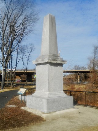
The Newkirk Viaduct Monument is a 15-foot (4.6 m) white marble obelisk in the West Philadelphia neighborhood of Philadelphia, Pennsylvania. It was installed in 1839 to mark the completion of the Newkirk Viaduct, the first permanent railroad bridge over the Schuylkill River. It is inscribed with the names of 51 railroad builders and executives, among other information.

<span class="mw-page-title-main">Philadelphia and Baltimore Central Railroad</span>

The Philadelphia and Baltimore Central Railroad (P&BC) was a railroad that operated in Pennsylvania and Maryland in the 19th and early 20th centuries. It operated a 110-mile (180 km) main line between West Philadelphia and Octoraro Junction, Maryland, plus several branch lines.

<span class="mw-page-title-main">Columbia and Port Deposit Railroad</span> Railway line in Maryland and Pennsylvania, US

The Columbia and Port Deposit Railroad (C&PD) was a railroad that operated in Pennsylvania and Maryland in the 19th and early 20th centuries. It operated a 34-mile long (55 km) main line between Columbia, Pennsylvania, and Port Deposit, Maryland, generally along the eastern shore of the Susquehanna River. It later acquired a branch line to Perryville, Maryland. The C&PD was subsequently purchased by the Pennsylvania Railroad (PRR) and, since the 1999 breakup of Conrail, is owned by Norfolk Southern Railway.

<span class="mw-page-title-main">Elkton station</span> Former railway station in Elkton, Maryland, US

Elkton station is a former passenger rail station located in Elkton, Maryland. The last passenger service to the station was Amtrak's Chesapeake from 1978 to 1983. The brick station building still remains along the Northeast Corridor tracks.

References

  1. 1 2 3 4 5 6 Roberts, Charles S.; David W. Messer (2003). Triumph VI: Philadelphia, Columbia, Harrisburg to Baltimore and Washington DC: 1827-2003. Baltimore, Maryland: Barnard, Roberts, and Co., Inc. ISBN   0-934118-28-0.
  2. 1 2 "Nautical chart for Perryville vicinity". Maptech MapServer. Retrieved December 28, 2008.[ permanent dead link ]
  3. 1 2 Baer, Christopher T. "PRR Chronology: 1906" (PDF). Archived (PDF) from the original on September 16, 2015. Retrieved June 4, 2015.
  4. 1 2 Weinberg, Harrison (November 18, 2022). "Amtrak Advances Susquehanna River Bridge Project". media.amtrak.com. Amtrak. Archived from the original on November 26, 2022. Retrieved November 25, 2022.
  5. Jeremy Steinemann (August 23, 2011). "A 21st Century NEC: The Top Four Failing Bridges that Must Be Replaced". Northeast Alliance for Rail. Archived from the original on December 8, 2022. Retrieved February 7, 2024. In May 2011, Maryland was awarded a $22 million federal, high-speed rail grant to support initial design and engineering for the Susquehanna Bridge replacement. Priced at $500 million, the bridge is the most expensive to replace in Maryland.
  6. 1 2 "Pennsy to Use the Big Bridge Today". Cecil Whig . 1906-05-26. p. 1. Archived from the original on 2023-07-01. Retrieved 2023-07-01 via Newspapers.com. Open Access logo PLoS transparent.svg
  7. Baer, Christopher T. "PRR Chronology: 1976" (PDF). Archived (PDF) from the original on September 29, 2022. Retrieved June 4, 2015.
  8. Volin, Rudy (July 6, 2006). "Hot Spots: Perryville and Havre de Grace, Md". TRAINS Magazine. Archived from the original on 4 December 2008. Retrieved December 28, 2008.
  9. Brubaker, John H. (2002). Down the Susquehanna to the Chesapeake. Penn State Press. ISBN   0-271-02184-5.
  10. "Capital Investment in Bridge Aims to Improve Reliability" (PDF). Amtrak Ink. March 2007. pp. 1–7. Archived (PDF) from the original on June 6, 2011. Retrieved December 28, 2008.
  11. U.S. Department of Transportation (May 9, 2011). "U.S. Transportation Secretary LaHood Announces $2 Billion for High-Speed Intercity Rail Projects to Grow Jobs, Boost U.S. Manufacturing and Transform Travel in America". Archived from the original on February 20, 2013. Retrieved April 30, 2013.
  12. Decker, Caroline. "Amtrak Update: CSG-ERC Executive Committee". Archived from the original on October 16, 2009. Retrieved December 28, 2008.
  13. "Susquehanna River Rail Bridge Project". Amtrak. Archived from the original on February 20, 2020. Retrieved February 19, 2020.
  14. Ready To Build: Susquehanna River Bridge. YouTube.com. Amtrak. October 4, 2017. Archived from the original on 2021-12-22. Retrieved February 19, 2020.
  15. "Fact Sheet: President Biden Advances Vision for World Class Passenger Rail by Delivering Billions in New Funding". The White House. 2023-11-06. Archived from the original on 2023-11-06. Retrieved 2023-11-06.