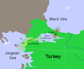
The Bosporus or Bosphorus Strait is a natural strait and an internationally significant waterway located in Istanbul, Turkey. The Bosporus connects the Black Sea to the Sea of Marmara and forms one of the continental boundaries between Asia and Europe. It also divides Turkey by separating Asia minor from Thrace. It is the world's narrowest strait used for international navigation.

Üsküdar is a municipality and district of Istanbul Province, Turkey. Its area is 35 km2, and its population is 524,452 (2022). It is a large and densely populated district on the Anatolian (Asian) shore of the Bosphorus. It is bordered to the north by Beykoz, to the east by Ümraniye, to the southeast by Ataşehir and to the south by Kadıköy; with Karaköy, Kabataş, Beşiktaş, and the historic Sarayburnu quarter of Fatih facing it on the opposite shore to the west. Üsküdar has been a conservative cultural center of the Anatolian side of Istanbul since Ottoman times with its landmark as well as numerous tiny mosques and dergahs.

Beşiktaş is a district and municipality of Istanbul Province, Turkey. Its area is 18 km2 and its population is 175,190 (2022). It is located on the European shore of the Bosphorus strait. It is bordered on the north by Sarıyer and Şişli, on the west by Kağıthane and Şişli, on the south by Beyoğlu, and on the east by the Bosphorus. Directly across the Bosphorus is the district of Üsküdar.
Beykoz is a municipality and district of Istanbul Province, Turkey. Its area is 310 km2, and its population is 247,875 (2022). It lies at the northern end of the Bosphorus on the Anatolian side. The name is believed to be a combination of the words bey and kos, which means "village" in Farsi. Beykoz includes an area from the streams of Küçüksu and Göksu to the opening of the Bosphorus into the Black Sea, and the villages in the hinterland as far as the Riva creek. Before the Turkish alphabet reform of 1928, it was sometimes Latinized variously as Beicos or Beikos.

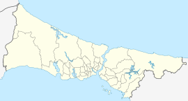
Public transport in Istanbul comprises a bus network, various rail systems, funiculars, and maritime services to serve the more than 15 million inhabitants of the city spread over an area of 5,712 km2.
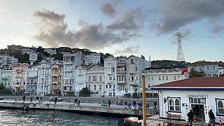
Arnavutköy is a neighbourhood in the municipality and district of Beşiktaş, Istanbul Province, Turkey. Its population is 3,574 (2022). It is renowned for its wooden Ottoman mansions and seafood restaurants, as well as for the campus of the prestigious Robert College with its historic buildings. It is part of the Beşiktaş district of Istanbul, and is located between Ortaköy and Bebek on the European shoreline of the Bosphorus strait.

A yalı is a house or mansion built right on the waterside and usually built with an architectural concept that takes into account the characteristics of the coastal location. A family who owned a waterside residence would spend some time in this usually secondary residence located at the sea shore, as opposed to the konak or the köşk. Thus, going to the "yalı" acquired the sense of both going to the seaside and to the house situated there. In its contemporary sense, the term "yalı" is used primarily to denote those 620 waterside residences constructed during the 18th, 19th, and 20th centuries and sprinkled along the Bosphorus in Istanbul. As such, they are one of the area's landmarks.
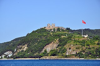
Yoros Castle is a ruined castle dating back to Byzantine times that stands above the confluence of the Bosphorus and the Black Sea, to the north of Joshua's Hill, in Beykoz district, Istanbul, Turkey. It is commonly referred to as the Genoese Castle, due to Genoa’s possession of it in the mid-15th century.

Rumeli Feneri, also Türkeli Feneri, a historical lighthouse still in use, is located on the European side of the Bosporus Strait's Black Sea entrance in Istanbul.

Ferries in Istanbul are a mode of public transportation within and surrounding the city of Istanbul, Turkey. There are three major ferry operators in the city: the municipally owned Şehir Hatları, which operates traditional vapurs; the privately operated İstanbul Deniz Otobüsleri (İDO), which operates high-speed urban and intercity services, and the privately owned Turyol which operates mostly urban services.

Kireçburnu is a neighbourhood in the municipality and district of Sarıyer, Istanbul Province, Turkey. Its population is 6,888 (2022). It is located on the northern shore of Bosphorus at European side. It is to the north of İstanbul centre with a distance over 15 kilometres (9.3 mi).

Kanlıca is a neighbourhood in the municipality and district of Beykoz, Istanbul Province, Turkey. Its population is 3,943 (2022). It is on the Asian side of the Bosphorus strait. It is known for a yogurt sprinkled with caster sugar, which is sold in local cafés.

Emirgan is a neighbourhood in the municipality and district of Sarıyer, Istanbul Province, Turkey. Its population is 8,290 (2022). It is a leafy, middle-class suburb of Istanbul, on the western shore of the Bosphorus north of the Fatih Sultan Mehmet Bridge.

Emirgan Pier is a historic passenger ferryboat pier located in Emirgan neighborhood of Sarıyer district in Istanbul Province, Turkey. It serves ferries in Istanbul running between Çengelköy and İstinye on Bosphorus.
Garipçe is a neighbourhood in the municipality and district of Sarıyer, Istanbul Province, Turkey. Its population is 391 (2022).

Rumelikavağı, also known as Rumeli Kavağı, is a neighbourhood in the municipality and district of Sarıyer, Istanbul Province, Turkey. Its population is 3,657 (2022). "Rumeli" is the Turkish name for Thrace, and "Kavak" means "control post" in Ottoman Turkish referring to the strategic position of the location on the Bosporus. The ferry pier which is the center of the neighborhood is at 41°10′54″N29°04′30″E.

Paşabahçe is a neighbourhood in the municipality and district of Beykoz, Istanbul Province, Turkey. Its population is 3,717 (2022). It is located on the Anatolian side of the Bosphorus.

Çubuklu is a neighbourhood in the municipality and district of Beykoz, Istanbul Province, Turkey. Its population is 20,698 (2022). It is on the Anatolian side of the Bosphorus. It was called Katangion in Byzantine times when it was a recreational area.
The Üsküdar Ferry Terminal, also known as the Üsküdar Pier, is a ferry terminal in Üsküdar, Istanbul, located along Paşa Limanı Avenue on the Bosporus strait. It is used by Municipal Şehir Hatları ferries as well as private Dentur ferries. Şehir Hatları ferries operate to several piers along the Bosporus and Golden Horn, while Dentur operates frequent ferry service to Kabataş and Beşiktaş.