It is the site of the ancient Greek city of Phinopolis (Greek: Φινούπολις), which was founded on an existent Thracian settlement. Sarıyer's Bosphorus villages, backed by steep hills, were once rural fishing communities. In the 18th century, palace officials and other people close to the Ottoman sultan started building their yalıs on the coastline. Around this time, wealthy foreign traders of Pera and Galata built summer residences in the area. In the beginning of the 19th century, the embassies, located in Istanbul proper, started acquiring plots of lands to build summer residences. Despite all this development, the villages remained quiet fishing towns up until the 1950s. In the 1950s and 60s, the Sarıyer villages were considered "holiday towns" for the people living in Istanbul. However, since the construction of the coast road, these villages, and increasingly the hillsides behind them, rapidly urbanized. By the 1980s, the coastal areas were full of newly built, expensive apartments, while the hillsides being built up with illegal housing called gecekondu.[4]
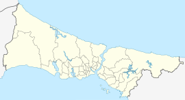
The district Sarıyer was established in 1930 from parts of the districts of Beyoğlu and Çatalca.[5] The district's boundaries shrunk after the neighbourhood of Kemerburgaz was given to the Eyüp district in 1936 and when the villages of Maslak and Ayazağa were given to Şişli district in 1954. The present boundaries of Sarıyer were created after incorporating the neighbourhoods of Maslak, Ayazağa and Huzur from the district of Şişli in 2012.[6]
Sarıyer is connected to downtown Istanbul by Büyükdere Avenue, the main road from Beşiktaş up to Maslak and beyond; this is the route used by minibuses serving Sarıyer-Beşiktaş. There is also high-speed ferry boat service for commuting to the city. The M2 metro line runs via Maslak to Hacıosman. However, many people commute by car, contributing to the heavy traffic congestion.
Sarıyer itself is a traditional working-class Turkish town, lacking in infrastructure. The industry feeds the local fish market and a long line of famous fish restaurants. There are also a variety of cafés, kebab houses and bars, where many of İstanbul's residents come to eat and drink on weekends.
Emirgan is former retreat from the city, backed by a hillside still green despite the recent construction of villas within it. The district is named after Emir Güne Han, a Persian nobleman who was given 50 hectares of land in the area in 1635 by Murad IV after he surrendered Yerevan without a fight. There is a square in the center, shaded by a huge plane tree, with a cafe in the middle. It is home to the Sakıp Sabancı Museum. Emirgan Korusu, which hosts the Emirgan Tulip Festival annually, is also located in the neighborhood.[8]
Reşitpaşa is a crowded district on the hill above Emirgan. It has both attractive villas and illegal gecekondu housing on a forested hillside. The modern campus of the Istanbul Stock Exchange is nearby, along with one of the campuses of Istanbul Technical University.
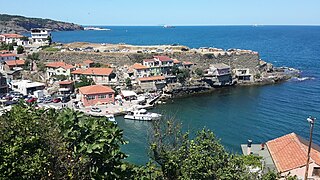
Istinye is a fishing port, which once contained a shipyard, with a village behind and tea gardens by the sea. As in so many other areas, luxury condos now rise from Istinye's hillsides. In 2003 the new American consulate was built here. One of Istanbul's most popular malls, Istinye Park, is named after the neighborhood but is actually located in the neighboring Pınar.
Yeniköy consists of luxury villas on a hillside and a small area of tightly packed old houses near the sea. The latter area, the old village, has a longstanding Greek community, evidenced by its Orthodox churches. Yeniköy has many long-established cafes and bakeries reminiscent of old Istanbul. Former prime minister Tansu Çiller lives in a town-house on the seafront. In recent years Yeniköy has acquired a community of Filipinos, working as domestic help in the big villas.
Tarabya was formerly the GreekTheràpia, the name of which comes from the Greek word therapeia (therapy) and indicates the area's former use as a sanctuary from the city for the sick. It is now an affluent neighbourhood, dominated by the once grand Tarabya Hotel. There are fish restaurants and 'taverna' featuring traditional Turkish music, drink, and atmosphere. Marmara University has a small site here, teaching French, housed in a villa built by Alexander Ypsilantis. A stream once flowed to the Bosphorus, but is now covered by concrete. Tarabya also is home to the German consulate.
Büyükdere was formerly the Greek-ByzantineVathys Kòlpos District, 'the deep gulf' in Greek. It was originally a residential area composed mostly of old, quiet neighborhoods. However, recent years have seen the construction of expensive apartments and condominiums. Home to a number of churches, the Spanish and Russian summer consulates and the Sadberk Hanım Museum. The area is also known for its börek.
Bahçeköy was formerly the ByzantinePetra district. It is one of the northern villages of Sarıyer. After Suleiman the Magnificent came back from Belgrade, he settled the Serbs in the nearby forest, which has since been known as the "Belgrade" Forest (Belgrad Ormanı.) In the 19th century, the village was inside the Belgrad Forest but due to the latter's retreat before development, Bahçeköy now sits on the forest's edge. Atatürk Arboretum is in Bahçeköy.
At one time, the Ottoman military would use the Belgrad Forest for military exercises. Today it is popular for picnics at the weekend, and the road to Kilyos passes through here. The woods are home to Istanbul University's department of forestry, and are accessible by public transport. There have always been rural communities here but since the 1990s, luxury housing and private schools have been built in parts of the forest. The largest of these developments is the new village of Zekeriyaköy, which is now one of the most expensive residential areas in Istanbul. The campus of the Koç University is also located in the forest. The growth of these areas may have, along with construction and poorly conceived traffic flow planning, contributed to the heavy traffic in the village of Sarıyer.
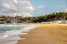
Kilyos is a small town, a summer retreat from the city, although it is often windswept in winter. Some Istanbul residents swim in the sea at Kilyos, although the rocky coast and strong currents, including, in places, a dangerous undertow, make swimming here risky. The road to Kilyos leads through the Belgrad Forest with its system of viaducts and reservoirs going back to the Ottoman period, although it is also accessible through the village of Sarıyer, leading to serious traffic delays during summer months. In recent years Kilyos has acquired a number of bars and cafés, including a couple of well-known private beach clubs and a rock festival in summer.
Climate
Sarıyer's climate, typical of northern Istanbul, is oceanic(Cfb/Do) according to both Köppen and Trewartha climate classifications, with cool winters and warm summers. Sarıyer's climate is marked by high precipitation (the highest annual precipitation in Istanbul), milder summers and slightly colder winters than most of lowland Istanbul. It is classified as USDA hardiness zone 8b with pockets of 8a, and AHS heat zone 3.[9]
Climate data for Bahçeköy, Istanbul (normals 1981–2010, snowy days 1990-1999)
Beşiktaş is a district and municipality of Istanbul Province, Turkey. Its area is 18 km2 and its population is 175,190 (2022). It is located on the European shore of the Bosphorus strait. It is bordered on the north by Sarıyer and Şişli, on the west by Kağıthane and Şişli, on the south by Beyoğlu, and on the east by the Bosphorus. Directly across the Bosphorus is the district of Üsküdar.
Koç University is a private non-profit research university in Istanbul, Turkey. It started education in temporary buildings in İstinye in 1993, and moved to its current Rumelifeneri campus near Sarıyer in 2000. Koç University is ranked highest in Turkey according to the 2022 Times Higher Education World University Rankings and 2022 QS World University Rankings. Koç University currently consists of Colleges of Social Sciences and Humanities, Administrative Sciences and Economics, Science, Engineering, Law, Nursing and Medicine. Koç University offers 22 undergraduate, 43 master's and 30 Ph.D. programs. The university is home to more than 8,000 students. The university accepts international students from various countries and has an extensive network of over 250 partner-universities including the University of California, Northwestern University, Cornell University and Georgetown University.
Levent is a neighbourhood in the municipality and district of Beşiktaş, Istanbul Province, Turkey. Its population is 2,911 (2022). It is one of the main business districts of Istanbul located on the European side of the city. It is situated to the north of the Golden Horn, at the western shore of the Bosphorus strait.
Maslak is a neighbourhood in Sarıyer, Istanbul Province, in Turkey. Its population is 12,260 (2022). It is one of the main business districts of Istanbul, located on the European side of the city. It was formerly an exclave of the municipality of Şişli, though being far north and actually closer to the municipalities of Sarıyer and Beşiktaş. In 2012, the jurisdiction of the Maslak district was shifted from Şişli to Sarıyer.
İstinye is a neighbourhood in the municipality and district of Sarıyer, Istanbul Province, Turkey. Its population is 15,721 (2022). It is on the European side of the city. It is located between the neighbourhoods of Emirgan and Yeniköy, on the northwestern shore of the Bosporus strait. It is one of the finest seashore locations on the Bosporus where people walk around during the weekends. İstinye is famous for its cafés and seafood restaurants. A small bay is also among the things that make İstinye a preferred location to visit.
Tarabya is a neighbourhood in the municipality and district of Sarıyer, Istanbul Province, Turkey. Its population is 17,852 (2022). It is located on the European shoreline of the Bosphorus strait, between the neighbourhoods of Yeniköy and Kireçburnu. It is famous for its coastal fish restaurants. Lycée Français Pierre Loti d'Istanbul and Tarabya British Schools both have high school campuses in Tarabya.
Boğaziçi is the general term, specific to Istanbul and overlapping administrative divisions, used to denote those parts of the city with a view of the Bosphorus. The respective nuances of the two terms being somewhat similar to those between San Francisco Bay and the Bay Area, they are not used interchangeably in correct parlance.
Yeniköy, known in Greek as Neochorion, Neochori (Νεοχώρι), or Nichori, sometimes also referred to as Yeni Kioi, is a neighbourhood in the municipality and district of Sarıyer, Istanbul Province, Turkey. Its population is 14,963 (2022). It is located on the European shores of the Bosphorus strait, between the neighbourhoods of İstinye and Tarabya.
The British International School Istanbul (BISI) is a private international primary and secondary school in Istanbul, Turkey, offering a modified English National Curriculum, IGCSE and the International Baccalaureate Diploma Programme. The school comprises three campuses: a city campus in Etiler, Beşiktaş, serving preschool and primary students; a campus in Zekeriyaköy, Sarıyer, accommodating students from preschool to secondary education, including sixth form; and a campus in Bahçeşehir, Başakşehir, providing education at the preschool, primary, and middle school levels. The school is a co-educational community. The student body represents over 55 nationalities, with ages ranging from 2½ to 18 years. As a private international institution, the school prepares its graduates for higher education, with many pursuing university studies. Graduates frequently pursue higher education at institutions in the United Kingdom and the United States.
Belgrad Forest is a mixed deciduous forest lying adjacent to Istanbul, Turkey. It is named after the village next to the forest, settled by thousands of Serbs who were deported to the capital Constantinople from the city of Belgrade in 1521, when it fell to the Ottomans. Geographically, the forest is located at the easternmost point of the Thracian Peninsula. Forest terrain is divided between Sarıyer and Eyüp districts. Several historical reservoirs lie within the forest.
Büyükdere Avenue is a major avenue which runs through the districts of Şişli, Beşiktaş and Sarıyer on the European side of Istanbul, Turkey. It begins at Şişli Mosque and runs in an eastward direction partly under the viaduct of the inner-city motorway O-1 through Mecidiyeköy, Esentepe, until reaching Zincirlikuyu; where it joins with Barbaros Boulevard and turns northward passing through Levent, Sanayi Mahallesi, Maslak and by the Fatih Forest, ending at the Hacıosman Slope on the Sarıyer district border. Its total length is 14 km (8.7 mi). From Zincirlikuyu to Maslak, it forms a border line between the districts of Kağıthane in the east and Beşiktaş in the west. It is named after the Büyükdere neighborhood of Sarıyer district, where it connects to. It is a major artery of the Istanbul Central Business District, which is not located in the historic center of the city.
Büyükdere is a neighbourhood in the municipality and district of Sarıyer, Istanbul Province, Turkey. Its population is 8,586 (2022). It is situated on the European shore of the Bosphorus strait about 2 km (1.2 mi) southwest of Sarıyer. Its name means 'big stream' in Turkish, in reference to the river that used to flow into the Bosphorus here.
Bahçeköy or Bahçeköy Merkez is a neighbourhood in the municipality and district of Sarıyer, Istanbul Province, Turkey. Its population is 3,737 (2022).
Valide Dam is a historic dam located in Sarıyer district of Istanbul Province, Turkey.
Emirgan is a neighbourhood in the municipality and district of Sarıyer, Istanbul Province, Turkey. Its population is 8,290 (2022). It is a leafy, middle-class suburb of Istanbul, on the western shore of the Bosphorus north of the Fatih Sultan Mehmet Bridge.
Garipçe is a neighbourhood in the municipality and district of Sarıyer, Istanbul Province, Turkey. Its population is 391 (2022).
Kömürcübent Nature Park is a nature park located in Sarıyer district of Istanbul Province, Turkey.
Irmak Nature Park is a nature park located in Sarıyer district of Istanbul Province, Turkey.
Istanbul's Central Business District as the real estate industry refers to it, is not the historic city center, but a 7-km-long north–south corridor of modern areas mostly along Barbaros Boulevard and Büyükdere Avenue. As of late 2021, 33% of the Class A office space in the metropolitan area was located in the CBD, of which about 790,000 sqm in Maslak, 690,000 sqm in Levent, 500,000 sqm in Zincirlikuyu/Esentepe/Gayrettepe and 100,000 sqm in Etiler.
↑ "ContactArchived 2019-09-20 at the Wayback Machine ." Lycée Français Pierre Loti d'Istanbul. Retrieved on 20 February 2015. "Adresse: Haydar Aliyev Caddesi n°128" and "Adresse: Tomtom Kaptan Sok. Beyoğlu"
↑ "Contact Us". Tarabya British Schools. Retrieved 2019-07-09.
This page is based on this Wikipedia article Text is available under the CC BY-SA 4.0 license; additional terms may apply. Images, videos and audio are available under their respective licenses.