Isparta Province

Last updated
Isparta Province
Isparta ili
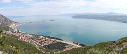
Lake Egirdir.jpg
Isparta in Turkey.svg
Location of the province within Turkey
Country Turkey
Seat Isparta
Government
 •  Governor Aydın Baruş
Area
8,946 km2 (3,454 sq mi)
Population
 (2024) [1]
449,777
 • Density50.28/km2 (130.2/sq mi)
Time zone UTC+3 (TRT)
Area code 0246
Website www.isparta.gov.tr

Isparta Province (Turkish : Isparta ili) is a province in southwestern Turkey. Its adjacent provinces are Afyon to the northwest, Burdur to the southwest, Antalya to the south, and Konya to the east. Its area is 8,946 km2, [2] and its population is 445,325 (2022). [1] The provincial capital is Isparta.

Contents

The province is well known for producing apples, sour cherries, grapes, roses and rose products, [3] and carpets. The best fertile lands are in Uluborlu. The province is situated in the Göller Bölgesi (Lakes Area) of Turkey's Mediterranean Region and has many freshwater lakes. [4]

Districts

Isparta location districts.png

Isparta province is divided into 13 districts (capital district in bold):

Geography

Isparta lies in the northernmost part of the Pamphylian basin, wedged between the continental Bey Dağları and Anatolian blocks. [5] : 134  This area is known as the Isparta Angle. [5] : 134  The Isparta Angle is a result of the Anatolian Plate's rotation from the early Paleocene to the early Pliocene, and is a very seismically active area as a result. [6]

Economy

As of 2012, there are 178,162 hectares of agricultural land in Isparta province, of which 28.8% (37,184 ha) is used for fruit growing. [7] : 5 

Isparta province accounts for 23.4% of all apple production in Turkey as of 2012. [7] : 5  The majority of the province's apple production is done in three districts: Eğirdir, Gelendost, and Senirkent. [7] : 5  Together, these three districts account for 73.2% of the province's apple production. [7] : 5 

Notable people

See also

References

  1. 1 2 "Address-based population registration system (ADNKS) results dated 31 December 2022, Favorite Reports" (XLS). TÜİK . Retrieved 19 September 2023.
  2. ↑ "İl ve İlçe Yüz ölçümleri". General Directorate of Mapping. Retrieved 19 September 2023.
  3. ↑ "ISPARTA GÜLÜ". Kültür Portalı. Retrieved 2024-02-21.
  4. ↑ Özalp, Ayşegül Parlayan (2015-11-30). "Göller Yöresi; Anadolu'nun Gözleri – Atlas" (in Turkish). Retrieved 2024-02-21.
  5. 1 2 Poisson, André; Orszag-Sperber, Fabienne; Kosun, Erdal; Bassetti, Maria-Angella; Müller, Carla; Wernli, Roland; Rouchy, Jean-Marie (May 2011). "The Late Cenozoic evolution of the Aksu basin (Isparta Angle; SW Turkey). New insights". Bulletin de la Société Géologique de France. 182 (2): 133–48. doi:10.2113/gssgfbull.182.2.133 . Retrieved 10 February 2023.
  6. ↑ Şahin, Şakir; Abubakar, Ibrahim; Özçelik, Mehmet; Abdelwahed, Mohamed Farouk; Oksum, Erdinç (2019). "Neotectonic structures imaged by seismic velocity along the Isparta Angle". Arabian Journal of Geosciences. 12. Retrieved 10 February 2023.
  7. 1 2 3 4 Yilmaz, Hasan (2014). "Analysis in terms of apple producers of government supported crop insurance policies as a risk management tool in Turkey". Acta Scientiarium Polonorum, Hortorum Cultus. 13 (5): 3–12. Retrieved 10 February 2023.

37°57′24″N30°57′39″E / 37.95667°N 30.96083°E / 37.95667; 30.96083