Kastamonu Province is a province of Turkey, in the Black Sea region in the north of the country. It is surrounded by Sinop to the east, Bartın, Karabük to the west, Çankırı to the south, Çorum to the southeast and the Black Sea to the north. Its area is 13,064 km2, and its population is 378,115 (2022). The population density is 29 inhabitants per km2. The provincial capital Kastamonu has a population of 128,707 (2022).

Bolu Province is a province situated in north-western Turkey. It is located between the capital, Ankara, and the largest city in the country, Istanbul. Its area is 8,313 km2, and its population is 320,824 (2022). The capital city of the province is Bolu.

Bartın Province is a small province in northern Turkey on the Black Sea, surrounding the city of Bartın. Its area is 2,330 km2, and its population is 203,351 (2022). It lies to the east of Zonguldak Province.

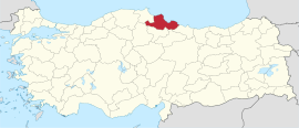
Samsun, historically known as Sampsounta and Amisos, is a city on the north coast of Turkey and a major Black Sea port. Over 700,000 people live in the city. The city is the capital of Samsun Province which has a population of over 1,350,000. The city is home to Ondokuz Mayıs University, several hospitals, three large shopping malls, Samsunspor football club, an opera house and a large and modern manufacturing district. A former Greek settlement, the city is best known as the place where Mustafa Kemal Atatürk began the Turkish War of Independence in 1919.

Burdur Province is a province of Turkey, located in the southwest and bordering Muğla and Antalya to the south, Denizli to the west, Afyon to the north, and Isparta to the east. Its area is 7,175 km2, and its population is 273,799 (2022). The provincial capital is Burdur city.
Denizli Province is a province and metropolitan municipality of Turkey in Western Anatolia, on high ground above the Aegean coast. Neighbouring provinces are Uşak to the north, Burdur, Isparta, Afyon to the east, Aydın, Manisa to the west and Muğla to the south. It is located between the coordinates 28° 30’ and 29° 30’ E and 37° 12’ and 38° 12’ N. Its area is 12,134 km2, and its population is 1,056,332 (2022). The provincial capital is the city of Denizli.

Ordu Province is a province and metropolitan municipality of Turkey, located on the Black Sea coast. Its area is 5,914 km2, and its population is 763,190 (2022). Its adjacent provinces are Samsun to the northwest, Tokat to the southwest, Sivas to the south, and Giresun to the east. Its license-plate code is 52. The capital of the province is the city of Ordu.

Manisa Province is a province and metropolitan municipality in western Turkey. Its area is 13,339 km2, and its population is 1,468,279 (2022). Its neighboring provinces are İzmir to the west, Aydın to the south, Denizli to the southeast, Uşak to the east, Kütahya to the northeast, and Balıkesir to the north. The city of Manisa is the seat and capital of the province. The traffic code is 45.
Isparta Province is a province in southwestern Turkey. Its adjacent provinces are Afyon to the northwest, Burdur to the southwest, Antalya to the south, and Konya to the east. Its area is 8,946 km2, and its population is 445,325 (2022). The provincial capital is Isparta.
Aksaray Province is a province in central Turkey. Its adjacent provinces are Konya along the west and south, Ankara to the northwest, Niğde to the southeast, Nevşehir to the east, and Kırşehir to the north. Its area is 7,659 km2, and its population is 433,055 (2022). The provincial capital is the city of Aksaray.
Kırşehir Province is a province in central Turkey, forming part of the Central Anatolia Region. Its area is 6,584 km2, and its population is 244,519 (2022). It stands on the North Anatolian Fault, and is currently in an earthquake warning zone. The average elevation is approximately 985 meters above sea level. The provincial capital is Kırşehir. The geographical centre of all land surfaces on Earth is at 39°00′N34°00′E, in Kırşehir Province, Turkey.
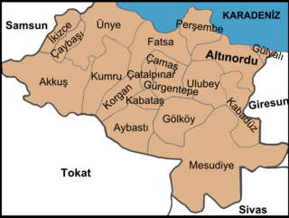
Kabataş, formerly Karay, is a municipality and district of Ordu Province, Turkey. Its area is 74 km2, and its population is 10,119 (2022). The town lies at an elevation of 450 m (1,476 ft).

Sarayönü is a municipality and district of Konya Province, Turkey. Its area is 1,620 km2, and its population is 27,771 (2022). The town occupies the location of the ancient Laodicea Combusta.

Ladik is a municipality and district of Samsun Province, Turkey. Its area is 541 km2, and its population is 16,072 (2022). It is on the site of the ancient Laodicea Pontica. The mayor is Adnan Topal (AKP).

Terme is a municipality and district of Samsun Province, Turkey. Its area is 548 km2, and its population is 71,092 (2022). Terme is located on Terme River, about 5 km from its mouth, on the eastern end of the Çarşamba Plain.

Bottomland forest is woodland on lowland alluvial floodplains or lower terraces of rivers and streams. Bottomland forest is very rare in Europe. The bottomland hardwood forest is a type of deciduous and evergreen hardwood forest found in broad lowland floodplains along large rivers and lakes in the United States and elsewhere. They are occasionally flooded, which builds up the alluvial soils required for the gum, oak and bald cypress trees that typically grow in this type of biome. The trees often develop unique characteristics to allow submergence, including cypress knees and fluted trunks, but can not survive continuous flooding.

Ilkadim is a municipality and district of Samsun Province, Turkey. Its area is 155 km2, and its population is 333,518 (2022). It is located on the coast of Black Sea. The district has an altitude of 5 meters.It is also the most populous district of Black Sea Region. The majority of the urbanized portion of Samsun City is located within İlkadım.

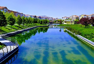
Atakum is a municipality and district of Samsun Province, Turkey. Its area is 351 km2, and its population is 242,171 (2022). Atakum is a largely middle class suburban district located to the west of the primary city of Samsun and further suburban Ondokuzmayıs. The city's population expanded rapidly beginning in the 1990s and continues to grow at a healthy pace. The city consists largely of middle class housing blocks with ground floor retail and a mix of office uses. In 2009, the city undertook a significant waterfront redevelopment campaign which entailed the construction of a beachfront and pedestrian promenade. Construction of the waterfront promenade and Tram was led by former Samsun Province governor Yusuf Ziya Yılmaz. The city is served by the Samsun Tram which runs down the median of İsmet İnönü Caddesi.

Sinop Province is a province of Turkey, along the Black Sea. It is located between 41 and 42 degrees North latitude and between 34 and 35 degrees East longitude. Its area is 5,717 km2, equivalent to 0.73% of Turkey's total area, and its population is 220,799 (2022). The borders total 475 km and consists of 300 km of land and 175 km seaside borders. Its adjacent provinces are Kastamonu on the west, Çorum on the south, and Samsun on the southeast.

Samsun Clock Tower is the tower that gives its name to Samsun Saathane Square located in Ilkadim district of Samsun.