
Dursunbey, formerly Balat, is a municipality and district of Balıkesir Province, Turkey. Its area is 1,719 km2, and its population is 33,333 (2022). The mayor is Ramazan Bahçavan (AKP). Dursunbey is noted for its wood and apples.

Köşk is a municipality and district of Aydın Province, Turkey. Its area is 187 km2, and its population is 28,235 (2022). "Köşk" is a noun in Turkish and refers to an ornate wooden mansion, smaller than a palace.
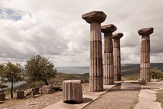
Ayvacık is a town in Çanakkale Province in the Marmara region of Turkey. It is the seat of Ayvacık District. Its population is 9,710 (2021). The town lies at an elevation of 252 m (827 ft). During the Gallipoli campaign in World War I, it was the target of several allied attacks.

Asarcık is a municipality and district of Samsun Province, Turkey. Its area is 253 km2, and its population is 16,001 (2022).

Büyükorhan is a municipality and district of Bursa Province, Turkey. Its area is 505 km2, and its population is 8,940 (2022).

Karaçoban is a municipality and district of Erzurum Province, Turkey. Its area is 571 km2, and its population is 22,250 (2022).

Köprüköy, is a municipality and district of Erzurum Province, Turkey. Its area is 777 km2, and its population is 14,204 (2022). The mayor is Osman Belli (AKP).

Saimbeyli, alternatively known as Hadjin, is a town and district of Adana Province, Turkey. Its area is 989 km2, and its population is 13,621 (2022). The town is located at the Taurus mountains of Cilicia region, 157 km north of the city of Adana.

Çameli is a municipality and district of Denizli Province, Turkey. Its area is 758 km2, and its population is 17,549 (2022). It is a wooded highland area at the western end of the Taurus Mountains.

Kızılcahamam is a municipality and district of Ankara Province, Turkey. Its area is 1,623 km2, and its population is 26,872 (2022). It is 70 km north of the city of Ankara, near the motorway to Istanbul. Its elevation is 975 m. The area is mountain and forest, a geographical boundary between central Anatolia and the Black Sea regions.

Çat is a municipality and district of Erzurum Province, Turkey. Its area is 1,448 km2, and its population is 15,556 (2022). The mayor is Melik Yaşar (AKP).

Sultangazi is municipality and district of Istanbul Province, Turkey. Its area is 37 km2, and its population is 542,531 (2022). To the west are the neighbourhoods of Esenler and Başakşehir, Gaziosmanpaşa is to the south and Eyüpsultan is to the north and east. One border of the district is formed by the TEM highway.
Çekmeköy is a municipality and district of Istanbul Province, Turkey. Its area is 152 km2, and its population is 296,066 (2022). It is on the Asian side of Istanbul.

Aziziye is a municipality and district of Erzurum Province, Turkey. Its area is 1,529 km2, and its population is 65,553 (2022).

Altıeylül is a municipality and district of Balıkesir Province, Turkey. Its area is 956 km2, and its population is 183,736 (2022).

Hamur District is a district of Ağrı Province of Turkey. Its seat is the town Hamur. Its area is 873 km2, and its population is 17,106 (2021).
Bilecik District is a district of Bilecik Province of Turkey. Its seat is the city of Bilecik. Its area is 793 km2, and its population is 86,442 (2021).

Ayvacık District is a district of the Çanakkale Province of Turkey. Its seat is the town of Ayvacık. Its area is 880 km2, and its population is 34,103 (2021).

Şaphane District is a district of the Kütahya Province of Turkey. Its seat is the town of Şaphane. Its area is 229 km2, and its population is 5,695 (2022).

Durağan District is a district of the Sinop Province of Turkey. Its seat is the town of Durağan. Its area is 995 km2, and its population is 16,832 (2022).


