Its correct formal title is Desa Pekraman Anggabaya (in the Balinese language) or Desa Adat Anggabaya (in the Indonesian language). In English it would be The Traditional (or Customary) Village of Anggabaya. Desa = Village. NB. Pekraman is also spelt Pakraman - both spellings are equally to be found in use.
In common parlance it is usually referred to as Banjar Anggabaya (a Banjar is more or less the same as a Parish), or just simply Anggabaya.
Location
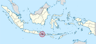
It is located approximately 4½ miles north of the centre of Denpasar, the provincial capital of Bali, and is situated on Jalan Trenggana (Trenggana Road). The nearest villages are Pelagan to the south, Jenah to the south-west, Cengkilung to the north-west and Jabajero to the east. A small river, known locally as Tukad Anggabaya, flows down from the north through the eastern part of the village, separating the hamlet of Jungut from the rest of the village.
The Village
In 2006 there were 157 households in the village with a total of 800 inhabitants. About 75% of the adults were then involved in farming, 20% in the handicraft industry and the remainder worked as civil servants, traders or in other professions.[1]
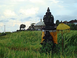
Anggabaya Temple Tower
In the village one finds a traditional market with a large Banyan tree, Pasar Kertha Waringin Sari (pasar = market, waringin = Banyan). This market was one of three Balinese traditional markets used as a subject for a postgraduate research thesis.[2] Next to the market is one of the village's 3 Balinese Hindu temples, and across the road is a large wantilan (open sided village meeting hall). The village primary school is SDN No.3 Penatih - Sekolah Dasar Negeri No.3 Penatih - National Elementary School No.3 Penatih. The school is situated about 250 yds south of the village market.
The village doctor holds a private surgery 6 evenings a week next to the primary school. In addition, medical and dental cover is provided each morning 6 days a week at the local Community Health Centre, Puskesmas II (Pusat Kesehatan Masyarakat = Community Health Centre) which is located 1.3 miles SE of Anggabaya in Jalan Nagasari, Laplap.[3]
Administration
Anggabaya is one of the 10 Banjar that make up Kelurahan Penatih.[4] A Kelurahan is local government division more or less the same as a Borough. In turn, Penatih is one of the 11 Kelurahan and/or Desa that make up the Kecamatan (or District) of Denpasar Timur (East Denpasar).[5] The Post Code for all of Penatih, and therefore for Anggabaya as well, is 80238.[6]
Telephone numbers in North-East Denpasar, which includes all of Penatih and Anggabaya, have 6 digits starting with 46 and use the Denpasar Area Code (0361), like this: (0361) 46xxxx.
Subak
Subak is the traditional Balinese system of irrigation. It is organised amongst (rice) farming communities and controls the distribution of water, especially at rice planting time. In March 2010 Subak Anggabaya had 162 members and covered an area of 39.54 hectares.[7]
In 2009 Subak Anggabaya was chosen as the beneficiary of the Denpasar City Government's Consolidation Farm Programme to assist rural farmers who were experiencing high fertilizer and seed prices coupled with low prices for harvested rice.[8] In 2010 Subak Anggabaya was chosen as the beneficiary of a Denpasar City Government Programme to build a 5km "Farmers' Trail" or access road in the subak.[9]
Subak Anggabaya is notable in that it has been used a subject for research by various postgraduates for their theses[10][11] and by other researchers for technical papers.[12]
Climate
Anggabaya has two seasons, rainy and dry. The rainy season runs from about November to April and the dry season from about May to October.
The temperature is around 86°F (30°C) by day and 79°F (26°C) by night. It does not vary much throughout the year, although in the dry season the temperature is one or two degrees cooler than in the rainy season.[13]
↑ Structure of East Denpasar Kecamatan.. This webpage shows 4 tables of numbers. The 4th table shows the numbers of males, females and then the total of inhabitants for each of the 11 Kelurahan/Desa in East Denpasar. Penatih is shown as having 5,557 inhabitants. Official website for the City of Denpasar.
Bali is a province of Indonesia and the westernmost of the Lesser Sunda Islands. East of Java and west of Lombok, the province includes the island of Bali and a few smaller offshore islands, notably Nusa Penida, Nusa Lembongan, and Nusa Ceningan to the southeast. The provincial capital, Denpasar, is the most populous city in the Lesser Sunda Islands and the second-largest, after Makassar, in Eastern Indonesia. Denpasar metropolitan area is the extended metropolitan area around Denpasar. The upland town of Ubud in Greater Denpasar is considered Bali's cultural centre. The province is Indonesia's main tourist destination, with a significant rise in tourism since the 1980s, and becoming an Indonesian area of overtourism. Tourism-related business makes up 80% of the Bali economy.
Denpasar is the capital city of the province of Bali, Indonesia. Denpasar is the main gateway to the Bali island, the city is also a hub for other cities in the Lesser Sunda Islands.
Ubud is a town on the Indonesian island of Bali in Ubud District, located amongst rice paddies and steep ravines in the central foothills of the Gianyar regency. Promoted as an arts and culture centre, it has developed a large tourism industry. It forms a northern part of the Greater Denpasar metropolitan area.
Mataram is a city and the capital of the Indonesian province of West Nusa Tenggara. The city is surrounded on all the landward sides by West Lombok Regency and lies on the western side of the island of Lombok, Indonesia. It is also the largest city of the province, and had a population of 402,843 at the 2010 Census and 429,651 at the 2020 Census; the official estimate as at mid 2023 was 441,147.
Kuta is a tourist area, administratively an urban village (kelurahan), and the capital of Kuta District, Badung Regency, southern Bali, Indonesia. Kuta is a part of the Denpasar metropolitan area, 12 km (7.5 mi) south of downtown Denpasar. Originally known as a fishing village, it was one of the first towns on Bali to see substantial tourism, and as a beach resort remains one of Indonesia's major tourist destinations. It is known internationally for its long sandy beach, varied accommodations, restaurants and bars, and many renowned surfers who visit from Australia. It is near Bali's Ngurah Rai Airport.
Subak is the water management (irrigation) system for the paddy fields on Bali island, Indonesia. It was developed in the 9th century. For the Balinese, irrigation is not simply providing water for the plant's roots, but water is used to construct a complex, pulsed artificial ecosystem that is at the same time autonomous and interdependent. The system consists of five terraced rice fields and water temples covering nearly 20,000 hectares. The temples are the main focus of this cooperative water management, known as subak.
Klungkung Regency is the smallest regency (kabupaten) in the island province of Bali, Indonesia. It has an area of 315 km2 and had a population at the 2010 Census of 170,543 which increased to 206,925 at the Census of 2020; the official estimate as at mid 2022 was 214,012. The administrative centre for the regency is in the town of Semarapura.
Buleleng, officially Buleleng Regency, is a regency of Bali Province, Indonesia. It stretches along the north side of the island of Bali from the Bali Strait in the west almost to the eastern end of the island. It has an area of 1,365.88 km2 and a population of 624,125 at the 2010 census and 791,910 at the 2020 census; the official estimate as of mid-2022 was 825,141. Its regency seat is in the town of Singaraja.
Gianyar is a regency (kabupaten) in the Indonesian province and island of Bali, Indonesia. It has an area of 368.0 km2 and had a population of 469,777 at the 2010 Census, and 515,344 at the 2020 Census, making it the second most densely populated district in Bali ; the official estimate as of mid-2022 was 523,973 - comprising 262,708 males and 261,264 females. Its regency seat is the town of Gianyar. The civil registry survey of April 2011 listed 480,447 people, of which 469,929 were classified as Hindu.
Tabanan is one of the regencies (kabupaten) in Bali, Indonesia. Relatively underdeveloped, Tabanan Regency has an area of 839.33 km2 and had a population of 386,850 in 2000, rising to 420,913 in 2010, then 461,630 at the 2020 census; the official estimate as at mid 2022 was 469,340. Its regency seat is the town of Tabanan. One of the popular tourism attractions located in Tabanan is the offshore rocky islet of Tanah Lot.
The Dutch conquest of South Bali in 1906 was a Dutch military intervention in Bali as part of the Dutch colonial conquest of the Indonesian islands, killing an estimated 1,000 people. It was part of the final takeover of the Netherlands East-Indies and the fifth Dutch military intervention in Bali. The campaign led to the deaths of the Balinese rulers of Badung and Tabanan kingdoms, their wives and children and followers. This conquest weakened the remaining independent kingdoms of Klungkung and Bangli, leading to their invasion two years later.
Kintamani is a district (kecamatan), and a village within that district, on the western edge of the larger caldera wall of the Mount Batur caldera in Bali, Indonesia. It is on the same north–south road as Penelokan and has been used as a stopping place to view the Mount Batur region. Kintamani is also known for Pura Tuluk Biyu's 1,000-year-old "Rites of Peace" stone tablets and the Kintamani dog breed. It is situated next to Mount Batur. Kintamani many inhabited by native Balinese people, Bali Aga.
Badung is a regency of Bali, Indonesia. Its regency seat is in the upland town of Mangupura. It covers districts to the west of the provincial capital of Denpasar, and it has a land area of 418.52 km2.
Way Kanan Regency is a landlocked regency (kabupaten) of Lampung Province, Sumatra, Indonesia. It was created on 20 April 1999 from what were formerly the northern and northwestern districts of North Lampung Regency. It has an area of 3,921.63 km2 and had a population of 406,123 at the 2010 census and 473,575 at the 2020 census; the official estimate as at mid 2023 was 489,773. The administrative centre lies at the town of Blambangan Umpu.
Mangku Muriati is a traditional-style Balinese painter and priestess from Kamasan village near Klungkung, Bali, Indonesia.
Omed-omedan, also known as "The Kissing Ritual", is a ceremony that is held by the young people of Banjar Kaja Sesetan, Denpasar, Bali. Omed-omedan is held on the day of ngembak geni to celebrate the Saka new year. The name is derived from the Balinese language and means pull-pull.
Tipat cantok is a Balinese popular local dish. It is made of various boiled or blanched vegetables with ketupat rice cake, served in spicy peanut sauce. In the Balinese language tipat means ketupat, while cantok means grounding ingredients using mortar and pestle. Vegetables normally used in this dish are asparagus bean, beansprout, water spinach, and tofu. It is a common street food, popular among tourists as well as locals.
Pura Taman Ayun is a compound of Balinese temple and garden located in Mengwi district (kecamatan) in Badung Regency, Bali, Indonesia. Its water features are an integral part of the local subak system.
This page is based on this Wikipedia article Text is available under the CC BY-SA 4.0 license; additional terms may apply. Images, videos and audio are available under their respective licenses.