
Sarmizegetusa Regia, also Sarmisegetusa, Sarmisegethusa, Sarmisegethuza, Ζαρμιζεγεθούσα (Zarmizegethoúsa) or Ζερμιζεγεθούση (Zermizegethoúsē), was the capital and the most important military, religious and political centre of the Dacians before the wars with the Roman Empire. Erected on top of a 1200 m high mountain, the fortress, comprising six citadels, was the core of a strategic defensive system in the Orăștie Mountains.
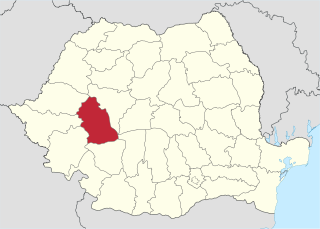
Hunedoara County is a county (județ) of Romania, in Transylvania, with its capital city at Deva. The county is part of the Danube–Criș–Mureș–Tisa Euroregion.

Orăștie is a city in Hunedoara County, south-western Transylvania, Romania.

The Mureș is a 789-kilometre-long (490 mi) river in Eastern Europe. Its drainage basin covers an area of 30,332 km2 (11,711 sq mi). It originates in the Hășmașu Mare Range in the Eastern Carpathian Mountains, Romania, rising close to the headwaters of the river Olt, and joins the Tisza at Szeged in southeastern Hungary. In Romania, its length is 761 km (473 mi) and its basin size is 27,890 km2 (10,770 sq mi).
The Vaidei is a left tributary of the river Mureș in Romania. It discharges into the Mureș near Geoagiu. Its length is 14 km (8.7 mi) and its basin size is 26 km2 (10 sq mi).
The Ghimbășel is a left tributary of the river Bârsa in Romania. Its source is in the northern part of the Bucegi Mountains. Originally it discharged directly into the Olt, but much of its flow has been diverted into the Bârsa, another tributary of the Olt, near Colonia Bod. Its length is 67 km (42 mi) and its basin size is 533 km2 (206 sq mi). The former lower course of the Ghimbășel, downstream of this diversion, still exists and is used for the discharge of local inflows. It flows into the Olt north of Bod. Its length is 6 km (3.7 mi) and its basin size is 8 km2 (3.1 sq mi).

The Geoagiu is a right tributary of the river Mureș in Transylvania, Romania. It discharges into the Mureș in Teiuș. Its length is 49 km (30 mi) and its basin size is 187 km2 (72 sq mi).
The Petriș is a right tributary of the river Mureș in Romania. It discharges into the Mureș in Seliște. Its length is 14 km (8.7 mi) and its basin size is 111 km2 (43 sq mi).
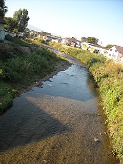
The Orăștie is a left tributary of the river Mureș in Romania. It discharges into the Mureș near the town Orăștie. Its length is 51 km (32 mi) and its basin size is 399 km2 (154 sq mi).
The Homorod is a right tributary of the river Mureș in Romania. It discharges into the Mureș near Geoagiu. Its length is 14 km (8.7 mi) and its basin size is 33 km2 (13 sq mi).
The Turdaș is a left tributary of the river Mureș in Romania. It discharges into the Mureș in the village Turdaș. Its length is 14 km (8.7 mi) and its basin size is 65 km2 (25 sq mi).
The Sibișel is a right tributary of the river Orăștie in Romania. It discharges into the Orăștie in the town Orăștie. Its length is 28 km (17 mi) and its basin size is 167 km2 (64 sq mi).
The Boz is a right tributary of the river Mureș in Romania. It discharges into the Mureș near the village Boz. Its length is 22 km (14 mi) and its basin size is 70 km2 (27 sq mi).
The Borzontul Mare is a left tributary of the river Mureș in Romania. It discharges into the Mureș near Joseni. The upper reach of the river is also known as Putna. Its length is 15 km (9.3 mi) and its basin size is 46 km2 (18 sq mi).
The Căian is a right tributary of the river Mureș in Romania. It discharges into the Mureș in Bejan. Its length is 25 km (16 mi) and its basin size is 170 km2 (66 sq mi).
The Ciugud is a right tributary of the river Mureș in Transylvania, Romania. It discharges into the Mureș in Inoc. Its length is 15 km (9.3 mi) and its basin size is 35 km2 (14 sq mi).
The Almaș is a right tributary of the river Mureș in Romania. It discharges into the Mureș near Zam. Its length is 18 km (11 mi) and its basin size is 86 km2 (33 sq mi).
The Gălăuțaș is a small river in the Gurghiu Mountains, Harghita County, central Romania. Its name is from the Hungarian "galóca", meaning "amanita" (mushroom). It is a left tributary of the river Mureș. It flows through the municipality Gălăuțaș, and joins the Mureș in the village Gălăuțaș. Its length is 11 km (6.8 mi) and its basin size is 16 km2 (6.2 sq mi).
The Șiștarovăț is a left tributary of the river Mureș in Romania. It discharges into the Mureș in Lipova. Its length is 11 km (6.8 mi) and its basin size is 59 km2 (23 sq mi).

European route E68 forms part of the United Nations International E-road network, linking Hungary with Romania. It starts in Szeged, Hungary, and ends in Braşov, Romania. Its total length is 529 km (329 mi) of which 52 km (32 mi) are in Hungary and 477 km (296 mi) in Romania.
