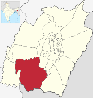
Churachandpur District, is one of the 16 districts of the Indian state of Manipur populated mainly by Kuki-Zo people. The name honours former Maharaja Sir Churachand Singh of Manipur. The district headquarters is located in the Churachandpur town, which is also locally known by the name Lamka.
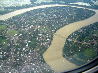
The Barak River or Barbakro flows 900 kilometres (560 mi) through the states of Manipur, Mizoram and Assam in India. It flows into Bangladesh where it bifurcates into the Surma river and the Kushiyara river which converge again to become the Meghna river before forming the Ganges Delta. Of its total length, 524 km (326 mi) is in India, 31 km (19 mi) in Bangladesh. The upper part of its navigable part is in India — 121 km (75 mi) between Lakhipur and Bhanga, declared as National Waterway 6, (NW-6) since the year 2016. It drains a basin of 52,000 km2 (20,000 sq mi), of which 41,723 km2 (16,109 sq mi) lies in India, 1.38% (rounded) of the country. The water and banks host or are visited by a wide variety of flora and fauna.
Jiribam is a town governed by a municipal council in the Jiribam district of the state of Manipur, India. It is one of the fastest-growing towns in Manipur.
Churachandpur, locally known as Lamka is the second largest town in the Indian state of Manipur and the district headquarters of the Churachandpur District. The name "Churachandpur" was transferred from the earlier headquarters of the district at Songpi to the present location, and honours Churachand Singh, former maharaja of the Manipur princely state. The local people reject the name as a colonial imposition and prefer using the native name "Lamka".
Tipaimukh Dam, officially "Tipaimukh Multipurpose Hydroelectric Dam Project", is a proposed dam on the Barak River at Sipuikawn (Tipaimukh) in Manipur, India. The purpose of the dam is flood control and hydroelectric power generation. The project was approved by the Government of India in 1999 and entrusted to the North Eastern Electric Power Corporation Limited, later switched to NHPC Limited. Due to environmental concerns as well as concerns in Bangladesh over downstream effects, the project remains under discussion and no construction has yet taken place.
The Zeliangrong people are one of the major indigenous Naga communities living in the tri-junction of Assam, Manipur and Nagaland in India. They are the descendants of Nguiba. The term "Zeliangrong" refers to the Zeme, Liangmai and Rongmei Kindred tribes combined. Earlier, the term also covered the Inpui tribe. The descendants of Hoi of Makuilongdi (Makhel) were divided and were made peripheral appendages to three political entities - Nagaland, Manipur and the Dima Hasao of Assam. The Zeliangrong may be classified as an ethno-cultural entity. The Zeliangrong belong to the larger Southern Mongoloid population and their language belongs to the Sino-Tibetan family of languages.

Pherzawl district is located in the southern part of the state of Manipur. It is bounded on the east by Churachandpur District; on the north by Tamenglong District, Noney District and Jiribam district; on the west by the Cachar District of Assam and on the South by Sinlung Hills, Mizoram. Pherzawl District has approximately 200 villages.

Jiribam District is a district at the western periphery state of Manipur, India. It borders the Cachar district of Assam on the west, and serves as the western gateway for Manipur. Formerly a subdivision of the Imphal East district, it was made an independent district in December 2016.

The Tuivai River is a river that originates in Myanmar and flows through the states of Manipur, Mizoram and Assam in India. It is the longest tributary of the Barak River, into which it flows at Tipaimukh near the village Sipuikawn.

Sipuikawn is a Hmar village in Pherzawl District, Manipur, Northeast India. It is located in south-western hilly region of Manipur bordering the Indian state of Mizoram. It is close to Tipaimukh, the southern tip of the Vangaitang range, where the Tuivai River joins the Barak River. The National Highway 2 passes through the village connecting the region to Mizoram and central Manipur. Sipuikawn is also known by its alternate name "Hmarkhawpui".
Thangjing Hill , is a mountain peak in the Indian state of Manipur. It is in the Churachandpur district, to the west of Moirang. The north–south-running mountain range on which it sits is also called Thangjing range or Thangjing Hills. The range forms part of the western border of the Imphal Valley.
Torbung is a census village split across the Bishnupur district and Churachandpur district in Manipur, India. The Bishnupur part of the village has a population of 2781, and the Churachandpur part a population of 1047 in the 2011 census. Torbung is on the bank of the Torbung river, which flows down from Thangjing hills to join the Khuga River. It is a village of historical as well as current political significance.
Henglep is a village in the Churachandpur district in the Manipur state of India, populated by about a thousand Kuki-Zo people. Henglep is also the headquarters of the Churachandpur North subdivision with a population of more than 30,000 people. Henglep was a key area of operations during the Kuki Rebellion of 1917–1919.

Senvawn is a Hmar village in Pherzawl district, Northeast India and is attributed to be the 'birthplace' of Christianity in Southern Manipur. The initial Christian converts among the Hmar and other sister tribes was made by a Welsh missionary Watkin Roberts in 1910. Senvon is also the 8th District Council Constituency (DCC) in the Churachandpur Autonomous District Council. According to the 2011 census, Senvawn holds 498 households
The Leimatak River is an upstream tributary of the Barak River in Manipur, India. It originates in the Churachandpur district near the Mamun Lhang peak, and flows north for 34 km (21 mi) before entering the Noney district. After flowing an equal amount of distance in the Noney district, it enters the Tamenglong district, where it drains into the Irang River, a major tributary of the Barak River.
Borobekra, also spelt Barabekra, is a village in the Jiribam district in Manipur, India, and the headquarters of an eponymous subdivision. It is about 30 km south of Jiribam, the headquarters of the district. The village is on the bank of the Barak River, near the confluence of a tributary that flows down from the Vangaitang range to the east. The Barak River flows north in this region, up to Jirimukh, where it turns northwest. The Barak River also forms the border with the Assam state of India.
Jarolpokpi, also called Zairawn, is a census village at the southern end of the Jiribam plain in the Jiribam district, Manipur, India. It occupies a narrow plain between the Vangaitang range in the east and Sejang hills in the west, covering 2.47 km2 (0.95 sq mi) area. Included in the census village are a Hmar village Zairawn, two Thadou Kuki villages Mongbung and Sejang Kuki, and a Meitei village Mongbung Meitei. The combined population of the Jarolpokpi census village is 1,237 people, of whom 64.2 percent are Scheduled Tribes.
Phaitol is a village in Manipur, India. It is at the foothills of the Vangaitang range, close to the National Highway 37. The village is part of Tamenglong district, Tousem Subdivision, but it is geographically located within the precincts of Jiribam district.
Durgapur is a census village in the Borobekra subdivision, Jiribam district, Manipur, India. It is about 35 km south of Jiribam, the headquarters of the district, close to the border with the Pherzawl district in the south. The village is on the bank of the Barak River, spanning a narrow valley between two forested hilly areas. The Barak River flows north in this region, up to Jirimukh, where it turns northwest. The Barak River also forms the border with the Assam state of India.


