Annyalla

Last updated

Annyalla
Eanaigh Gheala
Village
St. Michaels Church, Annyalla, Co. Monaghan (geograph 2452129).jpg
St Michaels Church
Ireland adm location map.svg
Red pog.svg
Annyalla
Location in Ireland
Coordinates: 54°09′40″N6°47′28″W / 54.161°N 6.791°W / 54.161; -6.791
CountryIreland
Province Ulster
County County Monaghan
Population
 (2022) [1]
205

Annyalla or Annayalla (Irish : Eanaigh Gheala, meaning 'bright marshes or pools') [2] is a small village and townland situated in the east of County Monaghan in Ireland between Castleblayney and Clontibret. As of the 2022 census, Annyalla had a population of 205. [1]

Contents

Geography

Monaghan GAA's training centre, at Cloghan, is approximately 1km from Annyalla Monaghan GAA Training Centre, Cloghan, Co. Monaghan - geograph.org.uk - 2452047.jpg
Monaghan GAA's training centre, at Cloghan, is approximately 1km from Annyalla

Annyalla townland is part of the civil parish of Clontibret. [2] Originally located on the main N2 road from Dublin to Derry, Annyalla was by-passed in 2007. [3] The Monaghan Gaelic Athletic Association training and development centre is located in nearby Cloghan townland.[ citation needed ]

History

Evidence of ancient settlement in the area includes a number of ring fort, lime kiln and megalithic monument sites in the townlands of Annayalla and Cloghan. [4]

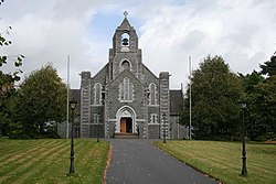
The main feature of the village is St Michael's church, built between 1922 and 1927. [5] It was designed by the architect William A Scott and completed under the supervision of R M Butler of University College Dublin. [6] [7] Annyalla's national school building, now disused, was opened in 1929. [8]

During the War of Independence, the area was the scene of several events involving the local 2nd Monaghan Brigade 5th Northern Division IRA Battalion. For example, on 25 May 1921, a member of the Black and Tans was wounded in an ambush in which the IRA unit seized a number of weapons. [9]

Annayalla was designated as a census town by the Central Statistics Office for the first time in the 2016 census, [10] at which time it had a population of 228 people. [11] By 2022, it had a population of 205. [1]

Related Research Articles

<span class="mw-page-title-main">Kinvara</span> Village in south County Galway, Ireland

Kinvara or Kinvarra is a sea port village in the southwest of County Galway, Ireland. It is located in the civil parish of Kinvarradoorus in the north of the barony of Kiltartan. Kinvarra is also an electoral division.

<span class="mw-page-title-main">Enniscrone</span> Seaside town in County Sligo, Ireland

Enniscrone – also spelt Inniscrone and officially named Inishcrone – is a small seaside town in County Sligo, Ireland. Its sandy beach, tourist campsite, and golf course all attract visitors. As of the 2022 census, the town had a population of 1,291 people.

<span class="mw-page-title-main">Carrickmacross</span> Town in County Monaghan, Ireland

Carrickmacross is a town in County Monaghan, Ireland. The town and environs had a population of 5,032 according to the 2016 census, making it the second-largest town in the county. Carrickmacross is a market town which developed around a castle built by the Earl of Essex in 1630. The town is 20 km west of Dundalk and 75 km north-north-west of Dublin city centre and 106 km south west of Belfast. Carrickmacross won the European Entente Florale Silver Medal Award in 1998. The local Gaelic football and hurling club is Carrickmacross Emmets. The local soccer team is Carrick Rovers.

The N2 road is a national primary road in Ireland, running from Dublin to the border with Northern Ireland at Moy Bridge near Aughnacloy, County Tyrone to connect Dublin with Derry and Letterkenny via the A5. A section of the route near Dublin forms the M2 motorway.

<span class="mw-page-title-main">Castleblayney</span> Town in County Monaghan, Ireland

Castleblayney is a town in County Monaghan, Ireland. The town had a population of 3,607 as of the 2016 census. Castleblayney is near the border with County Armagh in Northern Ireland, and lies on the N2 road from Dublin to Derry and Letterkenny.

<span class="mw-page-title-main">Camus, County Galway</span> Village in County Galway, Ireland

Camus or Camas is a small village in the Connemara Gaeltacht of County Galway, Ireland. It is between Casla and An Teach Dóite, and is divided into Camas Uachtair and Camas Íochtair, as well as several other townlands, such as Scríob, Gleann Trasna, Leitir Móir, and Doire Bhainbh.

<span class="mw-page-title-main">Clonegal</span> Village in County Carlow, Ireland

Clonegal, officially Clonegall, is a village in the southeast of County Carlow, Ireland. It is in a rural setting, close to the border between counties Wexford and Carlow, 5 km (3 mi) from Bunclody, County Wexford and 22 km (14 mi) from Carlow town. It is just over a mile north of where the River Slaney and the River Derry meet. Clonegal has a much smaller "twin" village across the River Derry in County Wexford, Watch House Village.

<span class="mw-page-title-main">Stradone, County Cavan</span> Village in County Cavan, Ireland

Stradone is a village located in County Cavan, Ireland. It is situated in the civil parish of Laragh six miles from Cavan, near the N3 road between Cavan and Virginia. Stradone is classified as a 'small village' in the Cavan County Council Development Plan 2014-2020.

<span class="mw-page-title-main">Clontibret</span> Village in County Monaghan, Ireland

Clontibret is a village and parish in County Monaghan, Ireland. The village population in the 2016 census was 172. Clontibret is also a parish in both Roman Catholic and Church of Ireland traditions. The territory of the parish also includes Annyalla and Doohamlet as well as smaller settlements such as Cremartin, Scotch Corner and Lisnagrieve.

<span class="mw-page-title-main">Scotshouse</span> Village in County Monaghan, Ireland

Scotshouse is a small agricultural village in the parish of Currin in County Monaghan, Ireland. It is roughly three miles east of where the counties of Cavan, Fermanagh and Monaghan meet. Scotshouse is about 7 kilometres (4 mi) from Clones, 18 km (11 mi) from Cavan town and 27 km (17 mi) away from Monaghan town.

<span class="mw-page-title-main">Quigley's Point</span> Village in County Donegal, Ireland

Quigley's Point is a village in County Donegal, Ireland. Located on the eastern shores of Inishowen and overlooking Lough Foyle, the village is sometimes known locally as "Carrowkeel" as it is in a townland of that name. To the south is the city of Derry and to the north lie the villages of Moville and Greencastle. A car ferry links Greencastle with Magilligan during the summer. The river Cabry, which flows through the area, is spanned by a late-18th century bridge at Quigley's Point.

<span class="mw-page-title-main">Watergrasshill</span> Village in County Cork, Ireland

Watergrasshill is a village in north east County Cork in Ireland. Watergrasshill is within the Cork North-Central Dáil constituency. Bypassed in 2003, the village is situated on the R639 road and accessible via junction 17 of the M8 motorway. It had a population of 1,840 at the 2022 census.

<span class="mw-page-title-main">Ballindrait</span> Village in County Donegal, Ireland

Ballindrait is a townland, village and census town in County Donegal, Ireland. Located near Lifford, the village and townland of Ballindrait is in the civil parish of Clonleigh and the barony of Raphoe North. The Burn Dale flows through the centre of Ballindrait.

<span class="mw-page-title-main">Doohamlet</span> Village in Ulster, Ireland

Doohamlet, is a village and townland on the Castleblayney–Ballybay road in County Monaghan, Ireland. It is part of a wider parish of Clontibret in the diocese of Clogher. Doohamlet village is located approximately three miles from the N2 Dublin-Derry route on the R183 road. The wider district comprises around thirty townlands.

Tassan is a townland in the parish of Clontibret in County Monaghan, Ireland.

<span class="mw-page-title-main">Curry, County Sligo</span> Village in Connacht, Ireland

Curry is a village and townland in County Sligo, Ireland. The townland has an area of approximately 3.9 square kilometres (1.5 sq mi), and had a population of 148 people as of the 2011 census.

<span class="mw-page-title-main">Castlejordan, County Meath</span> Village in County Meath, Ireland

Castlejordan is a village and townland in County Meath, Ireland. It is located in the south of the county, close to the border with County Offaly, to the south of Kinnegad. The townland of Castlejordan has an area of approximately 2.2 square kilometres (0.85 sq mi), and had a population of 85 people as of the 2011 census.

<span class="mw-page-title-main">Rathtoe</span> Village in County Carlow, Ireland

Rathtoe, also spelled Rathoe, is a village and townland in County Carlow, Ireland. The village is located in the civil parish of Gilbertstown, between Tullow and Ballon, County Carlow. The Burren River flows through the area. Rathtoe is a census town, and had a population of 304 as of the 2016 census.

<span class="mw-page-title-main">Oram, County Monaghan</span> Village in County Monaghan, Ireland

Oram is a village and townland in County Monaghan, Ireland. The village is on the R182 road, about 5 kilometres (3 mi) north-east of Castleblayney. The village population was 186 at the 2016 census.

References

  1. 1 2 3 "Annayalla (Ireland) Census Town". citypopulation.de. Retrieved 2 July 2024.
  2. 1 2 "Eanaigh Gheala / Annayalla". logainm.ie. Placenames Database of Ireland. Retrieved 22 August 2021.
  3. "N2 Castleblayney bypass opens". rte.ie. 5 November 2007. Retrieved 2 July 2024. The new €115m N2 Dublin/Derry bypass [..] will take traffic away from [..] Annyalla and Clontibret villages
  4. Archaeological Inventory of County Monaghan. Dublin: Government Stationery Office. 1986. ISBN   9780707600291.
  5. Carvlle, Gary (2002). In Faith and Hope: The Story of St Michael's Church Annyalla and the parish of Clontibret. Castleblaney: Castle Printing. pp. 32–64. OCLC   1418932072.
  6. "Saint Michael's Church, Monaghan". buildingsofireland.ie. National Inventory of Architectural Heritage. Retrieved 22 August 2021.
  7. "Co. Monaghan, Annyalla, Church of St Michael (RC)". Dictionary of Irish Architects. Irish Architectural Archive. Retrieved 22 August 2021.
  8. "Annyalla National School, Annyalla, Monaghan". buildingsofireland.ie. National Inventory of Architectural Heritage. Retrieved 2 July 2024.
  9. "Military Archives Ireland - A55 - 2nd Monaghan Brigade 5th Northern Division" (PDF), militaryarchives.ie, p. 5, Ambush of Black and Tan Patrol and seizure of arms at Annayalla, Castleblayney, Co. Monaghan. (one enemy wounded) May 1921.
  10. "Census of Population 2016 - Profile 2 Population Distribution and Movement". cso.ie. Central Statistics Office. Retrieved 26 June 2021. 26 new census towns were created for the 2016 Census [..including..] Annayalla
  11. "Sapmap Area - Settlements - Annayalla". Census 2016. Central Statistics Office. April 2016. Archived from the original on 22 August 2021.