The Antelope Creek Phase was an American Indian culture in the Texas Panhandle and adjacent Oklahoma dating from AD 1200 to 1450.[1] The two most important areas where the Antelope Creek people lived were in the Canadian River valley centered on present-day Lake Meredith near the city of Borger, Texas and the Buried City complex in Wolf Creek valley near the town of Perryton, Texas. Settlements are also found in Oklahoma near the town of Guymon and along the Beaver River.
The Texas Panhandle is a region of the U.S. state of Texas consisting of the northernmost 26 counties in the state. The panhandle is a rectangular area bordered by New Mexico to the west and Oklahoma to the north and east. The Handbook of Texas defines the southern border of Swisher County as the southern boundary of the Texas Panhandle region.
Oklahoma is a state in the South Central region of the United States, bordered by Kansas on the north, Missouri on the northeast, Arkansas on the east, Texas on the south, New Mexico on the west, and Colorado on the northwest. It is the 20th-most extensive and the 28th-most populous of the fifty United States. The state's name is derived from the Choctaw words okla and humma, meaning "red people". It is also known informally by its nickname, "The Sooner State", in reference to the non-Native settlers who staked their claims on land before the official opening date of lands in the western Oklahoma Territory or before the Indian Appropriations Act of 1889, which dramatically increased European-American settlement in the eastern Indian Territory. Oklahoma Territory and Indian Territory were merged into the State of Oklahoma when it became the 46th state to enter the union on November 16, 1907. Its residents are known as Oklahomans, and its capital and largest city is Oklahoma City.
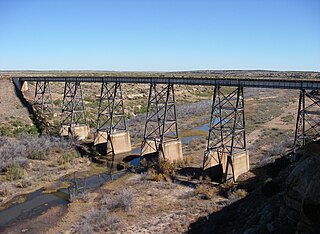
The Canadian River is the longest tributary of the Arkansas River in the United States. It is about 906 miles (1,458 km) long, starting in Colorado and traveling through New Mexico, the Texas Panhandle, and Oklahoma. The drainage area is about 47,700 square miles (124,000 km2).
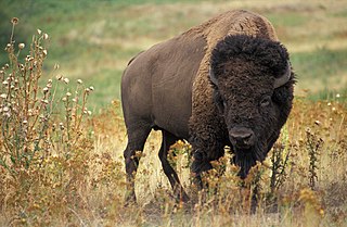
The Antelope Creek People were bison hunters, maize farmers, and foragers. They are best known for building large, stone, multifamily dwellings, unique on the Great Plains. Their culture combined charactieristics of Southwestern Ancestral Pueblo peoples and Great Plains tribes.
The Great Plains is the broad expanse of flat land, much of it covered in prairie, steppe, and grassland, that lies west of the Mississippi River tallgrass prairie in the United States and east of the Rocky Mountains in the U.S. and Canada. It embraces:
The Antelope Creek Phase is also called the Antelope Creek Focus, the Panhandle Phase, the Optima Focus, and the Upper Canark Variant.[2]
Panhandle culture is a prehistoric culture of the southern High Plains during the Middle Ceramic Period from AD 1200 to 1400. Panhandle sites are primarily in the panhandle and west central Oklahoma and the northern half of the Texas Panhandle.
Origin
The Antelope Creek people is were the most southwestern of the cultures making up the Plains Village Tradition which stretched from North Dakota to Texas and extended westward in river valleys from the Eastern Woodlands into the Great Plains. The Plains Villagers adopted the cultivation of corn (maize) and by AD 900 they were living in semi-permanent villages along the watercourses traversing the plains, including, for example, the Washita and Canadian Rivers in Oklahoma.[3] By AD 1250, these river valleys were heavily populated with villages of up to 20 houses situated about every two miles.[4]
The Washita River is a river in the states of Texas and Oklahoma in the United States. The river is 295 miles (475 km) long and terminates at its confluence with the Red River, which is now part of Lake Texoma on the Texas–Oklahoma border.
The Canadian River and the Alibates Flint Quarries National Monument. The Antelope Creek People lived mostly on terraces overlooking the river or in side canyons with springs.
Most archaeologists believe that the Antelope Creek Phase was a western expansion of farming communities from Oklahoma into the Texas panhandle or an extension southward of similar farming communities from further north.[5] Although farming was difficult in the dry climate of the Texas panhandle, other food resources such as bison were abundant. Bison or American buffalo are believed to have been uncommon on the southern Great Plains before AD 1000. As the bison population expanded thereafter due to climatic conditions, they became the principal source of protein for people on the southern Plains and their abundance stimulated a growth in population and complexity of the hunting-gathering societies that had inhabited the region for thousands of years. Archaeological sites confirm increased exploitation of bison after AD 1200.[6]
Bison are large, even-toed ungulates in the genus Bison within the subfamily Bovinae.
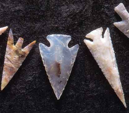
A major asset of the Canadian River Valley was the large deposits of colorful Alibates flint that could be chipped into tools and weapons and traded to other cultures. The present-day Alibates Flint Quarries National Monument preserves more than 700 quarries where the Indians dug out the flint. Most of the quarries are holes six feet or more in diameter and four to eight feet deep. The presence of Alibates Flint was undoubtedly an economic incentive to settle nearby to control trade in the stone.[7] Alibates flint tools have been found up to one thousand miles away.
Alibates Flint Quarries National Monument is a U.S. National Monument in the State of Texas. For thousands of years, people came to the red bluffs above the Canadian River for flint, vital to their existence. Demand for the high quality, rainbow-hued flint is reflected in the distribution of Alibates Flint through the Great Plains and beyond. Indians of the Ice Age Clovis Culture used Alibates flint for spear points to hunt the Imperial Mammoth before the Great Lakes were formed. The flint usually lies just below the surface at ridge level in a layer up to six feet thick. The quarry pits were not very large, between 5 and 25 feet wide and 4 to 7 feet deep. Many of these quarries were exploited by the Antelope Creek people, of the Panhandle culture, between 1200 and 1450. The stone-slabbed, multi-room houses built by the Antelope Creek people have long been of interest to the public and studied by archaeologists. Today this area is protected by the U.S. National Park Service and can only be viewed by ranger-led guided tours, which must be reserved in advance.
Most archaeologists believe that the Antelope Creek people spoke a Caddoan language and probably ancestors of the historic Wichita and affiliated tribes, possibly, the Pawnee. That opinion is based primarily on the fact that in historic times the farming communities on the Southern Plains were primarily Caddoans. An alternative thesis is that the Antelope Creek people were Pueblo Indians who moved or were pushed onto the Great Plains from their homes near the valley of the Rio Grande in New Mexico. It is also possible that the Antelope Creek people were neither Caddoan nor Pueblo, but an entirely different people. Nor is it certain that all the people of the Antelope Creek culture spoke the same language or belonged to the same ethnic group.[8]
Pioneering archaeologist Alex D. Kreiger summed up the evidence: “To attempt to classify Antelope Creek Focus as either a Plains or Pueblo culture is infeasible, for it was clearly a combination of both. … One can hardly escape the impression that the peoples of this focus were Plains agriculturalists who pushed southward from one valley to another as far as eastern New Mexico. Here contact was established with Puebloans who were expanding their territories at the same time.”[9]
Houses and settlements
The unique and enigmatic characteristic of Antelope Creek was the construction of large stone-slab and plaster houses and one-story apartment blocks. Elsewhere on the Great Plains pre-historic Indian farmers lived in homes constructed from wood, earth, and straw.[10]
Hundreds of Antelope Creek settlements have been discovered. Archaeologist Christopher Lintz identified eleven different variations of buildings in villages, hamlets and isolated farmsteads. The most notable buildings were rectangular, single-storied, multi-room structures with up to 30 rooms. The rooms ranged in size from small up to 60 square meters square (roughly 30 feet by 20 feet). The multi-room dwellings appear to have been constructed between 1200 and 1350. Thereafter, individual dwellings were preferred, often about 6 meters by 6 meters (20×20 feet) in size and using the same stone-slab construction methods.[11]
Houses typically consisted of an east-facing vestibule leading to a single square room recessed about one foot (30cm) into the ground. The house was divided into thirds. Along the north and south walls of the house were raised benches or platforms; the hearth was located in the center third of the house at a lower level. A platform or table on the west wall of the house may have been an altar. Storage bins were also located against the west wall and pits for storage were dug beneath the benches. Four upright wooden posts near the center of the dwelling held up the roof which was probably sloped and made of intertwined straw and saplings.[12] There was, however, a large variety in the structures built by the Antelope Creek people. The time and effort involved in stone-slab and plaster construction implies confidence by the people in the permanence of their settlements.
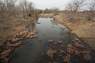
Although some Antelope Creek people lived in the multi-family dwellings, more often they clustered in hamlets of individual homes with a population of not more than eight families. Between hamlets were isolated farmsteads of one or two houses.[13] Most dwellings were located on terraces above the Canadian River or near a spring-fed stream or tributary. The population in some areas was dense. The five-mile long Buried City complex on Wolf Creek has more than 100 dwellings capable of housing 15 to 20 people each. The dwellings are spaced about 100 yards from each other, thus resembling the settlement pattern of an American suburb with houses on large lots. If all these dwellings were occupied at the same time, the population may have been 2,000.[14] Along 50 miles of the Canadian River were more than 300 multi-family dwellings with a population that may have exceeded 10,000. The total population of the Texas Panhandle during the Antelope Creek Phase may have amounted to as many as 30,000. Water can be scarce on the Great Plains, but beneath the surface is the Oglalla aquifer. The water of the Canadian River is salty, so the Antelope Creek people often lived where streams had cut 100 to 200 feet deep into the caprock and springs and small spring-fed watercourses were abundant and reliable. Timber for building and fuel was found in these valleys and canyons.[15]
Subsistence
The evidence points to a three-faceted strategy for subsistence among the Antelope Creek people: (1) hunting bison and other animals; (2) cultivation of maize, beans, squash, and sunflowers; and (3) foraging for edible nuts, fruits, and seeds. The relative importance of each of these activities is unclear.
Antelope Creek men probably wandered long distances from their village to hunt bison. Although bison were their most important prey, the bones of deer, antelope, and smaller game have also been found in the ruins, plus a few mussels and fish. The scapula of bison also served as an agricultural tool for digging and hoeing.
Arrowheads made from Alibates flint
The Antelope Creek people grew corn, beans, squash and probably sunflowers. The Texas Panhandle is a marginal area for unirrigated agriculture, prone to drought and with the bulk of the 16- to 20-inch annual rainfall coming in a few thunderstorms that cause flooding. Thus, the Antelope Creek people probably practiced water harvesting or “Ak-Chin” dryland farming techniques. Crops were planted in arroyos or other depressions which caught runoff from thunderstorms and preserved enough moisture to permit crops to grow and mature. Given the unpredictability of rainfall, a family probably planted small fields – as did other Southwestern peoples—in several different micro-environments with the objective of maximizing the possibility that some of their fields would be productive. In their farming, the Antelope Creek people used bone-tipped digging sticks and bison scapulas as shovels and hoes.[16]
Foraging of wild plants for food was probably important for the Antelope Creek People, particularly because agriculture in the drought-prone panhandle was always hazardous and the abundance of bison varied from season to season and year to year. Among the wild foods eaten were acorns, hackberries, mesquite, buckwheat, plums, persimmons, prickly pear, mallow, cattail, purslane, goosefoot, knotweed, domesticated marshelder, and bulrush.[17]
Food was often cooked in pottery vessels which were made locally and also imported—increasingly as time went on—from the Rio Grande Pueblos. Trade increased dramatically after 1350, indicating the growth of a more outward looking and possibly more mobile Antelope Creek culture.[18]
The end of Antelope Creek
The Antelope Creek settlements were abandoned between 1450 and 1500. When Spanish conquistador Francisco Vásquez de Coronado passed through the Texas Panhandle in 1541 he met only nomadic and semi-nomadic buffalo-hunting Indians he called Querechos (Apache) and Teyas (the later possibly Caddoan).[19]
Several reasons have been advanced for the disappearance of the Antelope Creek people in this region. The first theory is that they exhausted their resources over time and were forced to resettle elsewhere. The second theory is that drought made agriculture increasingly infeasible in the Panhandle and the Antelope Creek people moved to better agricultural lands. The third is that they were forced out of their homes by other Indians, most likely the Apache who were new arrivals to the Southern Plains. Whatever the reason, most archaeologists speculate that the Antelope Creek people migrated eastward to Kansas and Oklahoma and become the Wichita and affiliated tribe, whom Coronado met in Quivira in 1541. The Pawnee of Nebraska also have an oral history that they once lived in stone houses in the Southwest.[20]
Related Research Articles
The Oklahoma Panhandle is the extreme northwestern region of the U.S. state of Oklahoma, consisting of Cimarron County, Texas County and Beaver County, from west to east. As with other salients in the United States, its name comes from the similarity of its shape to the handle of a pan.
The Wichita people or Kitikiti'sh are a confederation of Southern Plains Native American tribes. Historically they spoke the Wichita language and Kichai language, both Caddoan languages. They are indigenous to Oklahoma, Texas, and Kansas.
Plains Indians, Interior Plains Indians or Indigenous people of the Great Plains and Canadian Prairies are the Native American tribes and First Nation band governments who have traditionally lived on the greater Interior Plains in North America. Their historic nomadic culture and development of equestrian culture and resistance to domination by the government and military forces of Canada and the United States have made the Plains Indian culture groups an archetype in literature and art for American Indians everywhere.
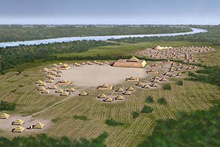
Spiro Mounds is a major Northern Caddoan Mississippian archaeological site located in present-day Eastern Oklahoma. The 80-acre site lies near the Arkansas River in Fort Coffee, seven miles north of the town of Spiro.
The history of Oklahoma refers to the history of the state of Oklahoma and the land that the state now occupies. Areas of Oklahoma east of its panhandle were acquired in the Louisiana Purchase of 1803, while the Panhandle was not acquired until the U.S. land acquisitions following the Mexican–American War.
Antonio de Espejo was a Spanish explorer who led an expedition into New Mexico and Arizona in 1582–83. The expedition created interest in establishing a Spanish colony among the Pueblo Indians of the Rio Grande valley.
Prehistory of Colorado provides an overview of the activities that occurred prior to Colorado's recorded history. Colorado experienced cataclysmic geological events over billions of years, which shaped the land and resulted in diverse ecosystems. The ecosystems included several ice ages, tropical oceans, and a massive volcanic eruption. Then, ancient layers of earth rose to become the Rocky Mountains.
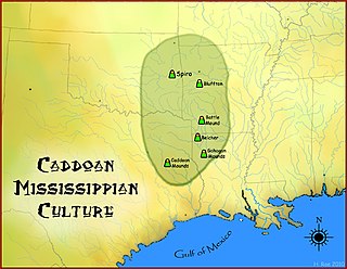
The Caddoan Mississippian culture was a prehistoric Native American culture considered by archaeologists as a variant of the Mississippian culture. The Caddoan Mississippians covered a large territory, including what is now Eastern Oklahoma, Western Arkansas, Northeast Texas, and Northwest Louisiana. Archaeological evidence that the cultural continuity is unbroken from prehistory to the present; that the direct ancestors of the modern Caddo Nation of Oklahoma included the speakers of the Caddo and related Caddo language in prehistoric times and at first European contact, is unquestioned today.
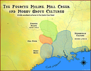
The Fourche Maline culture was a Woodland Period Native American culture that existed from 300 BCE to 800 CE, in what are now defined as southeastern Oklahoma, southwestern Arkansas, northwestern Louisiana, and northeastern Texas. They are considered to be one of the main ancestral groups of the Caddoan Mississippian culture, along with the contemporaneous Mill Creek culture of eastern Texas. This culture was named for the Fourche Maline Creek, a tributary of the Poteau River. Their modern descendants are the Caddo Nation of Oklahoma.
The Querechos were a Native American people.
Teyas were a Native American people living near Lubbock, Texas who first made contact with Europeans in 1541 when Francisco Vásquez de Coronado traveled to them.
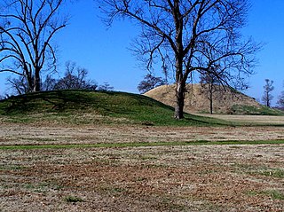
Plum Bayou culture is a Pre-Columbian Native American culture that lived in what is now east-central Arkansas from 650—1050 CE, a time known as the Late Woodland Period. Archaeologists defined the culture based on the Toltec Mounds site and named it for a local waterway.
The Trinchera Cave Archeological District (5LA9555) is an archaeological site in Las Animas County, Colorado with artifacts primarily dating from 1000 BC to AD 1749, although there were some Archaic period artifacts found. The site was added to the National Register of Historic Places in 2001 and is located on State Trust Lands.
The following outline is provided as an overview of and topical guide to the prehistoric people of Colorado, which covers the period of when Native Americans lived in Colorado prior to contact with the Dominguez-Escalante Expedition in 1776. People's lifestyles included nomadic hunter-gatherering, semi-permanent village dwelling, and residing in pueblos.
The Apishapa culture, or Apishapa Phase, a prehistoric culture from 1000-1400, was named based upon an archaeological site in the Lower Apishapa canyon in Colorado. The Apishapa River, a tributary of the Arkansas River, formed the Apishapa canyon. In 1976, there were 68 Apishapa sites on the Chaquaqua Plateau in southeastern Colorado.
Agriculture on the prehistoric Great Plains describes the agriculture of the Indian peoples of the Great Plains of the United States and southern Canada in the Pre-Columbian era and before extensive contact with European explorers, which in most areas occurred by 1750. The principal crops grown by Indian farmers were maize (corn), beans, and squash, including pumpkins. Sunflowers, goosefoot, tobacco, gourds, and plums, were also grown.
The Southern Plains villagers were semi-sedentary Indians who lived on the Great Plains in western Oklahoma, Texas, Kansas, and southeastern Colorado from about AD 800 until AD 1500.
The Plains Village period or the Plains Village tradition is an archaeological period on the Great Plains from North Dakota down to Texas, spanning approximately 900/950 to 1780/1850 CE.
↑ Gibbon, Guy E. Ed. Archaeology of Pre-Historic Native America: An Encyclopedia. NY:Routledge, 1998, p. 20
↑ Drass, Richard R. “Redefining Plains Village Complexes in Oklahoma: the Paoli Phase and the Redbed Plains Variant.” Plains Anthropologist, Vol 44, No. 168, 1999, pp. 121–140
↑ ”Texas Beyond History.” http://www.texasbeyondhistory.net/villagers/buriedcity/who.html, accessed Nov 11, 2010; Drass, Richard R. and Flynn, Peggy. “Temporal and Geographic Variations in Subsistence Practices for Plains Villagers in the Southern Plains.” Plains Anthropologist, Vol. 135, No. 128, 1990, pp. 187–188
↑ Brooks, Robert L. “From Stone Slab Architecture to Abandonment” in Perttula, Timothy K. The Prehistory of Texas. College Station: Texas A&M U Press, 2004, pp. 334–335
↑ Kreiger, Alex D. Cultural Complexes and Chronology of Northern Texas. Austin: University of Texas Press, 1946, p. 73
↑ The basic reference is Lintz, Christopher. Architecture and Community Variability within the Antelope Creek Phase of the Texas Panhandle. Studies in Oklahoma’ Past No. 14: Norman: OK Archaeological Survey, 1986. See also Brooks, 336
↑ Winship, George Parker (Ed. and Translator) The Journey of Coronado, 1540–1542, from the City of Mexico to the Grand Canyon of the Colorado and the Buffalo Plains of Texas, Kansas, and Nebraska, As Told by Himself and his Followers. New York: A.S. Barnes & Co, 1904, 142–215
This page is based on this Wikipedia article Text is available under the CC BY-SA 4.0 license; additional terms may apply. Images, videos and audio are available under their respective licenses.