A border checkpoint is a location on an international border where travelers or goods are inspected and allowed passage through. Authorization often is required to enter a country through its borders. Access-controlled borders often have a limited number of checkpoints where they can be crossed without legal sanctions. Arrangements or treaties may be formed to allow or mandate less restrained crossings. Land border checkpoints can be contrasted with the customs and immigration facilities at seaports, international airports, and other ports of entry.
Form I-94, the Arrival-Departure Record Card, is a form used by U.S. Customs and Border Protection (CBP) intended to keep track of the arrival and departure to/from the United States of people who are not United States citizens or lawful permanent residents. While the form is usually issued by CBP at ports of entry or deferred inspection sites, USCIS can issue an equivalent as part of the Form I-797A approval notice for a Form I-129 petition for an alien worker or a Form I-539 application for extension of stay or change of status.

The Western Hemisphere Travel Initiative (WHTI) is the implementation of a requirement to show a passport or other acceptable document to enter the United States, for nationals of certain North American jurisdictions who were previously exempt from it when traveling within the Americas. The requirement comes from the Intelligence Reform and Terrorism Prevention Act, enacted in 2004 in response to the terrorist attacks of September 11, 2001, and implemented in phases between 2007 and 2009. According to the United States Department of Homeland Security, the purpose is to strengthen border security and facilitate entry into the United States for both U.S. citizens and foreign visitors.
Noyes is an unincorporated community in St. Vincent Township, Kittson County, Minnesota, United States. Located in the extreme northwestern corner of the state on the Canada–United States border, Noyes is the northern terminus of U.S. Highway 75 and site of a former road border crossing. U.S. Customs and Border Protection operates a customs inspection station for the Canadian Pacific and BNSF Railway lines that enter from Canada at Noyes. The community of Emerson, Manitoba, lies adjacent to Noyes on the Canadian side of the border.
Federal Highway 2 is a free part of the Mexican federal highway corridors that runs along the U.S. border. The highway is in two separate improved segments, starting in the west at Tijuana, Baja California, on the Pacific coast and ending in the east in Matamoros, Tamaulipas, on the Gulf of Mexico. Fed. 2 passes through the border states of Baja California, Sonora, Chihuahua, Coahuila, Nuevo Leon and Tamaulipas. It has a total length of 1,987 kilometres (1,235 mi); 1,343 kilometres (835 mi) in the west and 644 kilometres (400 mi) in the east.

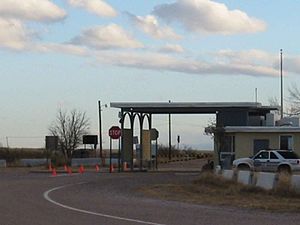
Antelope Wells is a small unincorporated community in Hidalgo County, New Mexico, United States. The community is located along the Mexico-United States border, in the New Mexico Bootheel region, located across the border from the small settlement of El Berrendo, Chihuahua, Mexico.
El Berrendo is a town in the Mexican state of Chihuahua, located in Janos Municipality, directly across the U.S. border from Antelope Wells, New Mexico. According to the Population Census and Housing of 2010 from INEGI, there was only 1 inhabitant.

The Bridge of the Americas (BOTA) is a group of international bridges which cross the Rio Grande and Texas State Highway Loop 375, connecting the Mexico–United States border cities of Ciudad Juárez, Chihuahua, and El Paso, Texas, via the MX 45 from the south and the I-110 from the north, crossing the El Paso BOTA Port of Entry. The bridge is known colloquially as "Puente Libre" in Ciudad Juárez, officially as "Puente Internacional Córdova-Las Américas" or "Puente Internacional Córdova de las Américas", and also as "Puente Río Bravo", "Cordova Bridge", and "Free Bridge".

The Paso del Norte International Bridge is an international bridge which crosses the Rio Grande connecting the United States-Mexico border cities of El Paso, Texas, and Ciudad Juárez, Chihuahua. The bridge is also known as "Paso del Norte Bridge", "Santa Fe Street Bridge", "Puente Benito Juárez", "Puente Paso del Norte" and "Puente Juárez-Santa Fe". The Paso del Norte International Bridge is a four-lane bridge for northbound non-commercial traffic only. The bridge was constructed in 1967. The American side of the bridge is owned and operated by the City of El Paso.

The New Mexico Bootheel is a salient (protrusion) which comprises the southwestern corner of New Mexico. As part of the Gadsden Purchase it is bounded on the east by the Mexican state of Chihuahua along a line at 31°47′0″N108°12′30″W extending south to latitude 31°20′0″N at 31°20′0″N108°12′30″W. The southern border is shared between the Mexican states of Chihuahua and Sonora along latitude 31°20′0″N, while the western border with Arizona is along meridian 109°03′0″W at 31°20′0″N109°03′0″W, bounding an area of 50 by 30 miles and comprising 1,500 square miles (3,900 km2).

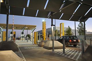
The San Ysidro Port of Entry is the largest land border crossing between San Diego and Tijuana, and the fourth-busiest land border crossing in the world with 70,000 northbound vehicles and 20,000 northbound pedestrians crossing each day, in addition to southbound traffic. It connects Mexican Federal Highway 1 on the Mexican side with Interstate 5 on the American side. The San Ysidro Port of Entry is one of three ports of entry in the San Diego–Tijuana metropolitan region.
The Otay Mesa Port of Entry is one of three ports of entry (POE) in the San Diego–Tijuana metropolitan region, in the U.S. state of California, connecting Otay Mesa in San Diego with the Otay Centenario borough of Tijuana. The facility was opened in 1983, and was constructed primarily to divert growing commercial truck traffic from the busy San Ysidro Port of Entry, located 5.2 miles (8.4 km) west. Since then, significant passenger vehicle and pedestrian traffic has grown as development in the area around the crossing has grown. Commercial importations through Otay Mesa accounts for billions of dollars' worth of freight.

The Andrade Port of Entry is the easternmost and lowest volume border crossing of the United States-Mexico border in California, USA. It is located 2 miles south of Interstate 8, and about 2000 feet west of the Colorado River, in Imperial County opposite the Los Algodones border crossing in Baja California, Mexico. It is connected to Interstate 8 by California State Route 186. It is a minor port in comparison to the larger Calexico West and Calexico East Ports of Entry. In spite of its remote desert location, it supports significant tourist traffic volume. The Andrade-Los Algodones border crossing is also Mexico's northernmost port of entry. The port ranked 11th for pedestrian crossings in 2010, with more than one million people processed by U.S. Customs and Border Protection.

The Lukeville, Arizona Port of Entry was established by Executive Order in 1949. It has primarily been a port of entry for passenger vehicles and pedestrians.

The Columbus New Mexico Port of Entry is an international border crossing between Columbus, New Mexico, United States, and Palomas, Chihuahua, Mexico. Located at the southern terminus of New Mexico State Road 11, it is one of three border crossings into New Mexico, along with the Antelope Wells Port of Entry and the Santa Teresa Port of Entry.
The Marcelino Serna Port of Entry is a crossing of the United States–Mexico border. It opened on November 17, 2014, replacing the nearby Fabens Port of Entry. The crossing is built around the Tornillo–Guadalupe International Bridge about 1,800 feet (550 m) west of the previous two-lane Fabens–Caseta International Bridge and can accommodate vehicular, pedestrian, and commercial traffic. The U.S. Customs and Border Protection (CBP) facility at the crossing served as the site for the Tornillo tent city, which housed as many as 2,800 detained migrant youths from June 2018 to January 2019. As of July 2019, a 2,500-bed holding facility for adult migrants is under construction at the site.
New Mexico State Road 81 is a 45.8-mile-long (73.7 km) state road in southwestern New Mexico. The route runs from the Mexico–U.S. border in Antelope Wells north to NM 9 in Hachita, passing through desert and semi-arid farmland. NM 81 is maintained by the New Mexico Department of Transportation (NMDOT).

The Nighthawk–Chopaka Border Crossing connects the town of Loomis, Washington and Cawston, British Columbia on the Canada–United States border. Similkameen Road on the American side joins Nighthawk Road on the Canadian side.

The Metaline Falls–Nelway Border Crossing connects the town of Metaline Falls, Washington with Nelway and Nelson, British Columbia at the Canada–US border. Access is via Washington State Route 31 on the American side and British Columbia Highway 6 on the Canadian side. This is the easternmost crossing in Washington.
The Tornillo–Guadalupe International Bridge is an international bridge which crosses the Rio Grande connecting the United States–Mexico border towns of Tornillo, Texas and Guadalupe, Chihuahua. The bridge was built in 2016 to replace and upgrade the Fabens–Caseta International Bridge a few hundred yards to the west. The new bridge bypasses the village of Caseta.