Anubanini rock relief

Last updated
Anubanini rock relief
Anubanini Rock Relief 1.jpg
Original relief.
Anubanini relief components.jpg
Components of the relief (extracted): king Anubanini trampling a foe, goddess Ishtar, two groups of prisoners, and an inscription in Akkadian language.
West Asia non political with water system.jpg
Red pog.svg
Anubanini relief
Red pog.svg
Behistun relief
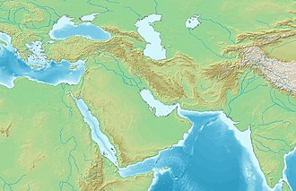
Comparative locations of Behistun and the Anubanini rock reliefs.

The Anubanini petroglyph, also called Sar-e Pol-e Zohab II [1] or Sarpol-i Zohab relief, [2] is a rock relief from the Akkadian Empire period (circa 2300 BC) or the Isin-Larsa period (early second millennium BC) and is located in Kermanshah Province, Iran. [2] [1] The rock relief is believed to belong to the Lullubi culture and is located 120 kilometers away from the north of Kermanshah, close to Sarpol-e Zahab. Lullubi reliefs are the earliest rock reliefs of Iran, later ones being the Elamite reliefs of Eshkaft-e Salman and Kul-e Farah.

Contents

Description

In this rock relief, Anubanini, the king of the Lullubi, puts his foot on the chest of a captive. There are eight other captives, two of them kneeling behind the Lullubian equivalent of the Akkadian goddess Ishtar (recognisable by the four pairs of horns on her headdress and the weapons over her shoulders) and six of them standing in a lower row at the bottom of the rock relief. [1] He is bare-chested, only wearing a short skirt. [1]

The general style of the Anubanini relief emulates the style of Mesopotamian royal art of the period, as well as its language, in using the Akkadian language and script for this inscription. [3]

Inscription

There's also an inscription in the Akkadian language and Akkadian script. In the inscription, he declares himself as the mighty king of Lullubium, who had set up his image as well as that of Ishtar on mount Batir, and calls on various deities to preserve his monument. [4] The inscription begins with the formula:

Transcription Anubanini rock relief inscription.jpg
Transcription

Anubanini, the mighty king, king of Lullubum, erected a image of himself and an image of Goddess Ninni on the mount of Batir... (follows a lengthy curse formula invoking deities Anu, Antum, Enlil, Ninlil, Adad, Ishtar, Sin and Shamash towards anyone who would damage the monument)

Akkadian language inscription of the Anubanini relief. [1] [4] [5]

The date of the rock relief is believed to be circa 2300 BC. It was damaged about 30% during the Iran-Iraq war. [6] Older photographs show in particular a nearly undamaged figure of the king. [7]

Photograph by Ernst Herzfeld Anubanini rock relief Ernst Herzfeld 1913.jpg
Photograph by Ernst Herzfeld

Behistun reliefs

This rock relief is very similar to the much later Achaemenid Behistun reliefs (fifth century BC), not located very far, to such an extent that it was said that the Behistun Inscription was influenced by it. The attitude of the ruler, the trampling of an enemy, the presence of a divinity, the lines of prisoners are all very similar. [2] [8]

Details of the relief

Early depictions

The French architect Pascal Coste painted the rock relief as early as 1840.

Other reliefs in the area

The same area of Sar-e Pol-e Zahab, has three more, less well-preserved reliefs.

Lullubian reliefs

Another relief named Sar-e Pol-e Zohab I is about 200 meters away, in a style similar to the Anubanini relief, but this time with a beardless ruler. [1] The attribution to a specific ruler remains uncertain. [1] There are also other Lullubian relief in the same area of Sar-e Pol-e Zahab, showing a beardless warrior trampling a foe, facing a goddess. [1] [13]

Parthian relief

Another relief is located below the Anubanini relief, lower on the cliff. This relief was created during the Parthian Empire in the name of Gotarzes, possibly Gotarzes I, but more probably the Parthian king Gotarzes II, who ruled from 39 to 51 CE and is known to have made other reliefs, such as the equestrian relief at Behistun. [17] [18]

Dukkan-e Daud Late Achemenid tomb

At Dukkan-e Daud, not far from Sar-e Pol-e Zohab, there is a late Achaemenid tomb (circa 400–300 BCE) with the relief of a Zoroastrian priest.

See also

Related Research Articles

<span class="mw-page-title-main">Behistun Inscription</span> Ancient multilingual stone inscription in Iran

The Behistun Inscription is a multilingual Achaemenid royal inscription and large rock relief on a cliff at Mount Behistun in the Kermanshah Province of Iran, near the city of Kermanshah in western Iran, established by Darius the Great. It was important to the decipherment of cuneiform, as it is the longest known trilingual cuneiform inscription, written in Old Persian, Elamite, and Babylonian.

<span class="mw-page-title-main">Hyrcania</span> Historical region in the south-east of the Caspian sea

Hyrcania is a historical region composed of the land south-east of the Caspian Sea in modern-day Iran and Turkmenistan, bound in the south by the Alborz mountain range and the Kopet Dag in the east.

<span class="mw-page-title-main">Kermanshah province</span> Province of Iran

Kermanshah Province is one of the 31 provinces of Iran and one of the provinces which border Iraq. The province was known from 1969 to 1986 as Kermanshahan, and from 1986 to 1995 as Bakhtaran. The capital of the province is the city of Kermanshah. According to a 2014 segmentation by the Ministry of Interior, it is the center of Region 4, with the region's central secretariat located in Kermanshah. A majority of people in Kermanshah Province are Shia, and there are Sunni and Yarsani minority groups.

<span class="mw-page-title-main">Gotarzes II</span> 1st century AD king of the Parthian Empire

Gotarzes II was king of the Parthian Empire from 40 to 51. He was an adopted son of Artabanus II. When his father died in 40, his brother Vardanes I was to succeed to the throne. However, the throne was seized by Gotarzes II. Gotarzes II eventually was able to gain control of most of Parthia forcing Vardanes to flee to Bactria. With the death of Vardanes in c. 46, Gotarzes II ruled the Parthian Empire until his death. Gotarzes II was succeeded by his uncle Vonones II.

<span class="mw-page-title-main">Gotarzes I</span> Great King, Arsaces

Gotarzes I was king of the Parthian Empire from 91 BC to 87 or 80 BC. He was the son and successor of Mithridates II, and was succeeded by his son Orodes I.

<span class="mw-page-title-main">Orodes I of Parthia</span> Great King, Arsaces

Orodes I, was king of the Parthian Empire from 80 to 75 BC. He was the son and heir of Gotarzes I. His reign is relatively obscure. His throne may have been usurped in 87–80 BC by his supposed uncle Mithridates III, however, this has found little support in scholarship. Of his military activities, it is known that Orodes I re-established Parthian rule in Elymais in 78 BC, which had been independent since 81/80 BC. Orodes I later lost the throne to the aged Parthian prince Sinatruces, who belonged to a different branch of the royal Arsacid family.

<span class="mw-page-title-main">Lullubi</span> 2300–675 BC Ancient Near Eastern group of tribes

Lullubi,Lulubi, more commonly known as Lullu, were a group of tribes during the 3rd millennium BC, from a region known as Lulubum, now the Sharazor plain of the Zagros Mountains of modern-day Sulaymaniyah Governorate, Iraq. Lullubi was neighbour and sometimes ally with the Simurrum kingdom. Frayne (1990) identified their city Lulubuna or Luluban with the region's modern town of Halabja.

Erridupizir (Erridu-pizir) was a Gutian ruler in Sumer. His reign was attested by a royal inscription at the archaeological site for the ancient city-state of Nippur where he called himself: "King of Guti, King of the Four Quarters" Thought to be the "king without a name" on the SKL. Imta then succeeded Erridupizir.

<span class="mw-page-title-main">Sarpol-e Zahab</span> City in Kermanshah province, Iran

Sarpol-e Zahab is a city in the Central District of Sarpol-e Zahab County, Kermanshah province, Iran, and serves as both capital of the county and of the district. The city is close to Qasr-e Shirin and the Iraqi border. At the 2006 census, its population was 34,632.

<span class="mw-page-title-main">Victory Stele of Naram-Sin</span> Akkadian stele

The Victory Stele of Naram-Sin is a stele that dates to approximately 2254–2218 BC, in the time of the Akkadian Empire, and is now at the Louvre in Paris. The relief measures 200 cm. in height and was carved in pinkish sandstone, with cuneiform writings in Akkadian and Elamite. It depicts the King Naram-Sin of Akkad leading the Akkadian army to victory over the Lullubi, a mountain people from the Zagros Mountains.

<span class="mw-page-title-main">Sasanian art</span> Art of the Sasanian Empire

Sasanian art, or Sassanid art, was produced under the Sasanian Empire which ruled from the 3rd to 7th centuries AD, before the Muslim conquest of Persia was completed around 651. In 224 AD, the last Parthian king was defeated by Ardashir I. The resulting Sasanian dynasty would last for four hundred years, ruling modern Iran, Iraq, and much territory to the east and north of modern Iran. At times the Levant, much of Anatolia and parts of Egypt and Arabia were under its control. It began a new era in Iran and Mesopotamia, which in many ways was built on Achaemenid traditions, including the art of the period. Nevertheless, there were also other influences on art of the period that came from as far as China and the Mediterranean.

<span class="mw-page-title-main">Persian art</span> Art from Iran

Persian art or Iranian art has one of the richest art heritages in world history and has been strong in many media including architecture, painting, weaving, pottery, calligraphy, metalworking and sculpture. At different times, influences from the art of neighbouring civilizations have been very important, and latterly Persian art gave and received major influences as part of the wider styles of Islamic art. This article covers the art of Persia up to 1925, and the end of the Qajar dynasty; for later art see Iranian modern and contemporary art, and for traditional crafts see arts of Iran. Rock art in Iran is its most ancient surviving art. Iranian architecture is covered at that article.

<span class="mw-page-title-main">Rock relief</span>

A rock relief or rock-cut relief is a relief sculpture carved on solid or "living rock" such as a cliff, rather than a detached piece of stone. They are a category of rock art, and sometimes found as part of, or in conjunction with, rock-cut architecture. However, they tend to be omitted in most works on rock art, which concentrate on engravings and paintings by prehistoric peoples. A few such works exploit the natural contours of the rock and use them to define an image, but they do not amount to man-made reliefs. Rock reliefs have been made in many cultures throughout human history, and were especially important in the art of the ancient Near East. Rock reliefs are generally fairly large, as they need to be in order to have an impact in the open air. Most of those discussed here have figures that are over life-size, and in many the figures are multiples of life-size.

The Early Assyrian period was the earliest stage of Assyrian history, preceding the Old Assyrian period and covering the history of the city of Assur, and its people and culture, prior to the foundation of Assyria as an independent city-state under Puzur-Ashur I c. 2025 BC. Very little material and textual evidence survives from this period. The earliest archaeological evidence at Assur dates to the Early Dynastic Period, c. 2600 BC, but the city may have been founded even earlier since the area had been inhabited for thousands of years prior and other nearby cities, such as Nineveh, are significantly older.

<span class="mw-page-title-main">Anubanini</span> Pre-Iranian tribal king

Anubanini, also Anobanini, was a king of the pre-Iranian tribal kingdom of Lullubi in the Zagros Mountains circa 2300 BCE, or relatively later during the Isin-Larsa period of Mesopotamia, circa 2000-1900 BCE. He is known especially from the Anubanini rock relief, located in Kermanshah Province, Iran.

<span class="mw-page-title-main">Tardunni</span> Possible King, prince, ruler, or high-ranking official of Lullubi

Tar...dun...ni son of Ikki, was a king, prince, ruler, or high-ranking official of the Zagros mountains area, circa 2000 BC. Although "Tardunni" is the way his name has been traditionally deciphered, he may have been called differently: it has been proposed that he was rather called Lisir Pirini, son of Ikkid Samad.

<span class="mw-page-title-main">Simurrum</span>

Simurrum was an important city state of the Mesopotamian area from around 2000 BCE to 1500 BCE, during the period of the Akkadian Empire down to Ur III. The Simurrum Kingdom disappears from records after the Old Babylonian period. It is thought that in Old Babylonian times its name was Zabban, a notable cult center of Adad. It was neighbor and sometimes ally with the Lullubi kingdom.

<span class="mw-page-title-main">Iddin-Sin</span> King of Simurrum

Iddi(n)-Sin was a King of the Kingdom of Simurrum around 2000 to 1900 BCE. Simurrum was an important city state of the Mesopotamian area, during the period of the Akkadian Empire down to Ur III. The Simurrum Kingdom disappears from records after the Old Babylonian period. According to an inscription, Iddi(n)-Sin seems to have been contemporary with the Lullubi king Annubanini.

The art of rock relief has been practiced by several civilizations during Iranian Antiquity since the end of the 3rd millennium BC. Iran, with 90 panels known in 2007 and distributed mainly in the provinces of Fars, Kurdistan, and Khuzestan, has the largest Middle Eastern concentration of ancient rock reliefs. This profusion is explained by the abundance of rock material in western Iran. It is also due to the fact that, drawing inspiration from its predecessors both for the choice of themes and for that of the sites, each new empire marks its advent by the realization of new panels and thus makes the art evolve. Although uniquely Iranian, this representative art form is constantly influenced from the outside.

References

  1. 1 2 3 4 5 6 7 8 9 10 11 12 13 14 15 16 Osborne, James F. (2014). Approaching Monumentality in Archaeology. SUNY Press. pp. 123–124. ISBN   9781438453255.
  2. 1 2 3 Potts, D. T. (1999). The Archaeology of Elam: Formation and Transformation of an Ancient Iranian State. Cambridge University Press. p. 318. ISBN   9780521564960.
  3. Sasson, Jack M. (1995). Civilizations of the Ancient Near East. Scribner. p. 254. ISBN   9780684197203.
  4. 1 2 Cameron, George G. (1936). History of Early Iran (PDF). The University of Chicago Press. p. 35.
  5. Morgan (1900). Mémoires. Mission archéologique en Iran. p.  67.
  6. "نقش برجسته آنوبانی نی؛ تصویری از تمدن هزاران ساله کرمانشاه". Isna News Agency. Retrieved 24 December 2015.
  7. Older photograph of the relief
  8. Wiesehofer, Josef (2001). Ancient Persia. I. B. Tauris. p. 13. ISBN   9781860646751.
  9. Osborne, James F. (2014). Approaching Monumentality in Archaeology. SUNY Press. p. 123. ISBN   9781438453255.
  10. Hamblin, William J. (2006). Warfare in the Ancient Near East to 1600 BC. Routledge. ISBN   9781134520626.
  11. Barjamovic, Gojko (2016). Problems of Canonicity and Identity Formation in Ancient Egypt and Mesopotamia. Museum Tusculanum Press. pp. 220, Note 11. ISBN   9788763543729.
  12. " He wears a feather crown such as that found in a few hammered bronzes of Luristan belonging to the early first millennium B.C." in Ancient Iran. 1965. p. 43.
  13. Vanden Berghe, Louis. Relief Sculptures de Iran Ancien. pp.  19-21.
  14. 1 2 Osborne, James F. (2014). Approaching Monumentality in Archaeology. SUNY Press. pp. 123–124. ISBN   9781438453255.
  15. Osborne, James F. (2014). Approaching Monumentality in Archaeology. SUNY Press. pp. 123–124. ISBN   9781438453255.
  16. Frayne, Douglas (1990). Old Babylonian Period (2003-1595 BCE). University of Toronto Press. pp. 707 ff. ISBN   9780802058737.
  17. Vanden Berghe, Louis. Relief Sculptures de Iran Ancien. p.  45.
  18. Deuren, Greet van (2017). Iran (in Dutch). Gottmer Uitgevers Groep b.v. ISBN   9789025763961.

34°27′48″N45°52′06″E / 34.4633°N 45.8683°E / 34.4633; 45.8683