
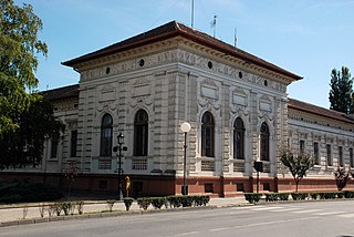
Sremski Karlovci is a town and municipality located in the Srem District of the autonomous province of Vojvodina, Serbia. It is situated on the banks of the Danube, 8 kilometres from Novi Sad. According to the 2022 census results, it has a population of 7,872 inhabitants. The town has traditionally been known as the seat of the Serbian Orthodox Church in the Habsburg Monarchy. It was the political and cultural capital of Serbian Vojvodina after the May Assembly and during the Revolution in 1848.

Vojvodina, officially the Autonomous Province of Vojvodina, is an autonomous province that occupies the northernmost part of Serbia, located in Central Europe. It lies within the Pannonian Basin, bordered to the south by the national capital Belgrade and the Sava and Danube Rivers. The administrative centre, Novi Sad, is the second-largest city in Serbia.

Bečej is a town and municipality located in the South Bačka District of the autonomous province of Vojvodina, Serbia. The town has a population of 19,492, while the municipality has 30,681 inhabitants.

Temerin is a town and municipality located in the South Bačka District of the autonomous province of Vojvodina in Serbia. The town has a population of 17,998, while the municipality has a population of 25,780.
Srbobran is a town and municipality located in the South Bačka District of the autonomous province of Vojvodina, Serbia. The town is located on the north bank of the Danube-Tisa-Danube canal. The town has a population of 10,496, and the municipality of 14,357 according to 2022 census.

Novi Bečej is a town and municipality located in the Central Banat District of the autonomous province of Vojvodina, Serbia. The town has a population of 10,967, while Novi Bečej municipality has 19,886 inhabitants.

Bačko Petrovo Selo is a village located in the Bečej Municipality, in the South Bačka District of Serbia. It is situated in the Autonomous Province of Vojvodina. The village has a Hungarian ethnic majority and its population numbering 7,318 people.

The Serbs of Vojvodina are the largest ethnic group in this northern province of Serbia. For centuries, Vojvodina was ruled by several European powers, but Vojvodina Serbs never assimilated into cultures of those countries. Thus, they have consistently been a recognized indigenous ethnic minority with its own culture, language and religion. According to the 2022 census, there were 1,190,785 Serbs in Vojvodina or 68.43% of the population of the province.

Čurug is a village located in the municipality of Žabalj, Serbia. It is situated in the Autonomous Province of Vojvodina. The village has a Serb ethnic majority and its population numbering 8,166 inhabitants. It is the biggest village in Serbia.

Novo Miloševo is a village located in the Novi Bečej municipality, in the Central Banat District of Serbia. It is situated in the Province of Vojvodina. The village has a Serb majority (76.09%) with an ethnic Hungarian minority (14.57%). Its population is 6,763 people as of the 2002 census.

Bačko Gradište is a village located in the Bečej municipality, in the South Bačka District of Serbia. It is situated in the Autonomous Province of Vojvodina. The village is ethnically mixed and its population numbering 5,445 people. Largest ethnic groups in the village are Hungarians (46.26%) and Serbs (44.39%). Linguistically the village has a Slavophonic plurality as Serbs, Yugoslavs, Croats, Montenegrins and ethnic Muslims collectively compose 49.35% of the population. In early 2007, the village was, among others, affected by the measles outbreak that attracted WHO attention.

The Grgeteg Monastery is a Serb Orthodox monastery on the Fruška Gora mountain in the northern Serbia, in the province of Vojvodina. According to tradition, the monastery was founded by Zmaj Ognjeni Vuk in 1471. The earliest historical records about the monastery date back to 1545/1546. The monastery had been deserted before the 1690 Great Migration of the Serbs, but a renewal, undertaken by Bishop Isaija Đaković, took place in 1708. Around 1770, the extant baroque church was erected and it underwent restoration in 1898 under the guiding hand of Hermann Bollé. It was then that the residential buildings which enclose the church from all four sides were reconstructed. The first walled rocaille iconostasis in the church interior was painted and inlaid by Jakov Orfelin in 1774–1775. The extant iconostasis is a 1902 work of Uroš Predić.

The Divša Monastery, also known as Đipša (Ђипша), is a Serb Orthodox monastery on the Fruška Gora mountain in the northern Serbian province of Vojvodina. It is believed to have been founded by Despot Jovan Branković in the late 15th century. The earliest historical records about the monastery date to the second half of the 16th century. Owing to Turkish raids, the monastery was deserted in the 17th century; at the beginning of the 18th century, Dipša was mentioned as an appendage of the neighbouring Kuveždin monastery. Its old church underwent reconstruction in 1744, but the final alteration was made in 1762, when a new narthex was built. A chapel dedicated to the Mother of God was placed therein, upstairs. The iconostasis for the restored church was carried out by Teodor Stefanov Gologlavac in 1753.

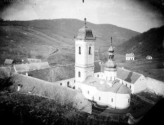
The Novo Hopovo Monastery is a Serb Orthodox monastery on the Fruška Gora mountain in northern Serbia, in the province of Vojvodina. According to tradition, the monastery was built by the Despots of the House of Branković. The first written mention of the monastery was made in 1451, and the latest mention of the monastery dates back to 1641. The extant church was erected in 1576 and the bell-tower with the small St. Stephen's Chapel upstairs was built between 1751 and 1758. The monastic residences were constructed in several stages, from 1728 until 1771. The icons were painted in 1776 by Teodor Kračun.
The Rakovac Monastery is a Serb Orthodox monastery on the Fruška Gora mountain in the northern Serbian province of Vojvodina. The monastery of Rakovac with its church dedicated to the Holy Healers Cosmas and Damian, as tradition has it, was founded by Raka Milošević, Chief Chamberlain to Despot Jovan Branković, according to a legend written in 1704. The legend states that Raka erected the monastery in 1498. The earliest historical records mentioning the monastery are dated to 1545–1546. Inside, there are fragments of the frescoes on the walls which date from the first half of the 16th century. The baroque bell-tower was adjoined in 1735, and the residential building gained its final, three-range shape in 1771. The icons on the baroque iconostasis were painted by Vasa Ostojić in 1763, while the wall paintings in the refectory are 1768 works of Amvrosije Janković.

The Fenek Monastery is the male monastery in the eparchy of Srem of the Serbian Orthodox Church. The monastery is situated near the village of Јаkovo, 25 km from Belgrade, former Municipality of Zemun and now Surčin. Although geographically it does not belong to Fruška gora there is a huge historical connection with Fruška gora monasteries. The monastery church was dedicated to St. Martyr Paraskeva.

The architecture of Serbia has a long, rich and diverse history. Some of the major European style from Roman to Postmodern are demonstrated, including renowned examples of Raška, Serbo-Byzantine with its revival, Morava, Baroque, Classical and Modern architecture, with prime examples in Brutalism and Streamline Moderne.

The Autonomous Province of Vojvodina is an autonomous province of Serbia, located in the northern part of the country, in the Pannonian Plain of Central Europe. Novi Sad is the largest city and administrative center of Vojvodina and the second largest city in Serbia. Vojvodina has a population over 1.93 million. It has a multi-ethnic and multi-cultural identity, with a number of mechanisms for the promotion of minority rights; there are more than 26 ethnic groups in the province, which has six official languages. Most of Vojvodina is a flat terrain, but there are several mountain areas such are Fruška Gora, Vršac Mountains, Titelski Breg, and Zagajička Brda, as well as sandy areas such are Deliblatska Peščara, and Subotička Peščara.

Crna Ćuprija, is a World War II monument in Serbia. It stretches across an area of 472 ha, and it is located 10 km (6.2 mi) from Žabalj near the Tisa River, on the road from Novi Sad to Zrenjanin. The monument was designed by Jovan Soldatović in 1962. At a height of 9 meters (30 ft), the sculptures are dedicated to the victims of the Novi Sad raid killed near Žabalj by fascist Hungarian forces occupying Yugoslavia in January 1942. The memorial is listed as one of the Historic Landmarks of Great Importance in Serbia.

Aksentije Marodić was a Serbian academic painter from Vojvodina.


