Fridtjof Wedel-Jarlsberg Nansen was a Norwegian polymath and Nobel Peace Prize laureate. He gained prominence at various points in his life as an explorer, scientist, diplomat and humanitarian.
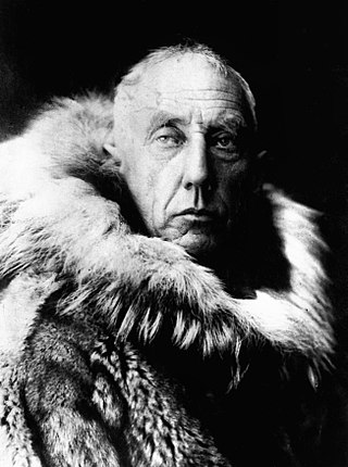
Roald Engelbregt Gravning Amundsen was a Norwegian explorer of polar regions. He was a key figure of the period known as the Heroic Age of Antarctic Exploration.

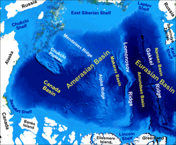
The Gakkel Ridge is a mid-oceanic ridge, a divergent tectonic plate boundary between the North American Plate and the Eurasian Plate. It is located in the Eurasian Basin of the Arctic Ocean, between Greenland and Siberia. Geologically, it connects the northern end of the Mid-Atlantic Ridge with the Laptev Sea Rift.

Fredrik Hjalmar Johansen was a Norwegian polar explorer. He participated on the first and third Fram expeditions. He shipped out with the Fridtjof Nansen expedition in 1893–1896, and accompanied Nansen to notch a new Farthest North record near the North Pole. Johansen also participated in the expedition of Roald Amundsen to the South Pole in 1910–1912.

Fram ("Forward") is a ship that was used in expeditions of the Arctic and Antarctic regions by the Norwegian explorers Fridtjof Nansen, Otto Sverdrup, Oscar Wisting, and Roald Amundsen between 1893 and 1912. It was designed and built by the Scottish-Norwegian shipwright Colin Archer for Fridtjof Nansen's 1893 Arctic expedition in which the plan was to freeze Fram into the Arctic ice sheet and float with it over the North Pole.

The Greenland Sea is a body of water that borders Greenland to the west, the Svalbard archipelago to the east, Fram Strait and the Arctic Ocean to the north, and the Norwegian Sea and Iceland to the south. The Greenland Sea is often defined as part of the Arctic Ocean, sometimes as part of the Atlantic Ocean. However, definitions of the Arctic Ocean and its seas tend to be imprecise or arbitrary. In general usage the term "Arctic Ocean" would exclude the Greenland Sea. In oceanographic studies the Greenland Sea is considered part of the Nordic Seas, along with the Norwegian Sea. The Nordic Seas are the main connection between the Arctic and Atlantic oceans and, as such, could be of great significance in a possible shutdown of thermohaline circulation. In oceanography the Arctic Ocean and Nordic Seas are often referred to collectively as the "Arctic Mediterranean Sea", a marginal sea of the Atlantic.

The research ship had origins in the early voyages of exploration. By the time of James Cook's Endeavour, the essentials of what today we would call a research ship are clearly apparent. In 1766, the Royal Society hired Cook to travel to the Pacific Ocean to observe and record the transit of Venus across the Sun. The Endeavour was a sturdy boat, well designed and equipped for the ordeals she would face, and fitted out with facilities for her research personnel, Joseph Banks. And, as is common with contemporary research vessels, Endeavour carried out more than one kind of research, including comprehensive hydrographic survey work.
The Eurasian Basin, or Eurasia Basin, is one of the two major basins into which the Arctic Basin of the Arctic Ocean is split by the Lomonosov Ridge. The Eurasia Basin may be seen as an extension of the North Atlantic Basin through Fram Strait. It is further split by the mid-ocean Gakkel Ridge into the Nansen Basin and the Amundsen Basin. The latter basin is the deepest one of the Arctic Ocean and the geographic North Pole is located there.
The Molloy Deep is a bathymetric feature in the Fram Strait, within the Greenland Sea east of Greenland and about 160 km west of Svalbard. It is the location of the deepest point in the Arctic Ocean. The Molloy Deep, Molloy Hole, Molloy Fracture Zone, and Molloy Ridge were named after Arthur E. Molloy, a U.S. Navy research scientist who worked in the North Atlantic, North Pacific and Arctic Oceans in the 1950s-1970s.

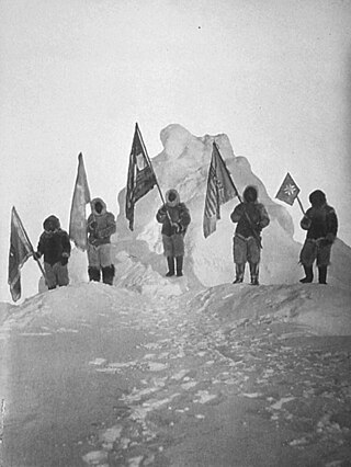
The first ever expedition to reach the Geographic South Pole was led by the Norwegian explorer Roald Amundsen. He and four others arrived at the pole on 14 December 1911, five weeks ahead of a British party led by Robert Falcon Scott as part of the Terra Nova Expedition. Amundsen and his team returned safely to their base, and later heard that Scott and his four companions had died on their return journey.
The Fram Museum is a museum telling the story of Norwegian polar exploration. It is located on the peninsula of Bygdøy in Oslo, Norway.

The Arctic Ocean is the smallest and shallowest of the world's five major oceans. It spans an area of approximately 14,060,000 km2 (5,430,000 sq mi) and is known as one of the coldest of oceans. The International Hydrographic Organization (IHO) recognizes it as an ocean, although some oceanographers call it the Arctic Mediterranean Sea. It has also been described as an estuary of the Atlantic Ocean. It is also seen as the northernmost part of the all-encompassing World Ocean.

The Fram Strait is the passage between Greenland and Svalbard, located roughly between 77°N and 81°N latitudes and centered on the prime meridian. The Greenland and Norwegian Seas lie south of Fram Strait, while the Nansen Basin of the Arctic Ocean lies to the north. Fram Strait is noted for being the only deep connection between the Arctic Ocean and the World Oceans. The dominant oceanographic features of the region are the West Spitsbergen Current on the east side of the strait and the East Greenland Current on the west.

Nansen's Fram expedition of 1893–1896 was an attempt by the Norwegian explorer Fridtjof Nansen to reach the geographical North Pole by harnessing the natural east–west current of the Arctic Ocean. In the face of much discouragement from other polar explorers, Nansen took his ship Fram to the New Siberian Islands in the eastern Arctic Ocean, froze her into the pack ice, and waited for the drift to carry her towards the pole. Impatient with the slow speed and erratic character of the drift, after 18 months Nansen and a chosen companion, Hjalmar Johansen, left the ship with a team of Samoyed dogs and sledges and made for the pole. They did not reach it, but they achieved a record Farthest North latitude of 86°13.6′N before a long retreat over ice and water to reach safety in Franz Josef Land. Meanwhile, Fram continued to drift westward, finally emerging in the North Atlantic Ocean.
Polar exploration is the process of exploration of the polar regions of Earth – the Arctic region and Antarctica – particularly with the goal of reaching the North Pole and South Pole, respectively. Historically, this was accomplished by explorers making often arduous travels on foot or by sled in these regions, known as a polar expedition. More recently, exploration has been accomplished with technology, particularly with satellite imagery.

The Amundsen Basin, with depths up to 4.4 km (2.7 mi), is the deepest abyssal plain in the Arctic Ocean, and contains the geographic North Pole. The Amundsen Basin is embraced by the Lomonosov Ridge and the Gakkel Ridge. It is named after the polar researcher Roald Amundsen. Together with the Nansen Basin, the Amundsen Basin is often summarized as Eurasian Basin.
The Nansen Basin is an abyssal plain with water-depths of around 3 km in the Arctic Ocean and part of the Eurasian Basin. It is named after Fridtjof Nansen. The Nansen Basin is bounded by the Gakkel Ridge on the one side and by the Barents Sea continental shelf on the other.

Thorvald Nilsen was captain of the polar ship, the Fram and deputy commander during Roald Amundsen's expedition to Antarctica (1910–12). While Amundsen conquered the South Pole, the Fram was used for oceanographic observations in the South Atlantic.

Cecilie Mauritzen is a Norwegian physical oceanographer who studies connections between ocean currents and climate change.

The GoNorth project is a series of expeditions into the Central Arctic in 2022 and 2023 with a planned expedition in 2024.