Ardinamir

Last updated

Ardinamir
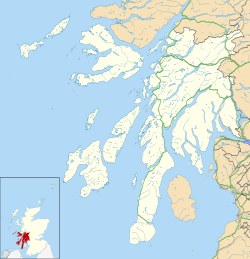
Argyll and Bute UK location map.svg
Red pog.svg
Ardinamir
Location within Argyll and Bute
OS grid reference NM7511
Council area
Country Scotland
Sovereign state United Kingdom
Police Scotland
Fire Scottish
Ambulance Scottish
List of places
UK
Scotland
56°14′N5°38′W / 56.23°N 05.63°W / 56.23; -05.63 Coordinates: 56°14′N5°38′W / 56.23°N 05.63°W / 56.23; -05.63

Ardinamir is an anchorage and small settlement on the island of Luing in Argyll and Bute, Scotland. [1] [2]

The wall of an Iron Age hillfort overlooking the modern settlement at Ardinamir Iron Age hill fort, Ardinamir.jpg
The wall of an Iron Age hillfort overlooking the modern settlement at Ardinamir

Related Research Articles

Ordnance Survey National Grid System of geographic grid references used in Great Britain

The Ordnance Survey National Grid reference system is a system of geographic grid references used in Great Britain, distinct from latitude and longitude.

Baleshare Flat tidal island in the Outer Hebrides of Scotland

Baleshare is a flat tidal island in the Outer Hebrides of Scotland. Baleshare lies to the south-west of North Uist. Its economics and community were boosted by the building of a causeway in 1962. The 350 metres causeway was built by William Tawse Ltd. The island is extremely flat by Hebridean standards, rising to only 12 metres above sea level and known for its long sandy beach. It has a population of 49 living in two settlements: Samhla and Teananachar.

Balta, Shetland

Balta is an uninhabited island in Shetland, Scotland.

Major-General William Roy was a Scottish military engineer, surveyor, and antiquarian. He was an innovator who applied new scientific discoveries and newly emerging technologies to the accurate geodetic mapping of Great Britain. His masterpiece is usually referred to as Roy's Map of Scotland.

A850 road

The A850 road is one of the principal roads of the Isle of Skye in the Inner Hebrides off the west coast of mainland Scotland.

A851 road

The A851 road is one of the principal roads of the Isle of Skye in the Inner Hebrides off the west coast of mainland Scotland.

A863 road

The A863 road is one of the principal roads of the Isle of Skye in the Inner Hebrides off the west coast of mainland Scotland.

Crewe Toll

Crewe Toll is an area in Edinburgh, the Scottish capital.

Luggiebank Human settlement in Scotland

Luggiebank is a small village to the south of Cumbernauld. Like Condorrat, Castlecary and Dullatur, it predates the new town of Cumbernauld, and of those only Condorrat was officially included in the designated area. It is situated on what used to be the Stirling Road from Lanark, but as a result of a bypass (B8039) the old road is now a cul-de-sac. Unlike the rest of Cumbernauld, which was in Dunbartonshire, Luggiebank was historically in Lanarkshire, but was adopted into Dunbartonshire in 1967, prior to Cumbernauld becoming a police burgh the following year. Following further boundary changes in 1995, Luggiebank became part of North Lanarkshire.

Midford Brook

Midford Brook is a small river in Somerset, England.

A961 road

The A961 is a single-carriageway road on the eastern side of Scapa Flow in the Orkney Islands, connecting the town of Kirkwall on the Orkney Mainland to Burwick at the southern end of South Ronaldsay.

Wattston

Wattston is a village on the B803, west of Greengairs in North Lanarkshire, Scotland. Between them Wattston and Greengairs have about 1,190 residents. It is around 4 km south of Cumbernauld, and 4 km north of Airdrie. Other places nearby include Caldercruix, Longriggend, Riggend and Slamannan.

A970 road

The A970 is a single-carriageway road that runs from south to north of Mainland Shetland, Scotland. The road also spurs to Scalloway and North Roe.

Ordnance Survey National mapping agency of the UK for Great Britain

Ordnance Survey (OS) is the national mapping agency for Great Britain. The agency's name indicates its original military purpose, which was to map Scotland in the wake of the Jacobite rising of 1745. There was also a more general and nationwide need in light of the potential threat of invasion during the Napoleonic Wars. Since 1 April 2015 Ordnance Survey has operated as Ordnance Survey Ltd, a government-owned company, 100% in public ownership. The Ordnance Survey Board remains accountable to the Secretary of State for Business, Energy and Industrial Strategy. It was also a member of the Public Data Group.

The Ordnance Survey International or Ordnance Survey Overseas Directorate its predecessors built an archive of air photography, map and survey records for the United Kingdom from 1946 to 1999. The Ordnance Survey International Collection held mapping records that were acquired outside the UK.

Longriggend

Longriggend is a village in North Lanarkshire, Scotland, with a population of approximately 200. It is situated on moorland 8 km north-east of Airdrie, in the parish of New Monkland. It is roughly half way between Upperton and Caldercruix. The village appeared on a map by Timothy Pont, under the name of Langrodge. It was published in 1596 but the letters are difficult to read. The toponymy is listed along with other -rigg placenames. Longriggend is also shown on another map by Roy c1754. Slamannan Railway joined Longriggend with Airdrie and the Union Canal in 1840, but its gauge prevented its connection with the Edinburgh & Glasgow Railway. Coal pits in the area used the railway extensively, and by 1895 there was a station at Longriggend. By 1901 its population had reached over 1500, and it had a post and telegraph office, and an inn nearby.

Stand is a hamlet in North Lanarkshire, Scotland situated on the A73 near Airdrie. Its Ordnance Survey grid reference is NS7668.

Events from the year 1843 in Scotland.

The Ordnance Survey Great Britain County Series maps were produced from the 1840s to the 1890s by the Ordnance Survey, with revisions published until the 1940s. The series mapped the counties of Great Britain at both a six inch and twenty-five inch scale with accompanying acreage and land use information. Following the introduction of the Ordnance Survey National Grid in the 1930s the County Series maps were replaced by a new series of maps at each scale.

References

  1. Ordnance Survey. "View: Sheet 52, Loch Awe - Ordnance Survey One-inch to the mile maps of Great Britain, Seventh Series, 1952-1961". National Library of Scotland. National Library of Scotland . Retrieved 23 January 2016.
  2. "Ardinamir:Overview". Gazetteer for Scotland. Retrieved 21 December 2017.