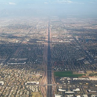
Interstate 17 (I-17) is a north–south Interstate Highway located entirely within the U.S. state of Arizona. I-17's southern terminus lies within Phoenix, at Interstate 10, and its northern terminus is in Flagstaff, at Interstate 40. The majority of I-17 is known as the Arizona Veterans Highway. In the Phoenix metropolitan area, it is mostly known as the Black Canyon Freeway, however the southern 4.16 miles (6.69 km) is part of the Maricopa Freeway. The portion of the highway south of Cordes Lakes was built along the alignment of SR 69, while the northern part was built along old SR 79's alignment. I-17 is one of the most scenic Interstate Highways as it gains more than a mile in altitude between Phoenix at 1,117 feet (340 m) and Flagstaff at 7,000 feet (2,100 m). The highway features several scenic view exits along its route that overlook the many mountains and valleys found in northern Arizona.
U.S. Route 163 is a 64-mile (103 km) U.S. Highway that runs from US 160 northward to US 191 in the U.S. states of Arizona and Utah. The southernmost 44 miles (71 km) of its length are within the Navajo Nation. The highway forms part of the Trail of the Ancients, a National Scenic Byway. The highway cuts through the heart of Monument Valley and has been featured in numerous movies and commercials.

U.S. Route 191 is a spur of U.S. Route 91 that has two branches. The southern branch runs for 1,465 miles (2,358 km) from Douglas, Arizona on the Mexican border to the southern part of Yellowstone National Park. The northern branch runs for 440 miles (710 km) from the northern part of Yellowstone National Park to Loring, Montana, at the Canada–US border. Unnumbered roads within Yellowstone National Park connect the two branches. The highway passes through the states of Arizona, Utah, Wyoming, and Montana.
State Route 89A is an 83.85-mile (134.94 km) state highway that runs from Prescott north to Flagstaff in the U.S. state of Arizona. The highway begins at SR 89 in Yavapai County and heads northward from Prescott, entering Jerome. From Jerome, the route then heads to Cottonwood and Sedona. The highway is notable for its scenic value as it passes through Sedona and the Oak Creek Canyon. The route then enters Coconino County soon after leaving Sedona. The highway proceeds to Flagstaff, where it crosses Interstate 17 (I-17) and I-40. The highway ends at I-40 Business in Flagstaff. What is now SR 89A became a state highway in the late 1920s as SR 79. The highway was extended and improved several times through 1938. SR 79 was renumbered to U.S. Route 89A in 1941 and then to SR 89A in the early 1990s.

U.S. Route 89A is a 91.74-mile (147.64 km) north–south auxiliary U.S. highway in southwestern Kane County, Utah and northeastern Coconino County, Arizona in the southwestern United States. The highway is an old routing of U.S. Route 89 from Bitter Springs, Arizona to Kanab, Utah. The state of Arizona has designated this highway the Fredonia-Vermilion Cliffs Scenic Road. The highway is used to access Grand Canyon National Park and is known for the Navajo Bridge. Until 2008, the Utah portion was signed State Route 11.
State Route 67 is a 43.4 mi (69.8 km) long, north–south state highway in northern Arizona. Also called the Kaibab Plateau – North Rim Parkway, SR 67 is the sole road that links U.S. Route 89A at Jacob Lake to the North Rim of Grand Canyon National Park. Along the route, the road heads through the national park as well as Kaibab National Forest and is surrounded by evergreen trees. The section inside the national park is maintained by the National Park Service (NPS), whereas the section north of the entrance, completely within Kaibab National Forest, is owned by the Arizona Department of Transportation (ADOT). The road was built in the late 1920s and improved through the 1930s. In 1941, the road received its number, and was given its designation as the parkway in the 1980s. The parkway has received designations as a National Forest Scenic Byway as well as a National Scenic Byway.

State Route 64 (SR 64) is a 108.31-mile-long (174.31 km) state highway in the northern part of the US state of Arizona. It travels from its western terminus in Williams to its intersection with U.S. Route 89 (US 89) in Cameron.
State Route 77 is a state highway in Arizona that traverses much of the state's length, stretching from its northern terminus at the boundary of the Navajo Nation north of Holbrook to its junction with I-10 in Tucson.
State Route 73, also known as SR 73, is a U-shaped state highway, though it is signed north–south, primarily serving the Fort Apache Indian Reservation in eastern Arizona. SR 73 begins at a junction with the U.S. Route 60 / State Route 77 concurrency near Carrizo, travels southeast to Fort Apache and Whiteriver, then bends north-northeast until intersecting State Route 260 near the Hon-Dah Resort Casino.

State Route 288 heads north from State Route 188 near Roosevelt Lake. SR 288 ends at Young south of State Route 260. Currently, most of SR 288 is unpaved.
State Route 187, also known as SR 187, is a state highway in south-central Arizona traveling from State Route 387 north of Casa Grande north to its junction with State Route 87 near Sacaton. The entire stretch of road runs in the Gila River Indian Reservation and is approximately 5 miles (8.0 km) long. It is a short-cut for traffic heading toward the southeast valley of Phoenix in case of an accident on westbound Interstate 10.

State Route 261 is a highway in Apache County, Arizona that runs from its junction with SR 260 west of Eagar to its junction with SR 273 north of Big Lake. It winds through the forest but is overall a north–south route.
State Route 264 (SR 264) is a state highway in northeastern Arizona, that runs from a junction with US 160 near Tuba City to the New Mexico state line at Window Rock, where the highway continues as New Mexico State Road 264.

State Route 289 is a highway in Santa Cruz County, Arizona that runs from its junction with Interstate 19 to the north of Nogales, to Peña Blanca Lake. It is an east–west route.
U.S. Route 60 (US 60) is an east–west United States Highway within Arizona. The highway runs for 369 miles (594 km) from a junction with Interstate 10 near Quartzsite to the New Mexico State Line near Springerville. As it crosses the state, US 60 overlaps at various points: I-17, I-10, SR 77, SR 260, US 191, and US 180. Between Wickenburg and Phoenix, the route is known as Grand Avenue. From Tempe to Apache Junction, it is known as the Superstition Freeway.
U.S. Route 93 in the state of Arizona is a United States Numbered Highway that begins in Wickenburg and heads north to the Nevada state line at the Mike O'Callaghan–Pat Tillman Memorial Bridge.

U.S. Route 89 in the U.S. state of Arizona is a U.S. Highway that begins in Flagstaff and heads north to the Utah border northwest of Page.
U.S. Route 89 in the U.S. state of Utah is a north–south United States Highway spanning more than 502 miles (807.891 km) through the central part of the state, making it the longest road in Utah. Between Provo and Brigham City, US-89 serves as a local road, paralleling Interstate 15, but the portions from Arizona north to Provo and Brigham City northeast to Wyoming serve separate corridors. The former provides access to several national parks and Arizona, and the latter connects I-15 with Logan, the state's only Metropolitan Statistical Area not on the Interstate.
Utah State Route 158 is a state highway in the U.S. state of Utah. Spanning 11.6 miles (18.7 km), it connects Powder Mountain Ski Resort and the towns of Liberty and Eden with Utah State Route 39 in Ogden Canyon in Weber County. A portion of the road is designated as part of the Ogden River Scenic Byway.


