Coordinates: 44°21′N38°32′E / 44.350°N 38.533°E

A geographic coordinate system is a coordinate system that enables every location on Earth to be specified by a set of numbers, letters or symbols. The coordinates are often chosen such that one of the numbers represents a vertical position and two or three of the numbers represent a horizontal position; alternatively, a geographic position may be expressed in a combined three-dimensional Cartesian vector. A common choice of coordinates is latitude, longitude and elevation. To specify a location on a plane requires a map projection.


Arkhipo-Osipovka (Russian : Архи́по-О́сиповка) is a rural locality (a selo ) and a Black Sea resort under the jurisdiction of the Town of Gelendzhik in Krasnodar Krai, Russia. Arkhipo-Osipovka (many people call this place Arkhipka) is located 50 kilometers away from the city of Gelendzhik. This place has one of the softest climates on the Russian sea coast. Population: 7,853 (2010 Census); [1] 8,066 (2002 Census); [2] 7,242 (1989 Census). [3]

Russian is an East Slavic language, which is official in the Russian Federation, Belarus, Kazakhstan and Kyrgyzstan, as well as being widely used throughout Eastern Europe, the Baltic states, the Caucasus and Central Asia. It was the de facto language of the Soviet Union until its dissolution on 25 December 1991. Although, nowadays, nearly three decades after the breakup of the Soviet Union, Russian is used in official capacity or in public life in all the post-Soviet nation-states, as well as in Israel and Mongolia, the rise of state-specific varieties of this language tends to be strongly denied in Russia, in line with the Russian World ideology.
The classification system of the types of inhabited localities in Russia, the former Soviet Union, and some other post-Soviet states has certain peculiarities compared with the classification systems in other countries.
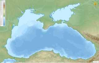
The Black Sea is a body of water and marginal sea of the Atlantic Ocean between the Balkans, Eastern Europe, the Caucasus, and Western Asia. It is supplied by a number of major rivers, such as the Danube, Dnieper, Southern Bug, Dniester, Don, and the Rioni. Many countries drain into the Black Sea, including Austria, Belarus, Bosnia and Herzegovina, Bulgaria, Croatia, Czech Republic, Georgia, Germany, Hungary, Moldova, Poland, Romania, Russia, Serbia, Slovakia, Slovenia, Turkey and Ukraine.
The settlement on the shore of the Vulan Bay originated as the Cossack stanitsa of Vulanovskaya (Вулановская) in 1864. Some twenty-five years later, it was renamed after Arkhip Osipov, a Russian soldier who had sacrificed his life to save his comrades-in-arms from the onslaught of the Circassians in 1840. Arkhipo-Osipovka had urban-type settlement status until 2004.
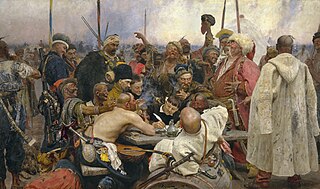
Stanitsa is a village inside a Cossack host (viysko). Stanitsas were the primary unit of Cossack hosts.

The Circassians, also known by their endonym Adyghe, are a Northwest Caucasian nation native to Circassia, many of whom were displaced in the course of the Russian conquest of the Caucasus in the 19th century, especially after the Russo-Circassian War in 1864. In its narrowest sense, the term "Circassian" includes the twelve Adyghe princedoms ; Abdzakh, Besleney, Bzhedug, Hatuqwai, Kabardian, Mamkhegh, Natukhai, Shapsug, Temirgoy, Ubykh, Yegeruqwai and Zhaney, each star on the Circassian flag representing each princedom. However, due to Soviet administrative divisions, Circassians were also designated as the following: Adygeans, Cherkessians, Kabardians and Shapsugians, although all the four are essentially the same people residing in different political units.
Urban-type settlement is an official designation for a semi-urban settlement, used in several Eastern European countries. The term was historically used in Bulgaria, Poland, and the Soviet Union, and remains in use today in 10 of the post-Soviet states.
The vicinity of Arkhipo-Osipovka contains several waterfalls and the scarce remains of an ancient Roman fortification. The economy is dependent on the Beregovaya compressor station, one of the largest in the world, which is part of the Blue Stream pipeline system which carries natural gas from Russia to Turkey and then to Europe.

A waterfall is an area where water flows over a vertical drop or a series of steep drops in the course of a stream or river. Waterfalls also occur where meltwater drops over the edge of a tabular iceberg or ice shelf.
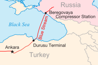
Blue Stream is a major trans-Black Sea gas pipeline that carries natural gas from Russia into Turkey. The pipeline has been constructed by the Blue Stream Pipeline B.V., the Netherlands based joint venture of Russian Gazprom and Italian Eni. The Blue Stream Pipeline B.V. is an owner of the subsea section of pipeline, including Beregovaya compressor station, while Gazprom owns and operates the Russian land section of the pipeline and the Turkish land section is owned and operated by the Turkish energy company BOTAŞ. According to Gazprom the pipeline was built with the intent of diversifying Russian gas delivery routes to Turkey and avoiding third countries.

Turkey, officially the Republic of Turkey, is a transcontinental country located mainly in Western Asia, with a smaller portion on the Balkan Peninsula in Southeast Europe. East Thrace, located in Europe, is separated from Anatolia by the Sea of Marmara, the Bosphorous strait and the Dardanelles. Turkey is bordered by Greece and Bulgaria to its northwest; Georgia to its northeast; Armenia, the Azerbaijani exclave of Nakhchivan and Iran to the east; and Iraq and Syria to the south. Ankara is its capital but Istanbul is the country's largest city. Approximately 70 to 80 per cent of the country's citizens identify as Turkish. Kurds are the largest minority; the size of the Kurdish population is a subject of dispute with estimates placing the figure at anywhere from 12 to 25 per cent of the population.


