Arn Gill (North Yorkshire)

Last updated

Arn Gill
Site of Former Lead Mine, Arn Gill - geograph.org.uk - 242317.jpg
Arn Gill: ravine with former lead mine
North Yorkshire UK relief location map.jpg
Red pog.svg
North Yorkshire
EtymologyArn = "eagle". [1]
Gill = river-cut ravine (northern England). [2]
Location
Country England
County North Yorkshire
Physical characteristics
SourceArn Gill Head, Swaledale
  coordinates 54°23′19.8″N02°07′57.7″W / 54.388833°N 2.132694°W / 54.388833; -2.132694
Mouth  
  location
River Swale
  coordinates
54°23′18.8″N02°08′34.2″W / 54.388556°N 2.142833°W / 54.388556; -2.142833 Coordinates: 54°23′18.8″N02°08′34.2″W / 54.388556°N 2.142833°W / 54.388556; -2.142833
Basin features
LandmarksFormer lead mine and spoil heap
WaterfallsThere are waterfalls near the outfall to the River Swale.
Tributary of River Swale

Arn Gill is a ravine or gully containing a beck of the same name, near the village of Muker in Swaledale, North Yorkshire, England. The ravine and beck run steeply downhill from the stream's source in Arn Gill Head, and the beck disgorges into the River Swale below.

Contents

The ravine contains remnants of the former Adelaide Level lead mine, which is named after Lady Adelaide Lamont, a descendant of Judge Jeffreys. In 1865 a strike was made there, which yielded about £12,000 (equivalent to £1,220,617in 2021) worth of galena or lead ore. The mine closed in 1920. Miners worked in bad conditions in North Yorkshire lead mines during the Adelaide Level's era, with over 62% of local mines having extremely impure air. The most common occupational disease for miners was silicosis.

Description

Arn Gill is located in Swaledale, North Yorkshire, England, north of Muker and on the east side of the River Swale. It is a river-cut ravine or gully, containing a beck, also known as Arn Gill. The beck runs east–west in its gully, falling steeply downhill from its source on the fell Arn Gill Head, to its discharge point as a tributary of the River Swale. [3]

Former lead mining

Adelaide Level was named after Lady Adelaide Lamont Adelaide Lamont nee Denys.jpg
Adelaide Level was named after Lady Adelaide Lamont

Lead mines in the Arn Gill area were worked between 1751 and 1921. [4] However the Adelaide Level lead mine at Arn Gill near Muker was comparatively short-lived. This is the mine of which the remains are still visible. [5]

George Cottingham's strike

Between Keldside and Kisdon are galena ore veins, and the south-eastern ends of these veins run below Arn Gill. Early attempts at mining this source were in 1811 and 1866 at West Arn Gill, which is to the north of Arn Gill, but "no ore was found". There had been drainage works in Arn Gill in the early nineteenth century, for other mines further up the hill. But when the deeper Adelaide Level was driven there, in 1865, a rich vein of ore was found by Sir George Denys' A.D. Company. Muker lead miner George Cottingham (c.1814–1876) and his son George (born c.1850) "hit a rich flat of ore" and according to historians Mike Gill and Edward Fawcett they were said to have thereby brought the company about £12,000 (equivalent to £1,220,617in 2021). [5] [6] Thirty more tons of ore were found in Adelaide Level in 1918. However, by 1920 it was costing too much to pump out water, and the mine was abandoned. [5] [7] [8] The Adelaide Level was named after Lady Adelaide Lamont of Knockdow, daughter of Sir George Denys, [9] [10] and descendant of Judge Jeffreys. [11]

Working conditions

Arn Gill's mine shop and spoil heap, seen from above Remains of Arn Gill Mine geograph-4400072-by-Gordon-Hatton.jpg
Arn Gill's mine shop and spoil heap, seen from above
Arn Gill: the miners' route to work Arn Gill geograph-3577973-by-Gordon-Hatton.jpg
Arn Gill: the miners' route to work

A gill (or ravine) like Arn Gill could facilitate lead mining where the ravine was already cut into the ore vein. That meant that a horizontal tunnel, or adit level, could be dug into the side of the ravine where ore was found. Some of these levels were named horse levels, because they were big enough for a small horse and cart. [12] [13]

In 1864 a commissioned report on the condition of the lead miners of Yorkshire was issued. [14]

The deep valleys ramifying through the hills offer frequent opportunities for driving adit levels at various elevations, by which mode of access all subsequent operations are carried on at a comparatively small expense. An adit level judiciously placed facilitates the drainage and ventilation of the mine; it also affords an easy access for the miners, and egress for the ore by means of wagons running on a tramroad, and propelled either by men or horses, thus saving the labour and expense of raising the products by either steam or water power. In addition to these advantages, the ore is delivered on the banks of a stream, the most convenient place for preparing it for the smelting-house; and should water be required for driving the crushing mills or other machinery, it can ordinarily be obtained from the higher course of the stream; consequently steam power is seldom required and rarely used in this district. The surface of the country in the immediate vicinity of the mines is for the most part wild moorland, and the miners reside in small villages lower down the valleys, and have to walk from two to four miles to and from the mine ... To some extent [this] counteracts the injurious effects of previous exposure to the vitiated atmosphere of the mines. Dr Peacock ... examined 250 miners ... [The most common disease was] miners' asthma. [The miners blame] bad air, powder reek, [nb 1] and stour ... The men have not usually to climb more than 15 to 30 fathoms [or 60 yards (55 metres)] ... He was struck with the most robust appearance of the miners, and the larger proportion of middle-aged and old men among them ... [Dr Peacock indicated a problem with ventilation and "choke damp".] ... In these northern districts, the rates of mortality are much higher among the mining than among the non-mining section of the male population. [In the 110 Northern England mines analysed:] the air was found to be pure or nearly so in 14 or 12.2 per cent, decidedly impure in 27 or 24.54 per cent, and extremely bad in 69 or 62.72 per cent ... In those mines the amount of oxygen was, in one instance, as low as 18.27 per cent, and the carbonic acid amounted in another to 2.26 per cent ... The men are not infrequently small farmers, with gardens attached to their cottages, and ground for the keep of a cow, which enables them to take milk, which they take underground ... The children are not employed to so great an extent at mines, and do not go underground at so early an age as in the South". [14]

Archaeological evidence

The visible evidence of mine works at Arn Gill includes a lead mine lodging shop which survives as a ruined building, [nb 2] and an elling hearth, [nb 3] chopwood kiln, [nb 4] or Q-pit, [nb 5] in the form of a shallow depression and curved pile of stones below the mine shop. [15] [16]

The Yorkshire Mine and Cave Group cleared out and rebuilt the entrance to Adelaide level in 2008–2010, but the inside of the mine is still vulnerable to collapse and flooding. The keystone now in the entrance arch is a replica. The original, engraved with the mine's name and date and discovered by the Cave Group in 1998, is in Swaledale Museum. The museum contains an exhibition related to local lead mining. [9] [10]

Hill walking

Arn Gill is on various hill-walking routes in Swaledale, including one detailed by Swaledale Museum. The interior of Adelaide Level is unsafe, but there are photographs of the mine's interior in the museum. [9]

Notes

  1. Powder reek is noxious fumes from explosives
  2. A mine shop was the mine's office building. A mine lodging shop was the dormitory building where miners slept. The building could also function as both: see Historic England: Park Level mine shop.
  3. An elling hearth was a stone hearth in a shallow depression for burning twigs and vegetation to make potash for processing wool. See DHER: elling hearth
  4. A chopwood kiln was "a type of kiln, usually built into banking, with a stone lining that was used to produce white coal (dried wood) which was used as fuel in the lead smelting process". See DHER: chopwood kiln
  5. A Q-pit was "A kiln in the form of a pit dug into the earth which was used for the production of white coal prior to the Industrial Revolution". See DHER Q pit

Related Research Articles

River Swale River in Yorkshire, England

The River Swale in Yorkshire, England, is a major tributary of the River Ure, which becomes the River Ouse, that empties into the North Sea via the Humber Estuary. The river gives its name to Swaledale, the valley through which it flows.

Derbyshire lead mining history History of lead mining in Derbyshire

This article details some of the history of lead mining in Derbyshire, England.

Swaledale

Swaledale is one of the northernmost dales (valleys) in Yorkshire Dales National Park, located in northern England. It is the dale of the River Swale on the east side of the Pennines in North Yorkshire.

Muker Village and civil parish in North Yorkshire, England

Muker is a village and civil parish at the western end of Swaledale in North Yorkshire, England, within the district of Richmondshire.

Tan Hill, North Yorkshire High point in North Yorkshire, England

Tan Hill is a high point on the Pennine Way in the Richmondshire district of North Yorkshire, England. It lies north of Keld in the civil parish of Muker, near the borders of County Durham and Cumbria, and close to the northern boundary of the Yorkshire Dales National Park. It is in an isolated location, the nearest town of Kirkby Stephen being an 11-mile (18 km) drive away.

Quincy Mine United States historic place

The Quincy Mine is an extensive set of copper mines located near Hancock, Michigan. The mine was owned by the Quincy Mining Company and operated between 1846 and 1945, although some activities continued through the 1970s. The Quincy Mine was known as "Old Reliable," as the Quincy Mine Company paid a dividend to investors every year from 1868 through 1920. The Quincy Mining Company Historic District is a United States National Historic Landmark District; other Quincy Mine properties nearby, including the Quincy Mining Company Stamp Mills, the Quincy Dredge Number Two, and the Quincy Smelter are also historically significant.

Gunnerside Village in North Yorkshire, England

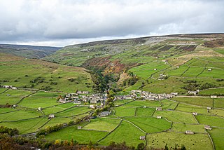
Gunnerside is a village in the Richmondshire district of North Yorkshire, England. It is situated on the B6270 road, 2 miles (3 km) east of Muker and 6 miles (10 km) west of Grinton. The village lies between the River Swale and its tributary, Gunnerside Beck, in the Swaledale part of the Yorkshire Dales National Park.

Arkengarthdale Dale in North Yorkshire, England

Arkengarthdale is a dale, or valley, on the east side of the Pennines in North Yorkshire, England. Running roughly north-west to south-east, it is the valley of the Arkle Beck, and is the northernmost of the Yorkshire Dales. It is a subsidiary dale to Swaledale, which it joins at Reeth. The history of the dale, its people, and farming, lead mining, and local crafts is displayed and documented in the Swaledale Museum in Reeth.

Keld, North Yorkshire Village in North Yorkshire, England

Keld is a village in the English county of North Yorkshire. It is in Swaledale, in the district of Richmondshire and the Yorkshire Dales National Park. The name derives from the Viking word Kelda meaning a spring and the village was once called Appletre Kelde – the spring near the apple trees.

Calver Hill Peak in the Yorkshire Dales, England

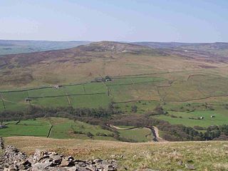
Calver Hill is a fell in the Yorkshire Dales National Park in North Yorkshire, England. It is composed of limestone and is situated at grid reference NZ012003, near where the valleys of Swaledale and Arkengarthdale meet, the village of Reeth is located on its lower south-eastern slopes, it reaches an altitude of 487 metres (1,598 ft) and is a distinguished feature in mid Swaledale. Calver Hill is an area of grouse shooting and the fell is dotted with grouse butts. Most of the drainage from the fell goes north and easterly to join the Arkle Beck in lower Arkengarthdale which eventually joins the River Swale just south of Reeth.

West Stonesdale Hamlet in North Yorkshire, England

West Stonesdale is a hamlet in the Yorkshire Dales, North Yorkshire, England. The secluded village is near Keld to the south, Tan Hill to the north and is both 10 miles (16 km) from Grinton and Askrigg. The small valley that cuts south from Tan Hill to West Stonesdale is also known as West Stonesdale and carries Stonesdale Beck 4 miles (7 km) south to the River Swale. A road heads north from the B6270 through West Stonesdale to Tan Hill. Where the road diverges from the B6270 is the site of Currack Force, a waterfall on Stonesdale Beck which drops 23 feet (7 m) before entering the Swale.

Satron Hamlet in North Yorkshire, England

Satron is a hamlet in Swaledale, North Yorkshire, England. It lies 0.6 miles (1 km) south west of Gunnerside on the opposite bank of the River Swale. It is in the civil parish of Muker, but used to be in the ancient parish of Grinton.

Booze, North Yorkshire Hamlet in North Yorkshire, England

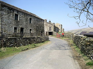
Booze is a hamlet in Arkengarthdale, in the Richmondshire district of North Yorkshire, England. It is about 1 mile (1.6 km) east of Langthwaite. There are 11 households in the hamlet. There is a riding school nearby.

Mining in Roman Britain

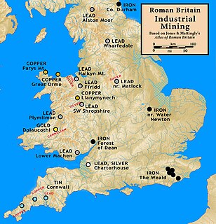
Mining was one of the most prosperous activities in Roman Britain. Britain was rich in resources such as copper, gold, iron, lead, salt, silver, and tin, materials in high demand in the Roman Empire. Sufficient supply of metals was needed to fulfill the demand for coinage and luxury artefacts by the elite.The Romans started panning and puddling for gold. The abundance of mineral resources in the British Isles was probably one of the reasons for the Roman conquest of Britain. They were able to use advanced technology to find, develop and extract valuable minerals on a scale unequaled until the Middle ages.

Gunnerside Gill

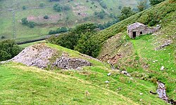
Gunnerside Gill is a small valley in the Yorkshire Dales which branches off Swaledale into moorland to the north of Gunnerside.

Mining in the Upper Harz

Mining in the Upper Harz region of central Germany was a major industry for several centuries, especially for the production of silver, lead, copper, and, latterly, zinc as well. Great wealth was accumulated from the mining of silver from the 16th to the 19th centuries, as well as from important technical inventions. The centre of the mining industry was the group of seven Upper Harz mining towns of Clausthal, Zellerfeld, Sankt Andreasberg, Wildemann, Grund, Lautenthal und Altenau.

Swaledale Museum Museum in North Yorkshire, England

Swaledale Museum is a local museum in the village of Reeth, near Richmond in North Yorkshire, England. It covers rural history including life and work in the local area of Swaledale and Arkengarthdale within the Yorkshire Dales National Park.

Greenside Mine

Greenside Mine was a successful lead mine in the Lake District of England. Between 1825 and 1961 the mine produced 156,000 long tons of lead and 1,600,000 ounces of silver, from around 2 million tons of ore. During the 1940s it was the largest producer of lead ore in the UK. Unusually for a 19th-century metalliferous mine in Britain there are very full records of its activities, dating back to 1825.

Grinton Smelt Mill Lead working site in Yorkshire, England

Grinton Smelt Mill is a ruined lead mining and processing site on Cogden Moor, south of Grinton in Swaledale, North Yorkshire, England. The site was built in its present form c. 1820 for the specific purpose of processing lead won by hushing and hydraulic mining. The buildings and stone flue are now grade II* listed structures and all are scheduled monuments. The site is recognised as being the best preserved lead mining site in the Yorkshire Dales.

Ironstone mining in Cleveland and North Yorkshire Ironstone mines and quarries in Cleveland and North Yorkshire, England

Ironstone mining in Cleveland and North Yorkshire occurred on a sizeable scale from the 1830s to the 1960s in present day eastern parts of North Yorkshire but has been recorded as far back as Roman times in mostly a small-scale and intended for local use. This Cleveland is not to be confused with a smaller area covered by the county of Cleveland from 1974-96.

References

  1. "Arn". nordicnames.de. Nordic Names. Retrieved 3 April 2021.
  2. wikt:gill
  3. "SD911992 or location N.391150, W.499250". streetmap.co.uk. Streetmap. Retrieved 3 April 2021.
  4. "Metaliferrous mines of the Yorkshire Dales". nmrs.org.uk. Northern Mine Research Society. Retrieved 3 April 2021.
  5. 1 2 3 Guy, Helen. "ArnGill and West Stonesdale mines". keld.omeka.net. Keld Resource Centre. Retrieved 3 April 2021.
  6. UK Retail Price Index inflation figures are based on data from Clark, Gregory (2017). "The Annual RPI and Average Earnings for Britain, 1209 to Present (New Series)". MeasuringWorth. Retrieved 11 June 2022.
  7. Gill, Mike (2004). Swaledale: Its Mines and Smelt Mills (2 ed.). London: Landmark. ISBN   9781843061311 . Retrieved 3 April 2021.
  8. Fawcett, Edward R. (1 January 1985). Lead mining in Swaledale (1 ed.). Faust. ISBN   978-0948558009.
  9. 1 2 3 "Swaledale Walk 1 - Muker to Adelaide Level". swaledalemuseum.org/. Swaledale Museum. 2019. Retrieved 5 April 2021.
  10. 1 2 Little, Tracy (Summer 2011). "The Adelaide Level" (PDF). Friends of Swaledale Museum Newsletter (11): 3. Retrieved 5 April 2021.
  11. "Obituary: death of Major Waring's aunt" . Berwickshire News and General Advertiser. British Newspaper Archive. 14 July 1925. p. 3 col.6. Retrieved 5 April 2021.
  12. Roe, Martin (2015). "Lead". outofoblivion.org.uk. Out of Oblivion. Retrieved 3 April 2021.
  13. "Lead mining in the Yorkshire Dales: Early Mining: A Brief History". mylearning.org. My Learning. Retrieved 3 April 2021.
  14. 1 2 "The lead mines of North Yorkshire" . Yorkshire Gazette. British Newspaper Archive. 29 October 1864. p. 2 col.5. Retrieved 4 April 2021.
  15. Laurie, Tim (17 November 2011). "SWAAG ID 337". swaag.org. Swaledale and Arkengarthdale Archaeology Group. Retrieved 3 April 2021.
  16. Barker, L. (1978). "Memoirs 1978" (PDF). British Mining. The Northern Mine Research Society Sheffield UK. 8: 49–54. Retrieved 3 April 2021.

Further reading

Commons-logo.svg Media related to Arn Gill (North Yorkshire) at Wikimedia Commons