
Bougainville, officially the Autonomous Region of Bougainville, is an autonomous region in Papua New Guinea. The largest island is Bougainville Island, while the region also includes Buka Island and a number of outlying islands and atolls. The interim capital is Buka, although this is considered temporary, with the capital likely to move. One potential location is Arawa, the previous capital.

Bougainville Island is the main island of the Autonomous Region of Bougainville, which is part of Papua New Guinea. It was previously the main landmass in the German Empire-associated North Solomons. Its land area is 9,300 km2 (3,600 sq mi). The population of the whole province, including nearby islets such as the Carterets, is approximately 300,000. The highest point is Mount Balbi, on the main island, at 2,715 m (8,907 ft). The much-smaller Buka Island, c. 500 km2 (190 sq mi), lies to the north, across the 400–500 m (1,300–1,600 ft) wide Buka Strait. Even though the strait is narrow, there is no bridge across it, but there is a regular ferry service between the key settlements on either side. The main airport in the north is in the town of Buka.

Rabaul is a township in East New Britain province, on the island of New Britain, in the country of Papua New Guinea. It lies about 600 kilometres to the east of the island of New Guinea. Rabaul was the provincial capital and most important settlement in the province until it was destroyed in 1994 by falling ash from a volcanic eruption in its harbor. During the eruption, ash was sent thousands of metres into the air, and the subsequent rain of ash caused 80% of the buildings in Rabaul to collapse. After the eruption the capital was moved to Kokopo, about 20 kilometres (12 mi) away. Rabaul is continually threatened by volcanic activity, because it is on the edge of the Rabaul caldera, a flooded caldera of a large pyroclastic shield.
Bougainville, an autonomous region of Papua New Guinea (PNG), has been inhabited by humans for at least 29,000 years, according to artefacts found in Kilu Cave on Buka Island. The region is named after Bougainville Island, the largest island of the Solomon Islands archipelago, but also contains a number of smaller islands.

Kieta is a port town located on the eastern coast of the island of Bougainville in Papua New Guinea, near the township of Arawa. After extensive destruction during the 1990 Civil Uprising on Bougainville, Kieta has few inhabitants now, and is known mainly for its transport connections.

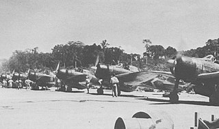
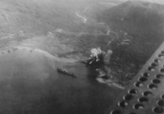
The Bougainville campaign was a series of land and naval battles of the Pacific campaign of World War II between Allied forces and the Empire of Japan, named after the island of Bougainville. It was part of Operation Cartwheel, the Allied grand strategy in the South Pacific. The campaign took place in the Northern Solomons in two phases. The first phase, in which American troops landed and held the perimeter around the beachhead at Torokina, lasted from November 1943 through November 1944.

The Solomon Islands campaign was a major campaign of the Pacific War of World War II. The campaign began with Japanese landings and occupation of several areas in the British Solomon Islands and Bougainville, in the Territory of New Guinea, during the first six months of 1942. The Japanese occupied these locations and began the construction of several naval and air bases with the goals of protecting the flank of the Japanese offensive in New Guinea, establishing a security barrier for the major Japanese base at Rabaul on New Britain, and providing bases for interdicting supply lines between the Allied powers of the United States and Australia and New Zealand.

The New Guinea campaign of the Pacific War lasted from January 1942 until the end of the war in August 1945. During the initial phase in early 1942, the Empire of Japan invaded the Australian-administered Mandated Territory of New Guinea and the Australian Territory of Papua and overran western New Guinea, which was a part of the Netherlands East Indies. During the second phase, lasting from late 1942 until the Japanese surrender, the Allies—consisting primarily of Australian forces—cleared the Japanese first from Papua, then the Mandate and finally from the Dutch colony.

Lae Nadzab Airport is a regional airport located at Nadzab 42 kilometres (26 mi) outside Lae, Morobe Province, Papua New Guinea along the Highlands Highway. It is served by both private and regional aircraft with domestic flights. The airport replaced the Lae Airfield in 1977.

Frans Kaisiepo International Airport, is an airport in Biak, Papua, Indonesia. It is also known as Mokmer Airport. The airport is named after Frans Kaisiepo, the fourth Governor of Papua. The airport has seven aircraft parking slots, of which two are capable of handling wide-body aircraft, and a small terminal without jet bridges. The airport's only runway is 3,571m long, designated as 11/29.

Buka Airport is an airport serving Buka Island in the Autonomous Region of Bougainville in Papua New Guinea.

The Landings at Cape Torokina, also known as Operation Cherryblossom, took place at the beginning of the Bougainville campaign in World War II. The amphibious landings were carried out by elements of the United States Marine Corps in November 1943 on Bougainville Island in the South Pacific, as part of Allied efforts to advance towards the main Japanese base around Rabaul under Operation Cartwheel. Coming in the wake of Allied successes at Guadalcanal and in the central Solomons, the landings were intended to secure a beachhead with the purpose of establishing several bases from which to project air and naval power closer towards Rabaul, in an effort to neutralize the large Japanese force that had been established there.

The 64th Bombardment Squadron is an inactive United States Air Force unit. It was last assigned to the 43d Bombardment Wing at Little Rock Air Force Base, Arkansas, where it was inactivated on 31 January 1970.

Buin is a town on Bougainville Island, and the capital of the South Bougainville District, in the Autonomous Region of Bougainville, in eastern Papua New Guinea. The island is in the northern Solomon Islands Archipelago of the Melanesia region, in the South Pacific Ocean.
Between 9 March and 5 April 1942 during World War II, forces of the Empire of Japan occupied the islands of Buka and Bougainville in the South Pacific. At that time these islands were part of the Australian-administered Territory of New Guinea. A platoon of Australian commandos from the 1st Independent Company was located at Buka Airfield when the Japanese landed but did not contest the invasion.
Bonis Airfield was an aerodrome located on the Bonis Peninsula, Bougainville Island, Papua New Guinea. It was located south of the Buka Passage and Buka Airfield. The airfield was constructed by the Imperial Japanese Navy during World War II in July 1943 as an auxiliary landing strip for Buka Airfield. The airfield was abandoned after the cessation of hostilities.
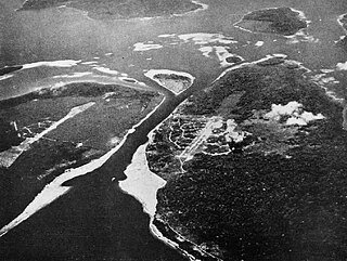
Kahili Airfield, also known as Buin Airfield, was an airfield located near Buin, Bougainville Island, Papua New Guinea.
Rabaul is a town in Eastern New Britain, Papua New Guinea. Japanese forces landed on Rabaul on 23 February 1942, capturing it in February of that year. The former Australian territory was transformed into a major Japanese naval and air installation. The Japanese heavily relied on it, and used it as a launching point for Japanese reinforcements to New Guinea and Guadalcanal. Throughout the Solomons Campaign, neutralizing Rabaul became the primary objective of the Allied effort in the Solomons.
Buin Airport (IATA:UBI) was an airport located near Kara, Bougainville Island, Papua New Guinea.
Justin Hansu Kili, often known as JK, OL MBE was a Papua New Guinean media personality, journalist, activist, and pioneer. His career, which began in the 1970s, spanned radio, television, and print media, including newspapers. Kili served on the boards of directors of numerous organizations, including the Media Council of Papua New Guinea and Transparency International Papua New Guinea (TIPNG).
