
Royal Air Force Aldermaston, or more simply RAF Aldermaston, is a former Royal Air Force station located 8 miles (13 km) east of Newbury, Berkshire and 9.8 miles (15.8 km) southwest of Reading, Berkshire, England.

RAAF Base Townsville is a Royal Australian Air Force (RAAF) air base located in Garbutt, 2 nautical miles west of Townsville in Queensland, Australia. It is the headquarters for No. 1 Wing Australian Air Force Cadets and, along with Lavarack Barracks, establishes Townsville as a key military centre. The base's airfield is shared with the Townsville Airport.

Royal Air Force Shipdham or more simply RAF Shipdham is a former Royal Air Force station located 3 miles south of Dereham, Norfolk, England.

Frans Kaisiepo Airport is an airport on Biak island, in Papua, Indonesia. It is also known as Mokmer Airport. The airport is named after Frans Kaisiepo (1921–1979), the fourth Governor of Papua. The airport has seven aircraft parking slots, of which two are capable of handling wide-body aircraft, and a small terminal without jet bridges. The airport's only runway is 3,571m long, designated as 11/29.

The Landings at Cape Torokina, also known as Operation Cherryblossom, took place at the beginning of the Bougainville campaign in World War II. The amphibious landings were carried out by elements of the United States Marine Corps in November 1943 on Bougainville Island in the South Pacific, as part of Allied efforts to advance towards the main Japanese base around Rabaul under Operation Cartwheel. Coming in the wake of Allied successes at Guadalcanal and in the central Solomons, the landings were intended to secure a beachhead with the purpose of establishing several bases from which to project air and naval power closer towards Rabaul, in an effort to neutralize the large Japanese force that had been established there.

Fenton Airfield was a World War II military airfield in the Northern Territory of Australia located at Tipperary Station in what is now the locality of Douglas-Daly and named after flight lieutenant Clyde Fenton.

Eagle Farm Airport was a small airport located 6 km (3.7 mi) northeast of Brisbane in the suburb of Eagle Farm, Queensland, Australia.

During World War II, the United States Army Air Forces established a series of airfields in Australia for the collective defense of the country, as well as for conducting offensive operations against the Imperial Japanese Army and Navy. From these airports and airfields in Australia, the Fifth Air Force was able to regroup, re-equip and begin offensive operations against the Empire of Japan after the disasters in the Philippines and Dutch East Indies during 1942.
Cape Gloucester Airport is an airport in West New Britain Province, Papua New Guinea.. The airport is a single runway general aviation facility; at the present time there is no scheduled commercial service to the airport.
Saidor Airport is an airport in Madang Province, Papua New Guinea.. It is a general aviation airport located at the coast near Saidor, near Saul Point with Dekys Bay to the east and the Bismarck Sea to the north.
Gusap Airport is a general aviation airport in Morobe Province, Papua New Guinea. located at the base of the Finisterre Range. It has no scheduled commercial airline service. It is currently in use, and maintained by Ramu Agri Industries Ltd. (RAIL) for Crop Dusting purposes.
Wakde Airfield is a World War II airfield located on Wakde Island, off the northern coast of New Guinea in Papua, Indonesia. The airfield was abandoned after the war and today is almost totally returned to its natural state.

Dinjan Airfield, also known as Dinjan Air Force Station, is an air base of Indian Air Force. Established as an air field in World War II, it is located in Dinjan, approximately seven miles northeast of Chabua, in the state of Assam, India.
The Port Moresby Airfield Complex was a World War II military airfield complex, built near Port Moresby in the Territory of Papua and New Guinea. It was used during the Battle of New Guinea as a base of Allied air operations primarily in 1942 and early 1943. It later became a support base as the battle moved to the north and western part of New Guinea. It was closed and the facility turned over to civil authorities after the end of the War in September 1945.
Saint-Dizier-Robinson Air Base is a front-line French Air and Space Force fighter aircraft base located approximately 4 km west of Saint-Dizier, in the Haute-Marne department of the Champagne-Ardenne region in northeastern France.

Taranto-Grottaglie "Marcello Arlotta" Airport is an airport serving Taranto and Grottaglie, both comunes in the province of Taranto in Italy. The airport is located 1.5 kilometres (0.9 mi) from the city of Monteiasi, 4 km (2.5 mi) from Grottaglie and 16 km (9.9 mi) from Taranto. It is named for Marcello Arlotta (1886–1918), an Italian aviator.

Decimomannu Air Base is an Italian Air Force air base located approximately 5 km (2.7 NM) north of Decimomannu a comune in the Province of Cagliari on the island of Sardinia in Italy.

Pontoise Aerodrome or Pontoise–Cormeilles Aerodrome is an airport located 7 km (3.8 NM) northwest of Pontoise in Boissy l'Aillerie near Cormeilles-en-Vexin, all communes of the Val-d'Oise department in the Île-de-France region in northern France. The airport is also located 26 km (16 mi) northwest of Paris.
Aropa Airport is an airport in Kieta, Bougainville Island, Papua New Guinea.
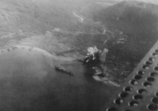
The neutralisation of Rabaul was an Allied campaign to render useless the Imperial Japanese base at Rabaul in eastern New Britain, Papua New Guinea. Japanese forces landed on Rabaul on 23 January 1942, capturing it by February 1942, after which the harbor and town were transformed into a major Japanese naval and air installation. The Japanese heavily relied on it, using it as a launching point for Japanese reinforcements to New Guinea and Guadalcanal. Throughout the Solomon Islands campaign, neutralizing Rabaul became the primary objective of the Allied effort in the Solomons.


