
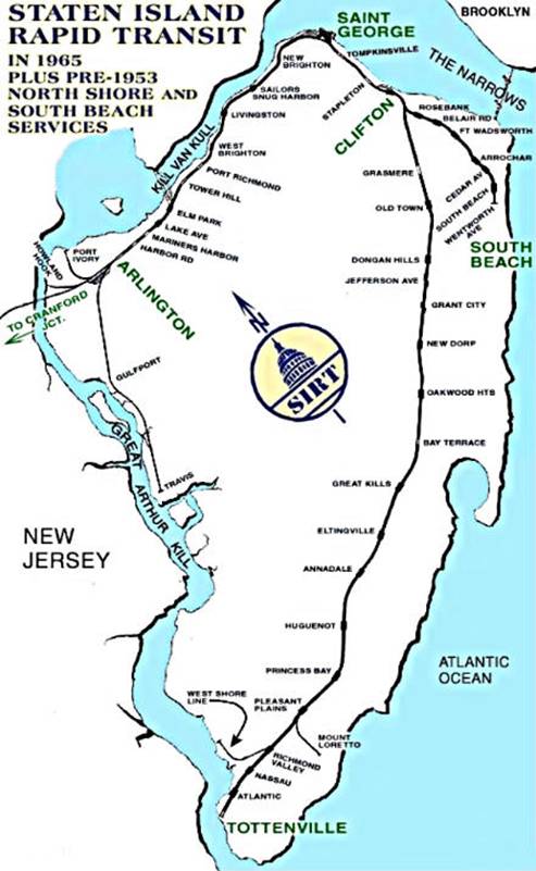
The Staten Island Railway (SIR) is a rapid transit line in the New York City borough of Staten Island. It is owned by the Staten Island Rapid Transit Operating Authority (SIRTOA), a subsidiary of the Metropolitan Transportation Authority, and operated by the New York City Transit Authority Department of Subways. SIR operates 24 hours a day, seven days a week, providing local service between St. George and Tottenville, along the east side of the island. There is currently only one line on the island, and there is no direct rail link between the SIR and the New York City Subway system, but SIR riders do receive a free transfer to New York City Transit bus and subway lines, and the line is included on official New York City Subway maps. Commuters on the railway typically use the Staten Island Ferry to reach Manhattan. The line is accessible from within the Ferry Terminal, and most of its trains are timed to connect with the ferry. In 2022, the system had a ridership of 3,757,700, or about 14,800 per weekday as of the first quarter of 2023.
Mid-Island is frequently applied to a series of neighborhoods within the New York City borough of Staten Island.

South Beach is a neighborhood on the East Shore of Staten Island, New York City, situated directly south of the Verrazzano-Narrows Bridge. South Beach is bounded by New York Bay on the southeast, Seaview Avenue on the southwest, Laconia Avenue on the northwest, Reid and McClean Avenues on the north, and Lily Pond Avenue on the northeast. It is adjacent to Midland Beach to the southwest, Dongan Hills and Old Town/Concord to the northwest, and Fort Wadsworth and Rosebank to the northeast.
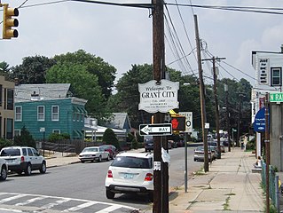
Grant City is the name of a neighborhood located on the East Shore of Staten Island, New York City.

Rosebank is a neighborhood in northeastern Staten Island, one of New York City's five boroughs. It borders Clifton to the north, Arrochar to the south, and the Upper New York Bay to the east.

Woodrow is a neighborhood located on the South Shore of Staten Island, New York, United States. The neighborhood is represented in the New York State Senate by Andrew Lanza, in the New York State Assembly by Michael Reilly, and in the New York City Council by Joe Borelli.

Hylan Boulevard is a major northeast-southwest boulevard in the New York City borough of Staten Island, and the longest street in a single borough in the city. It is approximately 14 miles (23 km) long, and runs from the North Shore neighborhood of Rosebank, then along the entire East Shore, to the South Shore neighborhood of Tottenville. It was renamed in 1923 for New York City mayor John F. Hylan, before which it was known as Southfield Boulevard and the northern segment as Pennsylvania Avenue.

Old Town is a neighborhood in the New York City borough of Staten Island, located on its East Shore. Old Town was established in August 1661 as part of New Netherland, and was the first permanent European settlement on Staten Island. Originally described as "Oude Dorpe", much of its original territory makes up what is present-day South Beach, with parts of Midland Beach and Dongan Hills. The area was settled by a group of Dutch, Walloon and French Protestants (Huguenots) led by Walloon Pierre Billiou.
Wentworth Avenue was a station on the demolished South Beach Branch of the Staten Island Railway. It had one side platform served by one track and was located at Oceanside Avenue and Wentworth Avenue, which has been restored to a Bluebelt wetland since its acquisition by the NYC DEP as part of the South Beach Drainage Plan. Much of the area along the coast nearby has been similarly acquired by city or state agencies in order to allow for storm protection since the devastation wrought by Hurricane Sandy.
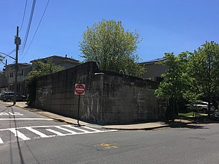
Belair Road is a demolished station on the abandoned South Beach Branch of the Staten Island Railway. It had two side platforms and two tracks, and was located at Vermont Avenue, between Belair Road & St. Johns Avenue. This station served the US Quarantine station, which was one block to the east.
Cedar Avenue was a station on the demolished South Beach Branch of the Staten Island Railway. It had two tracks and two side platforms and was located at Cedar Avenue and Railroad Avenue. It opened in 1931, and closed in 1953.
Arrochar was a station on the demolished South Beach Branch of the Staten Island Railway. It had two side platforms and two tracks and was located at Major Avenue. The station was able to platform two train cars.

Fort Wadsworth was a station on the demolished South Beach Branch of the Staten Island Railway, near the historic Fort Wadsworth. It had two side platforms and two tracks, and was located at Fingerboard Road.

Rosebank is a demolished station in the Rosebank neighborhood along the abandoned South Beach Branch of the Staten Island Railway. It had two tracks and two side platforms, and was located along Tilson Place between Virginia Avenue and St. Mary's Avenue.

South Beach was a station on the demolished South Beach Branch of the Staten Island Railway. It had two tracks and two side platforms, and was located at Sand Lane and Oceanside Avenue.
Bachmann was a station on the demolished South Beach Branch of the Staten Island Railway. Constructed in 1886 to serve the employees of Bachmann's Brewery, it had two tracks and two side platforms, and was located east of Tompkins Avenue, between Lynhurst and Chestnut Avenues. During a grade crossing elimination project on the South Beach Branch, the railroad closed and razed the stop in 1937, due to its proximity to the Rosebank station and the fact that the brewery never reopened after Prohibition. Well after the closure of the Bachmann station, the rest of the South Beach Branch was abandoned in 1953, because of city-operated bus competition.

Father Capodanno Boulevard, formerly Seaside Boulevard, is the primary north-south artery that runs through the Arrochar, South Beach, Ocean Breeze, Midland Beach, and New Dorp Beach neighborhoods of the New York City borough of Staten Island. The boulevard runs parallel to the South Beach Boardwalk and its public park.
Tompkins Avenue is a main artery in northeastern Staten Island New York City. It connects southern Tompkinsville in the north to northern Arrochar in the south, passing through the Fort Wadsworth, Rosebank, Shore Acres, Clifton, and Stapleton neighborhoods. It is mostly a residential street, though it also has commercial districts.

The South Beach Branch, also called the East Shore Sub-Division, is an abandoned branch of the Staten Island Railway in New York City, which operated along Staten Island's East Shore from Clifton to Wentworth Avenue. This 4.1-mile (6.6 km) double-tracked branch left the Main Line at 40°37′08″N74°04′18″W, south of the Clifton station, and lay to the east of the Main Line.
