Woodrow, Staten Island

Last updated
Woodrow United Methodist Church Woodrow U Meth Ch Huguenot jeh.JPG
Woodrow United Methodist Church

Woodrow is a neighborhood located on the South Shore of Staten Island, New York, United States. The neighborhood is represented in the New York State Senate by Andrew Lanza, in the New York State Assembly by Michael Reilly, and in the New York City Council by Joe Borelli.

Contents

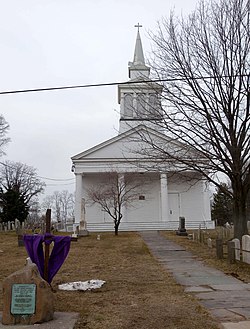
The first Methodist church in the immediate New York City area opened in the neighborhood in 1771. Known today as the Woodrow United Methodist Church, its original congregants included some of the island's earliest well-known families. It was listed on the National Register of Historic Places in 1982. [1]

Long regarded as the western part of Huguenot, pursuant to the custom of old-time Staten Islanders of naming a particular East Shore or South Shore neighborhood after the nearest station on the Staten Island Railway. The Prince's Bay post office is actually located in Woodrow, as well as I.S. 75.[ citation needed ]

Woodrow is part of Staten Island Community District 3 and its ZIP Code is 10312. [2] Woodrow is patrolled by the 123rd Precinct of the New York City Police Department.

Education

Schools

P.S 62 and P.S 56 are located in Woodrow. P.S 3 and P.S 6 are also located near Woodrow. I.S 75, an intermediate school is located in Woodrow. Some intermediate school students living in Woodrow are zoned for I.S 34. St. Thomas-St. Joseph School is a Private Catholic school located near Woodrow. It serves grades Pre-K3-8. [3] The local public High School is Tottenville High School which is located in the Huguenot section of Staten Island. St. Joseph by the Sea High School, a Catholic High School, is located near the neighborhood as well.

Library

New York Public Library, Huguenot Park branch Huguenot NYPL jeh.JPG
New York Public Library, Huguenot Park branch

The New York Public Library (NYPL) operates the Huguenot Park branch at 830 Huguenot Avenue, near the intersection with Drumgoole Road East. The branch opened in January 1985, replacing what was once the smallest New York Public Library building just east of the station (still standing). The Huguenot Park branch was possibly named in honor of the nearby Staten Island Railway station's former name. [4]

Transportation

Woodrow is served by the S56 local bus on Woodrow and Foster Roads; the S55 bus on Bloomingdale Road; and the S74 and S84 on Woodrow Road, Bloomingdale Road, and Rossville Avenue. Express bus service to Manhattan is provided by the SIM25 along Rossville Avenue and Foster Road and the SIM26 along Bloomingdale Road. [5]

The Korean War Veterans Parkway and New York State Route 440 both pass through the neighborhood.

Related Research Articles

<span class="mw-page-title-main">New York State Route 440</span> State highway in Staten Island, New York, US

New York State Route 440 (NY 440) is a state highway located entirely on Staten Island in New York City. The route acts as a connector between the two segments of New Jersey Route 440, running from the Staten Island community of Richmond Valley in the south to Port Richmond in the north. NY 440 is connected to the two New Jersey segments by the Outerbridge Crossing to the south and the Bayonne Bridge to the north. It is one of several signed New York State routes that are not connected to any others in the state, and one of only two NYS routes that is the middle section of another state's highway bearing the same number. Much of NY 440 is a limited-access highway. From the Korean War Veterans Parkway to Interstate 278 (I-278), it is known as the West Shore Expressway. North of I-278, it is named the Dr. Martin Luther King Jr. Expressway. NY 440 is the southernmost state route in the state of New York.

<span class="mw-page-title-main">Mariners Harbor, Staten Island</span>

Mariners Harbor is a neighborhood located in the northwestern part of New York City's borough of Staten Island. It is bordered by Lake Avenue to the east, Forest Avenue to the south, Richmond Terrace to the north, and Holland Avenue to the west. The northwestern section of Mariners Harbor is often known as Arlington.

Prince's Bay is the name of a neighborhood located on the South Shore of New York City's borough of Staten Island. Prince's Bay is bordered to the north by Huguenot, to the south by the Raritan Bay, and to the west by Pleasant Plains. The neighborhood is represented in the New York State Senate by Andrew Lanza, in the New York State Assembly by Michael Reilly, and in the New York City Council by Joe Borelli.

<span class="mw-page-title-main">Charleston, Staten Island</span>

Charleston is a neighborhood, or section, of New York City's borough of Staten Island. It is located on the island's South Shore, with Tottenville to the south, Pleasant Plains to the East, Rossville to the north, and the Arthur Kill to the west. The neighborhood is represented in the New York City Council by Joe Borelli and in the New York State Senate by Andrew Lanza.

<span class="mw-page-title-main">Lemon Creek (Staten Island)</span> Urban stream in Staten Island, New York

Lemon Creek is a stream located on the South Shore of Staten Island in New York City. It is one of the few remaining ground-level creeks in New York City.

<span class="mw-page-title-main">Oakwood, Staten Island</span>

Oakwood is a neighborhood located in east central Staten Island, New York City, near the South Shore. It is bordered by Tysens Lane (north); the Atlantic Ocean (east); Great Kills Park (south); Kensico Street, and Clarke Avenue (west).

<span class="mw-page-title-main">Great Kills, Staten Island</span> Neighborhood of Staten Island in New York City

Great Kills is a neighborhood within the borough of Staten Island in New York City. It is located on the island's South Shore, and according to many local geographers, it is the South Shore's northernmost community. It is bordered by Richmondtown to the north, Bay Terrace to the east, Eltingville to the west, and Great Kills Harbor to the south.

<span class="mw-page-title-main">Eltingville, Staten Island</span> Neighborhood of Staten Island in Richmond, New York, United States

Eltingville is a neighborhood in the Staten Island borough of New York City, United States. It is located on Staten Island's South Shore, immediately to the south of Great Kills and north of Annadale. The main commercial area of Eltingville extends down Richmond Avenue, with offshoots heading north on Amboy Road and Hylan Boulevard. Eltingville is represented in the New York State Senate by Andrew Lanza, in the New York State Assembly by Michael Reilly, and in the New York City Council by Joe Borelli.

<span class="mw-page-title-main">Annadale, Staten Island</span> Neighborhood of New York City

Annadale is a middle-class neighborhood on the South Shore of the borough of Staten Island in New York City.

<span class="mw-page-title-main">Huguenot, Staten Island</span> Neighborhood of Staten Island in New York City

Huguenot is a neighborhood on the South Shore of Staten Island, New York City. Originally named "Bloomingview", it was later named for the Huguenots, led by Daniel Perrin, who settled in the area during the late 17th and early 18th centuries to escape religious persecution. Huguenot is bordered by Arden Heights to the north, Woodrow to the west, Prince's Bay to the south, and Annadale to the east. The neighborhood is represented in the New York City Council by Joe Borelli, who was born and raised there. Huguenot is represented in the New York State Senate by Andrew Lanza and in the New York State Assembly by Michael Reilly.

<span class="mw-page-title-main">Pleasant Plains, Staten Island</span>

Pleasant Plains is a neighborhood located on Staten Island, New York City, New York. It is bordered by Woodrow to the north, the Lower New York Bay to the south, Richmond Valley to the west, and Prince's Bay to the east. The neighborhood is represented in the New York City Council by Joe Borelli.

Westerleigh is a residential neighborhood in the northwestern part of Staten Island in New York City.

Arden Heights is a name increasingly applied to the western part of Annadale, a neighborhood located on the South Shore of Staten Island, New York, USA. The name "Arden Heights" is found on most maps of New York City, including Hagstrom's.

<span class="mw-page-title-main">Rossville, Staten Island</span> Neighborhood of Staten Island in New York City

Rossville is a neighborhood of Staten Island, New York, on the island's South Shore. It is located to the north of Woodrow, to the west of Arden Heights, and to the south and east of the Arthur Kill. Rossville is located within Staten Island Community Board 3.

<span class="mw-page-title-main">Eltingville Transit Center</span> Bus terminal in Staten Island, New York

Eltingville Transit Center is a park and ride transit center that is located in Eltingville, Staten Island. It is located at the intersection of Arthur Kill Road and Richmond Avenue, at the end of the Korean War Veterans Parkway. The transit center was completed in 2004. Amenities include schedules, maps, free parking, and vending machines for soda, snacks, and MetroCards. The center is halfway between the Eltingville Staten Island Railway station and the Staten Island Mall, another transit center, including the adjacent Yukon Depot.

<span class="mw-page-title-main">Bloomingdale Park</span> Public park in Staten Island, New York

Bloomingdale Park is a 138-acre (56 ha) park on the South Shore of Staten Island. It is located in the Prince's Bay neighborhood, and is bounded on the north by Ramona Avenue, on the west by Bloomingdale Road, on the east by Lenevar Avenue, and on the south by Drumgoole Road West and the Korean War Veterans Parkway. It is nearly bisected by Maguire Avenue, but the avenue's two spurs into the park from the north and south do not meet in the middle.

<span class="mw-page-title-main">Old Town, Staten Island</span>

Old Town is a neighborhood in the New York City borough of Staten Island, located on its East Shore. Old Town was established in August 1661 as part of New Netherland, and was the first permanent European settlement on Staten Island. Originally described as "Oude Dorpe", much of its original territory makes up what is present-day South Beach, with parts of Midland Beach and Dongan Hills. The area was settled by a group of Dutch, Walloon and French Protestants (Huguenots) led by Walloon Pierre Billiou.

Arlington is a neighborhood on the North Shore of Staten Island in New York City. It is a subsection of the Mariners' Harbor neighborhood, located north of the North Shore Branch, and west of Harbor Road. Arlington was given its name by Civil War veteran and resident Moses Henry Leman, in recognition of Arlington National Cemetery.

<span class="mw-page-title-main">Arthur Kill Road</span> Avenue in Staten Island, New York

Arthur Kill Road is a major northeast-southwest artery along the South-West Shore of the New York City borough of Staten Island. It is 8.54 miles (13.74 km) long, and runs through the neighborhoods of Tottenville, Richmond Valley, Charleston, Rossville, Woodrow, Huguenot, Arden Heights, Annadale, Eltingville, Greenridge, Great Kills, and Richmondtown.

<span class="mw-page-title-main">New York City's 51st City Council district</span> Place

New York City's 51st City Council district is one of 51 districts in the New York City Council. It has been represented by Republican Joe Borelli since a 2015 special election to replace fellow Republican Vincent Ignizio.

References

  1. "National Register Information System". National Register of Historic Places . National Park Service. July 9, 2010.
  2. "NYC Planning | Community Profiles". communityprofiles.planning.nyc.gov. New York City Department of City Planning. Retrieved March 18, 2019.
  3. "St. Joseph - St. Thomas School - Staten Island, NY". Archived from the original on 2020-09-25. Retrieved 2022-07-25.
  4. "About the Huguenot Park Library". The New York Public Library. Retrieved March 14, 2019.
  5. "Staten Island Bus Map" (PDF). Metropolitan Transportation Authority. January 2020. Retrieved December 1, 2020.

Coordinates: 40°32′36″N74°11′50″W / 40.54333°N 74.19722°W / 40.54333; -74.19722