Related Research Articles
Arrochar is a neighborhood in northeastern Staten Island in New York City in the United States. It is located directly inland of Fort Wadsworth and South Beach, on the east side of Hylan Boulevard south of the Staten Island Expressway; the community of Grasmere borders it on the west. It is today primarily a neighborhood of one- and two-family homes and small businesses.
Prince's Bay is a neighborhood located on the South Shore of New York City's borough of Staten Island. Prince's Bay is bordered to the north by Huguenot, to the south by the Raritan Bay, and to the west by Pleasant Plains. The neighborhood is represented in the New York State Senate by Andrew Lanza, in the New York State Assembly by Michael Reilly, and in the New York City Council by Joe Borelli.
West Shore refers to the section of the New York City borough of Staten Island that borders the Arthur Kill, between the Staten Island Expressway and the Fresh Kills. The Arthur Kill shoreline north of the expressway—most commonly called Port Ivory—is considered part of the North Shore, while the land along the Arthur Kill south of Fresh Kills is generally included within the South Shore.

Oakwood is a neighborhood located in east central Staten Island, New York City, near the South Shore. It is bordered by Tysens Lane (north); the Atlantic Ocean (east); Great Kills Park (south); Kensico Street, and Clarke Avenue (west).

Annadale is a middle-class neighborhood on the South Shore of the borough of Staten Island in New York City.
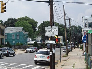
Grant City is a neighborhood located on the East Shore of Staten Island, New York City.

Richmond Valley is a neighborhood located on the South Shore of Staten Island, one of the five boroughs of New York City, the largest city in the United States. Richmond Valley is bordered on the north by Pleasant Plains, to the south by Tottenville, to the west by the Arthur Kill, and to the east by the Lower New York Bay.

Bay Terrace is a neighborhood, centered around the street of the same name, on the East Shore of Staten Island, one of the five boroughs of New York City. It is represented in the New York City Council by Joe Borelli.

Travis is a residential and industrial neighborhood in west-central Staten Island, one of the five boroughs of New York City.
Westerleigh is a residential neighborhood in the north-western part of Staten Island in New York City.
Arden Heights is a name increasingly applied to the western part of Annadale, a neighborhood located on the South Shore of Staten Island, New York City, USA. The name "Arden Heights" is found on most maps of New York City, including Hagstrom's.

Woodrow is a neighborhood located on the South Shore of Staten Island, New York, United States. The neighborhood is represented in the New York State Senate by Andrew Lanza, in the New York State Assembly by Michael Reilly, and in the New York City Council by Joe Borelli.
Bloomfield is a neighborhood on the West Shore of the New York City borough of Staten Island. It lies immediately to the north of Travis-Chelsea and to the west of Bulls Head. Prall's Island is situated in the Arthur Kill off its coast.

Randall Manor is a neighborhood on the North Shore of Staten Island, one of the five boroughs of New York City, United States. The neighborhood is bound by Bard Avenue to the West, Henderson Avenue to the North, Forest Avenue to the South, and Lafayette Avenue to the East. It used to be part of Elliottville.
Shore Acres is a small neighborhood of Staten Island, one of the five boroughs of New York City. It is situated along the Upper New York Bay, just north of Fort Wadsworth and south of Rosebank. Shore Acres is generally considered to be bounded by Bay Street on the west, the Upper New York Bay on the east, Nautilus Street on the north, and Arthur Von Briesen Park on the south.

Livingston is a name sometimes applied to the northeastern portion of West Brighton, a neighborhood located on the North Shore of the New York City borough of Staten Island.

Manor Heights is a neighborhood located in Staten Island, New York City. Manor comes from the fact that the neighborhood is adjacent to Manor Road, a major thoroughfare in the North Shore of Staten Island, and Heights due to the area's sudden elevation within its boundaries. The neighborhood's loose boundaries include the areas south of the Staten Island Expressway, north of Brielle Avenue, which is the location of Susan E. Wagner High School, to the west of Manor Road, and to the east of Bradley Avenue.

MTA Regional Bus Operations operates local and express buses serving New York City in the United States out of 29 bus depots. These depots are located in all five boroughs of the city, plus one located in nearby Yonkers in Westchester County. 21 of these depots serve MTA New York City Transit (NYCT)'s bus operations, while the remaining eight serve the MTA Bus Company These facilities perform regular maintenance, cleaning, and painting of buses, as well as collection of revenue from bus fareboxes. Several of these depots were once car barns for streetcars, while others were built much later and have only served buses.

Old Town is a neighborhood in the New York City borough of Staten Island, located on its East Shore. Old Town was established in August 1661 as part of New Netherland, and was the first permanent European settlement on Staten Island. Originally described as "Oude Dorpe", much of its original territory makes up what is present-day South Beach, with parts of Midland Beach and Dongan Hills. The area was settled by a group of Dutch, Walloon and French Protestants (Huguenots) led by Walloon Pierre Billiou.
Arlington is a neighborhood on the North Shore of Staten Island in New York City. It is a subsection of the Mariners' Harbor neighborhood, located north of the North Shore Branch, and west of Harbor Road. Arlington was given its name by Civil War veteran and resident Moses Henry Leman, in recognition of Arlington National Cemetery.
References
- 1 2 "Chelsea (ii)" in Jackson, Kenneth T., ed. (2010). The Encyclopedia of New York City (2nd ed.). New Haven: Yale University Press. ISBN 978-0-300-11465-2.
- ↑ "Con Ed Acquire Indian Point". The Hastings News. October 14, 1954. Retrieved July 31, 2016– via Fultonhistory.com.
- ↑ "Staten Island Bus Map" (PDF). Metropolitan Transportation Authority. January 2020. Retrieved December 1, 2020.
