
Lake Arrowhead is an unincorporated community and a census-designated place (CDP) in the San Bernardino Mountains of San Bernardino County, California, surrounded by the San Bernardino National Forest, and surrounding the eponymous Lake Arrowhead Reservoir. Lake Arrowhead is located 13 miles north east of the San Bernardino city limits. The population of the CDP was estimated at 12,424 in the 2010 census. It was formerly called "Little Bear Lake", until around 1920, when a group from Los Angeles, the Arrowhead Lake Company, bought the lake and the land surrounding it, and changed its name to Arrowhead Lake.

San Bernardino is a city in and the county seat of San Bernardino County, California, United States. Located in the Inland Empire region of Southern California, the city had a population of 222,101 in the 2020 census, making it the 18th-largest city in California. San Bernardino is the economic, cultural, and political hub of the San Bernardino Valley and the Inland Empire. The governments of El Salvador, Guatemala, and Mexico have established the metropolitan area's only consulates in the downtown area of the city. Additionally, San Bernardino serves as an anchor city to the 3rd largest metropolitan area in California and the 12th largest metropolitan area in the United States; the San Bernardino–Riverside MSA. Furthermore, the city's University District serves as a college town, as home to California State University, San Bernardino.

Arrowhead Stadium is an American football stadium in Kansas City, Missouri, United States. It primarily serves as the home venue of the Kansas City Chiefs of the National Football League (NFL).

Arrowhead Water, also known as Arrowhead Mountain Spring Water, is a brand of drinking water that is sold in the western United States, particularly in Idaho, Nevada, Arizona, Utah, Colorado, New Mexico, Northwestern United States, the Northwest, and in California. It is bottled from 13 springs throughout the Western United States.

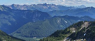
The San Bernardino Mountains are a high and rugged mountain range in Southern California in the United States. Situated north and northeast of San Bernardino and spanning two California counties, the range tops out at 11,503 feet (3,506 m) at San Gorgonio Mountain – the tallest peak in Southern California. The San Bernardinos form a significant region of wilderness and are popular for hiking and skiing.
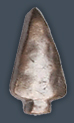
The arrowhead device is a miniature bronze arrowhead that may be worn on campaign, expedition, and service medals and ribbons to denote participation in an amphibious assault landing, combat parachute jump, helicopter assault landing, or combat glider landing by a service member of the United States Army, United States Air Force, or United States Space Force.
The Chiwaukum Mountains are a north–south mountain range in central Washington, United States. They stretch from Snowgrass Mountain at 47°41′N120°56′W, to 47°45′N120°54′W.
The Aviator Glacier is a major valley glacier in Antarctica that is over 60 nautical miles long and 5 nautical miles wide, descending generally southward from the plateau of Victoria Land along the west side of Mountaineer Range, and entering Lady Newnes Bay between Cape Sibbald and Hayes Head where it forms a floating tongue.
Blue Jay is an unincorporated community located in San Bernardino County, California. It is located in the San Bernardino Mountains, above a region of California known as the Inland Empire, and is within the San Bernardino National Forest. Blue Jay Village itself is located one mile from the southwestern bank of Lake Arrowhead.
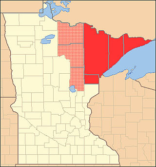
The Arrowhead Region is located in the northeastern part of the U.S. state of Minnesota, so called because of its pointed shape. The predominantly rural region encompasses 10,635.26 square miles (27,545.2 km2) of land area and includes Carlton, Cook, Lake and Saint Louis counties. Its population at the 2000 census was 248,425 residents. The region is loosely defined, and Aitkin, Itasca, and Koochiching counties are sometimes considered as part of the region, increasing the land area to 18,221.97 square miles (47,194.7 km2) and the population to 322,073 residents. Primary industries in the region include tourism and iron mining.
The Arrowhead Trail or Arrowhead Highway was the first all-weather road in the Western United States that connected Los Angeles, California with Salt Lake City, Utah by way of Las Vegas, Nevada. Built primarily during the auto trails period of the 1910s, prior to the establishment of the United States Numbered Highway System, the road was replaced in 1926 by U.S. Route 91 (US 91) and subsequently Interstate 15 (I-15). Small portions of the route in California, Nevada and Utah are sometimes still referred to by the name, or as Arrow Highway.
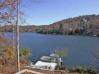
Lake Arrowhead is located approximately two miles (3 km) west of Waleska, in the mountainous, west-northwestern part of Cherokee County, Georgia, United States. Located just east-southeast of Bear Mountain, it is Georgia's second largest man-made, private lake, covering approximately 540 acres (2.2 km2) and reaching depths of up to 80 feet (24 m).
Arrowbear Lake is an unincorporated community in San Bernardino County, California, United States. Its altitude is 6,086 feet (1,855 m) in the San Bernardino Mountains. It is located east of Running Springs along Highway 18 in the San Bernardino National Forest, a mountain community with a population of 736 in 2000.

The former Arrowhead State Park, now known as the Arrowhead Area at Lake Eufaula State Park is a 2,200-acre (8.9 km2) Oklahoma state park area located in northern Pittsburg County, Oklahoma on a peninsula of Eufaula Lake. It is located near the city of Canadian, Oklahoma. Eufaula is one of the largest man-made lakes in the southwest. Arrowhead State Park features 100 tent sites and 91 total RV sites. The park also offers picnic shelters, a marina, playgrounds, trails, miniature golf course, swimming area, mountain biking, equestrian campground, stables, and 25 miles (40 km) of equestrian trails. Group camps with a kitchen and bunkhouses are available and can sleep up to 144 people. Area 51 Marina, which also offers a restaurant, is also located at the park in the Echo Ridge area.
Cedar Glen is an unincorporated community in San Bernardino County, California, United States. This mountain community lies at an elevation of 5403 ft, and is located within the San Bernardino National Forest resort area immediately east of Lake Arrowhead. California State Highway 173 bisects Cedar Glen and passes through Lake Arrowhead.
Crest Park is an unincorporated community in San Bernardino County, California, United States. Crest Park is located in the San Bernardino Mountains on California State Route 18 1 mile (1.6 km) south of Lake Arrowhead. Crest Park had a post office with ZIP code 92326, which opened in 1949.

Skyforest is an unincorporated community in San Bernardino County, California, United States.

BlueTriton Brands, Inc. is an American beverage company based in Stamford, Connecticut. A former subsidiary of Nestlé, it was known between 2002 and 2021 as Nestlé Waters North America, Inc. and operated as the North American business unit of Nestlé Waters. It produces and distributes numerous brands of bottled water across North America including Arrowhead Water, Deer Park Spring Water, Ice Mountain, Pure Life, Splash, Saratoga, Ozarka, Poland Spring, and Zephyrhills.

Arrowhead Ranch is a development in the city of Glendale in Maricopa County, Arizona, United States. It has an estimated elevation of 1,270 feet (390 m) above sea level. Arrowhead Ranch is a former citrus farm. It was purchased for development in 1978 and annexed by Glendale in 1979.
Arrowhead Mountain may refer to:
