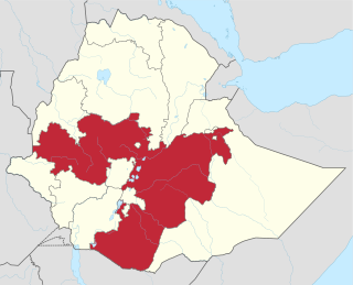
Overview
The altitude of this woreda ranges from 1000 to 2900 meters above sea level; the highest mountains include Weranbus, Abakoro and Dao. Rivers include the Arba, Dagnam Yelew and Bagdo. A survey of the land in this woreda shows that 19.2% is arable or cultivable, 17.9% pasture, 17.1% forest, and the remaining 45.7% is considered swampy, mountainous or otherwise unusable. Arbagugu State Forest is a local landmark. Coffee, khat, bananas and flax are important cash crops. [1]
In the late nineteenth century, about 30% of Ethiopia was covered with forest. The clearing of land for agricultural use and the cutting of trees for fuel gradually changed the scene, and today forest areas have dwindled to less than 4% of Ethiopia's total land. The northern parts of the highlands are almost devoid of trees. However, about 45,000 square kilometres of dense forest exist in the southern and southwestern sections of the highlands. Some of these include coniferous forests, found at elevations above l,600 meters, but a majority of the forestland consists primarily of woodlands found in drier areas of the highlands and in the drier areas bordering the highlands.

Coffee is a brewed drink prepared from roasted coffee beans, the seeds of berries from certain Coffea species. The genus Coffea is native to tropical Africa and Madagascar, the Comoros, Mauritius, and Réunion in the Indian Ocean. Coffee plants are now cultivated in over 70 countries, primarily in the equatorial regions of the Americas, Southeast Asia, Indian subcontinent, and Africa. The two most commonly grown are C. arabica and C. robusta. Once ripe, coffee berries are picked, processed, and dried. Dried coffee seeds are roasted to varying degrees, depending on the desired flavor. Roasted beans are ground and then brewed with near-boiling water to produce the beverage known as coffee.
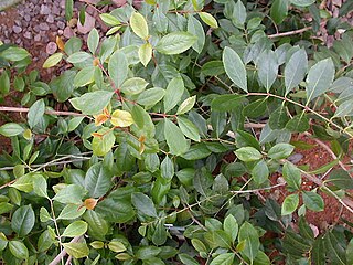
Khat or qat is a flowering plant native to the Horn of Africa and the Arabian Peninsula. Khat contains the alkaloid cathinone, a stimulant, which is said to cause excitement, loss of appetite, and euphoria. Among communities from the areas where the plant is native, khat chewing has a history as a social custom dating back thousands of years analogous to the use of coca leaves in South America and betel nut in Asia.
Industry in the woreda includes one grain mill and some mining, as well as 83 licensed traders of whom 71% were retailers, 26.5% wholesalers and 2.5% service providers. According to the Government of Oromia, "Aseko is the [most] disadvantaged district in industrial activities in Arsi zone." There were 13 Farmers Associations with 9669 members. [1] Aseko has no reported roads, and is reportedly only accessible during the dry season; due to this inaccessibility, the woreda was largely excluded from rural development programs between 1974-1984. [2] However, 27 kilometers of road connecting Abomsa in Merti to Aseko was reported as under construction in 2005. About 19% of the total population has access to drinking water. [1]

Mining is important to the economy of Ethiopia as a diversification from agriculture. Currently, mining comprises only 1% of GDP. Gold, gemstones, and industrial minerals are important commodities for the country's export-oriented growth strategy. Tantalum mining has also been profitable. It was reported that in the late 1980s, the mineral industry lacked importance given that it contributed less than 0.2 percent of Ethiopia's GDP. Mining for gold is a key development sector in the country. Gold export, which was just US$5 million in 2001, has recorded a large increase to US$602 million in 2012.

Abomsa is a town in central Ethiopia; Traditionally the Etymology of the word Abomsa is ʔabbo /Abbo/ and mɨsɑ. Abbo is the short form of the Name Saint Abune Gebre Menfes Kiduss and popularly called Abbo and mɨsa is lunch. In the early period, the people who preceded at that place celebrated a memorial day for the Abune Gebre Menfes Kiduss, and after the lunch, they said we had the lunch in the name of Abbo, then they named the place Abbomɨsa. Located in the Arsi Zone of the Oromia Region, the town has a latitude and longitude of 8°35′N39°51′E and an altitude of 1438 meters. It is the administrative center of Merti woreda.

Access to water supply and sanitation in Ethiopia is amongst the lowest in Sub-Saharan Africa and the entire world. While access has increased substantially with funding from foreign aid, much still remains to be done to achieve the Millennium Development Goal of halving the share of people without access to water and sanitation by 2015, to improve sustainability and to improve service quality.
Demographics
The 2007 national census reported a total population for this woreda of 84,112, of whom 42,399 were men and 41,713 were women; 3,988 or 4.74% of its population were urban dwellers. The majority of the inhabitants said they were Muslim, with 62.83% of the population reporting they observed this belief, while 36.89% of the population practised Ethiopian Orthodox Christianity. [3]

Islam is the second largest religion in Ethiopia with over 33,9% of the population practicing it in 2007. The faith arrived in Ethiopia at an early date, shortly before the hijira. Islam is the religion of the overwhelming majority of the Somali, Afar, Argobba, Harari, Berta, Alaba, and Silt'e and also has many adherents among the Gurage and the Oromo, the largest ethnic group in Ethiopia, as well as a minority of Amhara, the second largest ethnic group in the country.
Based on figures published by the Central Statistical Agency in 2005, this woreda has an estimated total population of 84,959, of whom 41,940 are men and 43,019 are women; 1,961 or 2.31% of its population are urban dwellers, which is less than the Zone average of 12.3%. With an estimated area of 618.13 square kilometers, Aseko has an estimated population density of 137.4 people per square kilometer, which is greater than the Zone average of 132.2. [4]
The 1994 national census reported a total population for this woreda of 61,513, of whom 31,327 were men and 30,186 women; 1,097 or 1.78% of its population were urban dwellers at the time. The two largest ethnic groups reported in Aseko were the Oromo (59.49%), and the Amhara (40.08%); all other ethnic groups made up 0.43% of the population. Oromiffa was spoken as a first language by 55.62%, and 44.35% spoke Amharic; the remaining 0.03% spoke all other primary languages reported. The majority of the inhabitants were Muslim, with 54.53% of the population having reported they practiced that belief, while 45.38% of the population said they professed Ethiopian Orthodox Christianity. [5]

The Oromo people are an ethnic group inhabiting Ethiopia. They are one of the largest ethnic groups in Ethiopia and represent 34.5% of Ethiopia's population. Oromos speak the Oromo language as a mother tongue, which is part of the Cushitic branch of the Afro-Asiatic language family. The word Oromo appeared in European literature for the first time in 1893 and then slowly became common in the second half of the 20th century.

Oromo is an Afroasiatic macrolanguage which is primarily composed of four distinct languages: Southern Oromo which includes the Gabra and Sakuye dialects, Eastern Oromo, Orma which includes the Munyo, Orma, Waata/Sanye dialects, and West–Central Oromo. Like Arabic, Oromo is a dialect continuum so language varieties spoken in neighbouring regions differ only slightly, but the differences accumulate over distance so that widely separated varieties are not mutually intelligible.
Jeju is one of the woredas in the Oromia Region of Ethiopia. Part of the Arsi Zone, Jeju is bordered by Dodotana Sire to the west, the Misraq Shewa Zone to the north, Merti to the east, and Sude to the south. Its administrative centre is Arboye, located 168 kilometres southeast of Addis Ababa. Other towns in this woreda include Bolo.
Nono is one of the woredas in the Oromia Region of Ethiopia. It is named after the Nono Oromo, a subgroup of the Macha Oromo, who live in this area. Part of the West Shewa Zone, Nono is bordered on the southwest by the Gibe River which separates it from the Jimma Zone, on the northwest by Dano, on the north by Cheliya, on the northeast by Tikur, on the east by the Southwest Shewa Zone, and on the southeast by the Southern Nations, Nationalities and Peoples Region. Jibat woreda was part of Nono woreda.
Guba Koricha is one of the woredas in the Oromia Region of Ethiopia. Located in the Mirab Hararghe Zone, Guba Koricha, according to the OCHA map (2005) is bordered on the south by Darolebu, on the southwest by the Arsi Zone, on the west by the Afar Region, on the north by Mieso, on the northeast by Chiro, on the east by Habro, and on the southeast by Boke. Woreda of Anchar was separated from Guba Koricha.
Darolebu is one of the woredas in the Oromia Region of Ethiopia. Part of the Mirab Hararghe Zone, Darolebu is bordered on the south by the Shebelle River which separates it from the Bale Zone, on the west by the Arsi Zone, on the northwest by Guba Koricha, on the north by the Habro, and on the east by Boke. Towns in Darolebu include Machara and Micheta.
Adami Tullu and Jido Kombolcha is one of the woredas in the Oromia Region of Ethiopia. Part of the Misraq Shewa Zone located in the Great Rift Valley, Adami Tullu and Jido Kombolcha is bordered on the south by Mirab Arsi Zone with which it shares the shores of Lakes Abijatta and Langano, on the west by the Southern Nations, Nationalities and Peoples Region, on the north by Dugda Bora, on the northeast by Lake Zway, and on the east by the Arsi Zone. The main town of woreda is Adami Tullu; other towns include Abosa, Bulbulla, and Jido.
Arsi Negele is one of the woredas in the Oromia Region of Ethiopia. It is named after its administrative center, Arsi Negele. Part of the Mirab Arsi Zone located in the Great Rift Valley, Arsi Negele is bordered on the south by Shashamene Zuria, on the southwest by Lake Shala which separates it from Shala, on the west from the Southern Nations, Nationalities and Peoples Region, on the north by Misraq Shewa with which it shares the shores of Lakes Abijatta and Langano, and on the east by the Arsi Zone.
Merti is one of the woredas in the Oromia Region of Ethiopia. Part of the Arsi Zone, Merti is bordered on the south by Sude, on the west by Jeju, on the northwest by the Misraq Shewa Zone, on the north by the Afar Region, on the east by Aseko, and on the southeast by Chole. The administrative center of this woreda is Abomsa; other towns in Merti include Reye. Guna woreda was separated from Merti.
Gololcha is one of the woredas in the Oromia Region of Ethiopia. Part of the Arsi Zone, Gololcha is bordered on the south by Amigna, on the west by Chole, on the northwest by Aseko, and on the north and east by the Mirab (West) Hararghe Zone. The administrative center of this woreda is Chancho; other towns include TimugaJinga bilu,Kella, Haro kambela,Mine&Unke.
Hitosa is one of the woredas in the Oromia Region of Ethiopia. Woreda of Lude Hitosa was separated from Hitosa. Part of the Arsi Zone, Hitosa is bordered on the south by Digeluna Tijo, on the southwest by Tiyo, on the west by Ziway Dugda, on the northwest by the Misraq Shewa Zone, on the northeast by Dodotana Sire, and on the east by Tena. The administrative center of the woreda is Iteya; other towns include Borujawi and Ligaba.
Sude is one of the woredas in the Oromia Region of Ethiopia. Part of the Arsi Zone, Sude is bordered on the south by Robe, on the southwest by Tena, on the west by Dodotana Sire, on the northwest by Jeju, on the north by Merti, on the northeast by Chole and on the southeast by Amigna. The administrative center of the woreda is Kula.
Chole is one of the woredas in the Oromia Region of Ethiopia. Part of the Arsi Zone, Chole is bordered on the south by Amigna, on the southwest by Sude, on the northwest by Merti, on the north by Aseko, and on the east by Gololcha. Towns in Chole include Chole and Moye.
Amigna is one of the woredas in the Oromia Region of Ethiopia. Part of the Arsi Zone, Amigna is bordered on the south by Seru, on the southwest by Robe, on the west by Sude, on the northwest by Chole, on the north by Gololcha, and on the east by the Mirab (West) Hararghe Zone. Towns include Adele.
Seru is one of the woredas in the Oromia Region of Ethiopia. It is named after the woreda capital, Seru. Part of the Arsi Zone, Seru is bordered on the south and east by the Shebelle River which separates it from the Bale Zone, on the west by the Wabe River which separates it from Robe, on the north by Amigna, and on the northeast by the Mirab (West) Hararghe Zone. Woreda of Bale Gasegar was separated form Seru.
Tena is one of the woredas in the Oromia Region of Ethiopia. Diksis woreda was separated form Tena woreda. Part of the Arsi Zone, Tena is bordered on the south by Sherka, on the southwest by Bekoji, on the west by Digeluna Tijo, on the northwest by Hitosa, on the north by Dodotana Sire, on the northeast by Sude, and on the east by Robe. The administrative center of the woreda is Ticho; other towns in Tena include Kela.
Digeluna Tijo is one of the woredas in the Oromia Region of Ethiopia. Part of the Arsi Zone, Digeluna Tijo is bordered on the south by Bekoji, on the southwest by Munesa, on the northwest by Tiyo, on the north by Hitosa, on the northeast by Tena, and on the east by Sherka. The administrative center of this woreda is Sagure; other towns include Tijo and Digelu.
Tiyo is one of the woredas in the Oromia Region of Ethiopia. Part of the Arsi Zone, Tiyo is bordered on the south by Munesa, on the west by Ziway Dugda, on the northeast by Hitosa, and on the southeast by Digeluna Tijo. The administrative center of the woreda and Zone is Asella; other towns in Tiyo include Gonde.
Jarso is one of the woredas in the Oromia Region of Ethiopia. Part of the Misraq (East) Hararghe Zone, Jarso is bordered on the south by the Harari Region, on the west by Kombolcha, on the north by the city of Dire Dawa, on the east by the Somali Region, and on the southeast by Gursum. The administrative center of this woreda is Ejersa Goro.
Meta is one of the woredas in the Oromia Region of Ethiopia. Part of the Misraq (East) Hararghe Zone, Meta is bordered on the southwest by Deder, on the northwest by Goro Gutu, on the north by the Somali Region, on the northeast by Kersa, and on the southeast by Bedeno. Towns in Meta include Chelenqo and Kulubi.
Gololcha is one of the woredas in the Oromia Region of Ethiopia. It was part of former Gaserana Gololcha woreda what was divided for Gadera and Gololcha woredas. Part of the Bale Zone, Gaserana Gololcha is bordered on the south by Ginir, on the southwest by Sinanana Dinsho, on the west by Agarfa, on the north by the Shebelle River which separates it from the Arsi Zone, on the northeast by Legehida, and on the east by Seweyna. The administrative center for the woreda is Jara.
Guna is one of the woredas in the Oromia Region of Ethiopia. It is part of the Arsi Zone. It was separated from Merti woreda.