Demographics
The 2007 national census reported a total population for this woreda of 47,929, of whom 24,125 were men and 23,804 were women; 3,174 or 6.62% of its population were urban dwellers. The majority of the inhabitants said they were Muslim, with 83.72% of the population reporting they observed this belief, while 16.08% of the population practised Ethiopian Orthodox Christianity. [2]

Islam is the second largest religion in Ethiopia with over 33% of the population practicing it. The statistics in the latest version of the CIA World Factbook are taken from the 1994 national census although this percentage is disputed by the Muslim community. The faith arrived in Ethiopia at an early date, shortly before the hijira. Islam is the religion of the overwhelming majority of the Somali, Afar, Argobba, Harari, Berta, Alaba, and Silt'e and also has many adherents among the Gurage and the Oromo, the largest ethnic group in Ethiopia, as well as a minority of Amhara, the second largest ethnic group in the country.
Based on figures published by the Central Statistical Agency in 2005, this woreda has an estimated total population of 112,183, of whom 56,642 are men and 55,541 are women; 7,733 or 6.89% of its population are urban dwellers, which is less than the Zone average of 12.3%. With an estimated area of 2,361.57 square kilometers, Seru has an estimated population density of 47.5 people per square kilometer, which is less than the Zone average of 132.2. [3]
The 1994 national census reported a total population for this woreda of 80,358, of whom 40,007 were men and 40,351 women; 4,334 or 5.39% of its population were urban dwellers at the time. The two largest ethnic groups reported in Seru were the Oromo (93.64%), and the Amhara (6.08%); all other ethnic groups made up 0.28% of the population. Oromiffa was spoken as a first language by 90.62%, and 5.86% spoke Amharic; the remaining 3.52% spoke all other primary languages reported. The majority of the inhabitants were Muslim, with 63% of the population having reported they practiced that belief, while 36.8% of the population said they professed Ethiopian Orthodox Christianity. [4]

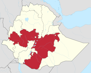
The Oromo people are an ethnic group inhabiting Ethiopia. They are one of the largest ethnic groups in Ethiopia and represent 34.5% of Ethiopia's population. Oromos speak the Oromo language as a mother tongue, which is part of the Cushitic branch of the Afro-Asiatic language family. The word Oromo appeared in European literature for the first time in 1893 and then slowly became common in the second half of the 20th century.

Oromo is an Afroasiatic macrolanguage which is primarily composed of four distinct languages: Southern Oromo which includes the Gabra and Sakuye dialects, Eastern Oromo, Orma which includes the Munyo, Orma, Waata/Sanye dialects, and West–Central Oromo. Like Arabic, Oromo is a dialect continuum so language varieties spoken in neighbouring regions differ only slightly, but the differences accumulate over distance so that widely separated varieties are not mutually intelligible.
Nono is one of the woredas in the Oromia Region of Ethiopia. It is named after the Nono Oromo, a subgroup of the Macha Oromo, who live in this area. Part of the West Shewa Zone, Nono is bordered on the southwest by the Gibe River which separates it from the Jimma Zone, on the northwest by Dano, on the north by Cheliya, on the northeast by Tikur, on the east by the Southwest Shewa Zone, and on the southeast by the Southern Nations, Nationalities and Peoples Region. Jibat woreda was part of Nono woreda.
Darolebu is one of the woredas in the Oromia Region of Ethiopia. Part of the Mirab Hararghe Zone, Darolebu is bordered on the south by the Shebelle River which separates it from the Bale Zone, on the west by the Arsi Zone, on the northwest by Guba Koricha, on the north by the Habro, and on the east by Boke. Towns in Darolebu include Machara and Micheta.
Degem is one of the woredas in Semien Shewa Zone of Oromiya Region in Ethiopia. Degem is bordered on the south by Muger River which separates it from Misraq Welega Zone, on the west by Kuyu, on the northwest by Hidabu Abote, on the north by Jamma River which separates it from Amhara Region, on the northeast by Gerar Jarso, and on the east by Yaya Gulele and Debre Libanos. Towns in Degem include Alidoro and Anbiso.
Gerar Jarso is one of the woredas in the Oromia Region of Ethiopia. Part of the Semien Shewa Zone, Gerar Jarso is bordered on the south by Yaya Gulelena Debre Liban, on the west by Degem, and on the east by the Amhara Region.
Adami Tullu and Jido Kombolcha is one of the woredas in the Oromia Region of Ethiopia. Part of the Misraq Shewa Zone located in the Great Rift Valley, Adami Tullu and Jido Kombolcha is bordered on the south by Mirab Arsi Zone with which it shares the shores of Lakes Abijatta and Langano, on the west by the Southern Nations, Nationalities and Peoples Region, on the north by Dugda Bora, on the northeast by Lake Zway, and on the east by the Arsi Zone. The main town of woreda is Adami Tullu; other towns include Abosa, Bulbulla, and Jido.
Arsi Negele is one of the woredas in the Oromia Region of Ethiopia. It is named after its administrative center, Arsi Negele. Part of the Mirab Arsi Zone located in the Great Rift Valley, Arsi Negele is bordered on the south by Shashamene Zuria, on the southwest by Lake Shala which separates it from Shala, on the west from the Southern Nations, Nationalities and Peoples Region, on the north by Misraq Shewa with which it shares the shores of Lakes Abijatta and Langano, and on the east by the Arsi Zone.
Aseko is one of the woredas in the Oromia Region of Ethiopia. It is named after the administrative center of the woreda, Aseko. Part of the Arsi Zone, Aseko is bordered on the southwest by Chole, on the northwest by Merti, on the north by the Mirab (West) Hararghe Zone, and on the east by Gololcha.
Sude is one of the woredas in the Oromia Region of Ethiopia. Part of the Arsi Zone, Sude is bordered on the south by Robe, on the southwest by Tena, on the west by Dodotana Sire, on the northwest by Jeju, on the north by Merti, on the northeast by Chole and on the southeast by Amigna. The administrative center of the woreda is Kula.
Amigna is one of the woredas in the Oromia Region of Ethiopia. Part of the Arsi Zone, Amigna is bordered on the south by Seru, on the southwest by Robe, on the west by Sude, on the northwest by Chole, on the north by Gololcha, and on the east by the Mirab (West) Hararghe Zone. Towns include Adele.
Robe is one of the woredas in the Oromia Region of Ethiopia. It is named after the Robe River, 80 kilometers of which flows through the woreda. Part of the Arsi Zone, Robe is bordered on the south by the Shebelle River which separates it from the Bale Zone, on the southwest by Sherka, on the west by Tena, on the north by Sude, on the northeast by Amigna, and on the east by Seru. The administrative center of the woreda is Robe; other towns in Robe include Habe and Sedika.
Sherka is one of the woredas in the Oromia Region of Ethiopia. Research by Ulrich Braukämper uncovered a local tradition that traced the origins of this woreda's name to an ancient Ethiopian province, Sharkha, which vanished as a political unit in the 16th century. Part of the Arsi Zone, Sherka is bordered on the south by the Shebelle River which separates it from the Bale Zone, on the southwest by Bekoji, on the west by Digeluna Tijo, on the north by Tena, and on the east by Robe. Gobesa is the administrative center; other towns include Gado Guna.
Tiyo is one of the woredas in the Oromia Region of Ethiopia. Part of the Arsi Zone, Tiyo is bordered on the south by Munesa, on the west by Ziway Dugda, on the northeast by Hitosa, and on the southeast by Digeluna Tijo. The administrative center of the woreda and Zone is Asella; other towns in Tiyo include Gonde.
Kokosa is one of the woredas in the Oromia Region of Ethiopia. Being part of the Mirab Arsi Zone, Kokosa is bordered on the south and west by the Southern Nations, Nationalities and Peoples Region, on the north by the Kofele, on the northeast by Dodola, and on the southeast by Nensebo. The administrative center of this woreda is Kokosa; other towns include Diki, Gata, Hebano, Hogiso.
Agarfa is one of the woredas in the Oromia Region of Ethiopia, named for its administrative center, Agarfa. Located in the northwestern corner of the Bale Zone, Agarfa is bordered on the south by Sinanana Dinsho, on the west by Mirab Arsi Zone, on the north by the Shabelle River which separates it from the Arsi Zone, and on the east by Gaserana Gololcha. Other towns in Agarfa include Ali.
Gololcha is one of the woredas in the Oromia Region of Ethiopia. It was part of former Gaserana Gololcha woreda what was divided for Gadera and Gololcha woredas. Part of the Bale Zone, Gaserana Gololcha is bordered on the south by Ginir, on the southwest by Sinanana Dinsho, on the west by Agarfa, on the north by the Shebelle River which separates it from the Arsi Zone, on the northeast by Legehida, and on the east by Seweyna. The administrative center for the woreda is Jara.
Ginir is one of the woredas in the Oromia Region of Ethiopia. It is named after the administrative center of the woreda, Ginir. Part of the Bale Zone, Ginir is bordered on the south by the Gestro River which separates it from Goro, on the west by Sinanana Dinsho, on the northwest by Gaserana Gololcha, on the northeast by Seweyna, and on the east by Raytu. Towns include Delo Serbo.
Goba is one of the woredas in the Oromia Region of Ethiopia. It is named after the town of Goba. Part of the Bale Zone, Goba is bordered on the south by Mennana Harena Buluk, on the west by Mirab Arsi Zone, on the north by the Mena River which separates it from Sinanana Dinsho, and on the southeast by Berbere.
Meda Welabu is one of the woredas in the Oromia Region of Ethiopia. Part of the Bale Zone, Meda Welabu is bordered on the south by the Ganale Dorya River which separates it from the Guji Zone, on the northwest by Mirab Arsi Zone, on the north by Mennana Harena Buluk, and on the northeast by Guradamole. The administrative center of the woreda is Bidire; other towns in Meda Welabu include Oborso.
Berbere is one of the woredas in the Oromia Region of Ethiopia. Part of the Bale Zone, Berbere is bordered on the south by Mennana Harena Buluk, on the northwest by Goba, on the north by Sinanana Dinsho, on the northeast by Goro, and on the east by Guradamole; the Mena River separates it from Shinanana Dinsho and Goro. The administrative center of the woreda is Haro Dumal.
Bale Gasegar is one of the woredas in the Oromia Region of Ethiopia. It is part of the Arsi Zone. It was separated from Seru woreda.