
The Pudding River is a 62-mile (100 km) tributary of the Molalla River in the U.S. state of Oregon. Its drainage basin covers 528 square miles (1,368 km2). Among its tributaries are Silver Creek, Butte Creek, Abiqua Creek, and the Little Pudding River.
Marys River is a 40-mile (64 km) tributary of the Willamette River in the U.S. state of Oregon. From its source at the confluence of its east and west forks near Summit, it flows generally southeast from the Central Oregon Coast Range to Corvallis.

The McKenzie River is a 90-mile (145 km) tributary of the Willamette River in western Oregon in the United States. It drains part of the Cascade Range east of Eugene and flows westward into the southernmost end of the Willamette Valley. It is named for Donald McKenzie, a Scottish Canadian fur trader who explored parts of the Pacific Northwest for the Pacific Fur Company in the early 19th century. As of the 21st century, six large dams have been built on the McKenzie and its tributaries.

The Smith River is a 90-mile (140 km) tributary of the Umpqua River in the U.S. state of Oregon. It drains 352 square miles (910 km2) of the Central Oregon Coast Range between the watershed of the Umpqua to the south and the Siuslaw River to the north.

The Luckiamute River is a tributary of the Willamette River, about 61 miles (98 km) long, in western Oregon in the United States. It drains an area of Central Oregon Coast Range and the western Willamette Valley northwest of Corvallis.

The Alsea River flows 48.5 miles (78.1 km) from Alsea, an unincorporated community in the coastal mountains of the U.S. state of Oregon, to the Pacific Ocean near the city of Waldport. It begins at the confluence of the North Fork Alsea River and the South Fork Alsea River and ends in Alsea Bay, a wide estuary at Waldport. The river flows generally west-northwest in a winding course through the mountains of southern Benton and Lincoln counties, passing near the unincorporated community of Tidewater and through the Siuslaw National Forest. Its drainage basin extends into Lane County, along the headwaters of the South Fork Alsea River.

The Big River is a tributary of the Coast Fork Willamette River, approximately 12 miles (19 km) long, in western Oregon in the United States. It drains an area of the Calapooya Mountains south of Eugene.
The Trask River is in northwestern Oregon in the United States. It drains a mountainous timber-producing area of the Northern Oregon Coast Range west of Portland into Tillamook Bay and the Pacific Ocean. It is one of five rivers—the Tillamook, the Trask, the Wilson, the Kilchis, and the Miami—that flow into the bay.

The South Santiam River is a tributary of the Santiam River, about 69 miles (111 km) long, in western Oregon in the United States. It drains an area of the Cascade Range into the Willamette Valley east of Corvallis.
The Middle Santiam River is a tributary of the South Santiam River, 38.5 miles (62.0 km) long, in western Oregon in the United States. It drains a remote area of the Cascade Range east of Sweet Home in the watershed of the Willamette River.
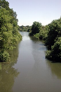
Abiqua Creek is a tributary of the Pudding River in the U.S. state of Oregon. The creek originates near Lookout Mountain in the foothills of the Cascade Range in the northwestern part of the state. It flows northwest for about 29 miles (47 km) to its confluence with the Pudding, about 2 miles (3.2 km) west of Silverton, in the Willamette Valley. About 20 miles (32 km) north of Silverton, the Pudding River meets the Molalla River, which meets the Willamette River less than 1 mile (1.6 km) later near Canby.

The Oregon Coast Range, often called simply the Coast Range and sometimes the Pacific Coast Range, is a mountain range, in the Pacific Coast Ranges physiographic region, in the U.S. state of Oregon along the Pacific Ocean. This north-south running range extends over 200 miles (320 km) from the Columbia River in the north on the border of Oregon and Washington, south to the middle fork of the Coquille River. It is 30 to 60 miles wide and averages around 1,500 feet (460 m) in elevation above sea level. The coast range has three main sections, a Northern, Central, and Southern.

The Middle Fork Willamette River is one of several forks that unite to form the Willamette River in the western part of the U.S. state of Oregon. It is approximately 115 miles (185 km) long, draining an area of the Cascade Range southeast of Eugene, which is at the southern end of the Willamette Valley.
Dairy Creek is a 10.55-mile (16.98 km) tributary of the Tualatin River in the U.S. state of Oregon. It begins at the confluence of its east and west forks near the unincorporated community of Schefflin and meanders southeast across the Tualatin Valley to the Tualatin River near Hillsboro, in Washington County. East Fork Dairy Creek begins at 45.788446°N 123.041498°W in Columbia County, slightly north of its border with Washington County, and flows generally south for 22 miles (35 km). West Fork Dairy Creek, also about 22 miles (35 km) long, forms at 45.7553899°N 123.178168°W, near the unincorporated community of Tophill, and flows generally southeast. Before railroads displaced river boats on the Tualatin, some steamships also worked the lower section of Dairy Creek, with plans to go as far up stream as Centerville.

Pringle Creek is a small tributary of the Willamette River that drains a 15-square-mile (39 km2) area of Marion County in the U.S. state of Oregon. The entire watershed lies within the urban growth boundary of the City of Salem. Pringle Creek's tributaries include Clark Creek, West Fork Pringle Creek, West Middle Fork and East Fork.

Hills Creek is a tributary, about 16 miles (26 km) long, of the Middle Fork Willamette River in the U.S. state of Oregon. From its headwaters on Juniper Ridge in the Cascade Range, the creek flows northwest through Lane County and the Willamette National Forest for its entire course.

Salt Creek is a tributary, 30 miles (48 km) long, of the Middle Fork Willamette River in Lane County in the U.S. state of Oregon. It is named for salt springs along its banks that are used as licks by deer. The stream originates as an outflow of Lower Betty Lake in the forested Cascade Range just southeast of Waldo Lake. From its source, Salt Creek flows generally south, through Gold Lake, to Route 58, which it then follows mainly northwest for about 26 miles (42 km) to its mouth at the Middle Fork Willamette River just below Hills Creek Dam. At Salt Creek Falls—roughly 4 miles (6.4 km) west of Willamette Pass and a little more than 22 miles (35 km) upstream from the mouth—the stream plunges 286 feet (87 m), discharging an average of 50,000 U.S. gallons (190,000 L) of water per minute, or 111 cubic feet per second (3.1 m3/s). Below the falls, the creek enters a narrow canyon shaped by glaciation and basalt lava flows from higher in the Cascades. McCredie Hot Springs, at the former community of McCredie Springs, are natural hot springs along the lower half of Salt Creek beside Route 58.
Roaring River is a 13.7-mile (22.0 km) tributary of the Clackamas River in Clackamas County, Oregon. Beginning near Signal Buttes on the western flank of the Cascade Range, the river flows generally west through parts of Mount Hood National Forest to meet the larger river 44 miles (71 km) from its mouth on the Willamette River.
Ritner Creek is a tributary of the Luckiamute River in Polk County in the U.S. state of Oregon. The creek begins near Bald Mountain in the Central Oregon Coast Range and flows generally southeast to meet the Luckiamute southwest of Pedee and north of Kings Valley. The confluence is 31 miles (50 km) upstream of the Luckiamute's mouth on the Willamette River. Named tributaries of Ritner Creek from source to mouth are Sheythe, Love, Clayton, and Kinsey creeks.

