
Calvert County is a county located in the U.S. state of Maryland. As of the 2020 census, the population was 92,783. Its county seat is Prince Frederick. The county's name is derived from the family name of the Barons of Baltimore, the proprietors of the English Colony of Maryland. Calvert County is included in the Washington–Arlington–Alexandria, DC–VA–MD–WV Metropolitan Statistical Area. It occupies the Calvert Peninsula, which is bordered on the east by Chesapeake Bay and on the west by the Patuxent River. The county has one of the highest median household incomes in the United States. It is one of the older counties in Maryland, after St. Mary's, Kent County and Anne Arundel counties. The county is part of the Southern Maryland region of the state.

Lusby is an unincorporated community and census-designated place (CDP) in Calvert County, Maryland, United States. The population of the CDP was 1,835 at the 2010 census. Residents of the Chesapeake Ranch Estates and Drum Point communities also use the Lusby ZIP code designation.

Cecil Calvert, 2nd Baron Baltimore was an English nobleman / peer, politician, and lawyer who was the first proprietor of Maryland. Born in Kent, England in 1605, he inherited the proprietorship of overseas colonies in Avalon (Newfoundland), along with Maryland after the 1632 death of his father, George Calvert, 1st Baron Baltimore (1580-1632), for whom it had been originally intended in a vast land grant from King Charles I. Young Calvert proceeded to establish and manage the Province of Maryland as a proprietary colony for English Catholics from his English country house of Kiplin Hall in North Yorkshire.

Baron Baltimore, of Baltimore, County Longford, was a title in the Peerage of Ireland. It was created in 1625 and ended in 1771, upon the death of its sixth-generation male heir, aged 40. Holders of the title were usually known as Lord Baltimore for short.

Southern Maryland, also referred to as SoMD, is a geographical, cultural and historic region, as well as a National Heritage Area, in Maryland composed of the state's southernmost counties on the Western Shore of the Chesapeake Bay. According to the state of Maryland, the region includes all of Calvert, Charles, and St. Mary's counties and the southern portions of Anne Arundel and Prince George's counties. It is largely coterminous with the region of Maryland that is part of the Washington metropolitan area. Portions of the region are also part of the Baltimore Metropolitan Area and the California-Lexington Park Metropolitan Statistical Area. As of the 2020 Census, the region had a population of 373,177. The largest community in Southern Maryland is Waldorf, with a population of 81,410 as of the 2020 Census.
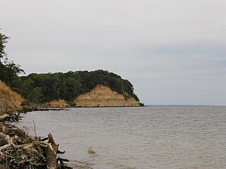
Calvert Cliffs State Park is a public recreation area in Lusby, Calvert County, Maryland, that protects a portion of the cliffs that extend for 24 miles along the eastern flank of the Calvert Peninsula on the west side of Chesapeake Bay from Chesapeake Beach southward to Drum Point. The state park is known for the abundance of mainly Middle Miocene sub-epoch fossils that can be found on the shoreline.

Maryland Route 2 is the longest state highway in the U.S. state of Maryland. The 79.24-mile (127.52 km) route runs from Solomons Island in Calvert County north to an intersection with U.S. Route 1 /US 40 Truck in Baltimore. The route runs concurrent with MD 4 through much of Calvert County along a four-lane divided highway known as Solomons Island Road, passing through rural areas as well as the communities of Lusby, Port Republic, Prince Frederick, and Huntingtown. In Sunderland, MD 2 splits from MD 4 and continues north as two-lane undivided Solomons Island Road into Anne Arundel County, still passing through rural areas. Upon reaching Annapolis, the route runs concurrent with US 50/US 301 to the north of the city. Between Annapolis and Baltimore, MD 2 runs along the Governor Ritchie Highway, a multilane divided highway that heads through suburban areas, passing through Arnold, Severna Park, Pasadena, Glen Burnie, and Brooklyn Park. In Baltimore, the route heads north on city streets and passes through the downtown area of the city.

Maryland Route 4 is a state highway in the U.S. state of Maryland. The highway runs 64.85 miles (104.37 km) from MD 5 in Leonardtown north to Southern Avenue in Suitland at the District of Columbia boundary, beyond which the highway continues into Washington as Pennsylvania Avenue. MD 4 is a four- to six-lane highway that connects Washington and communities around Interstate 95 (I-95)/I-495 with southern Prince George's County with southwestern Anne Arundel County. The highway is the primary highway for the length of Calvert County, during most of which the route runs concurrently with MD 2. MD 4 also connects Calvert and St. Mary's counties via the Governor Thomas Johnson Bridge across the Patuxent River. The highway connects the Southern Maryland county seats of Leonardtown, Prince Frederick, and Upper Marlboro.

The Calvert Cliffs Nuclear Power Plant (CCNPP) is a nuclear power plant located on the western shore of the Chesapeake Bay near Lusby, Calvert County, Maryland, in the Mid-Atlantic United States. It is the only nuclear power plant in the state of Maryland.
The Chesapeake Ranch Estates (CRE), also known locally as the Ranch Club, is located in Lusby, Maryland, United States, in southern Calvert County. CRE was founded in 1958 and is governed by a homeowners' association, which is officially called the "Property Owner's Association of the Chesapeake Ranch Estates" (POACRE). Today, CRE is composed of over 4,000 homes. The community is counted as a census-designated place for population statistics, with a residential population of 10,519 as of the 2010 census. At the 2000 census, the area was part of the Chesapeake Ranch Estates-Drum Point CDP.

Maryland Route 765 is a collection of state highways in the U.S. state of Maryland. These 26 highways are service roads constructed or old alignments maintained to provide access to private property or county highways whose access was compromised by the realignment of MD 2 and MD 4 in Calvert County. There are six signed mainline segments of MD 765 comprising the old alignment of the concurrency of MD 2 and MD 4 through Solomons, Lusby, St. Leonard, and Port Republic, and the county seat of Prince Frederick in southern Calvert County. There are also 20 unsigned sections of MD 765 south of Prince Frederick and along MD 2 between its junction with MD 4 in Sunderland and Owings in northern Calvert County.
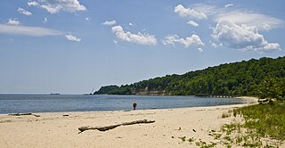
Flag Ponds Nature Park is a nature preserve located in Lusby, Maryland along the Chesapeake Bay in Calvert County, Maryland. It is operated by the Calvert County Department of Natural Resources. The park includes nature trails and a beach for swimmers. Fossil shark's teeth eroded from the Calvert Cliffs formation may be collected on the beach. The area included in the park was once a center for pound net fishing from the early 1900s through 1955. One fishing shanty remained until October 2012 when it burned down. It has since been rebuilt.

Maryland Route 509 is a state highway in the U.S. state of Maryland. Known for most of its length as Governor Run Road, the state highway runs 1.14 miles (1.83 km) from MD 2/MD 4 east to a dead end at the Chesapeake Bay within Port Republic. MD 509 was constructed east from what is now MD 765 in the early 1930s. The highway was extended west to MD 2/MD 4 in the early 1980s.
The St. Marys Formation is a geologic formation in Maryland and Virginia, United States. It preserves fossils dating back to the Miocene Epoch of the Neogene period. It is the youngest Miocene formation present in the Calvert Cliffs and is part of the Chesapeake Group.
Araeodelphis is an extinct genus of river dolphin from the early Miocene of the East Coast of the United States.
Phocageneus is an extinct genus of river dolphin belonging to Squalodelphinidae. Specimens have been found in the middle Miocene Calvert Formation of Maryland and Virginia.

Astroscopus, the electric stargazers, is a genus of stargazers, a type of percomorph fish from the family Uranoscopidae, part of the order Labriformes. The species in this genus are anatomically distinct uranoscopids, being characterized by internal nares and being the only group of marine bony fish having organs which produce electricity which are derived from the extraocular muscles. They are found on the Atlantic and Pacific coasts of the Americas.

The Calvert Formation is a geologic formation in Maryland, Virginia, and Delaware. It preserves fossils dating back to the early to middle Miocene epoch of the Neogene period. It is one of the three formations which make up the Calvert Cliffs, all of which are part of the Chesapeake Group.
