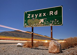
Zzyzx, formerly Soda Springs, is an unincorporated community in San Bernardino County, California, United States, within the boundaries of the Mojave National Preserve, managed by the National Park Service (NPS), an agency of the U.S. Department of Interior, as public land. It is the former site of the Zzyzx Mineral Springs and Health Spa and now the site of the Desert Studies Center. The site is also the location of Lake Tuendae, originally part of the spa, and now a refuge habitat of the endangered Mohave tui chub.

The Kelso Mountains are located just north of the small community of Kelso and the Kelso Dunes, in the Mojave National Preserve in southeastern California. The town of Baker, near Interstate 15, lies approximately 18 miles (29 km) to the northwest of the mountain range. Kelso Peak, at 4,764 feet, is the principal peak of the range. Like most of the Mojave Desert, the range is characterized by little rainfall, and usually receives less than 5–6 inches (125–150 mm) of precipitation in a normal year.

The Vallecito Mountains are located in the Colorado Desert, in eastern San Diego County, Southern California. They are about 28 miles (45 km) north of the U.S. border with Mexico.

The Bigelow Cholla Garden Wilderness is in the eastern Mojave Desert and within Mojave Trails National Monument, located in San Bernardino County, California.

Telescope Peak is the highest point within Death Valley National Park, in the U.S. state of California. It is also the highest point of the Panamint Range, and lies in Inyo County. From atop this desert mountain one can see for over one hundred miles in many directions, including west to Mount Whitney, and east to Charleston Peak. The mountain was named for the great distance visible from the summit.

Leggett is a census-designated place in Mendocino County, California, United States. It is located on the South Fork of the Eel River, 21 miles (34 km) by road northwest of Laytonville, at an elevation of 984 ft (300 m). It is home to some of the largest trees in the world. The nearby Smithe Redwoods State Natural Reserve and Standish-Hickey State Recreation Area are noted for their forests of coastal redwoods. The population of Leggett was 77 at the 2020 census, down from 122 at the 2010 census.
Granite Springs is an unincorporated community in Mariposa County, California. It is located 3 miles (4.8 km) southwest of Penon Blanco Peak, at an elevation of 1417 feet.
Cummings is an unincorporated community in Mendocino County, California. It is located near U.S. Route 101 on Rattlesnake Creek 5 miles (8 km) east-southeast of Leggett, at an elevation of 1329 feet.
Hardy is an unincorporated community in Mendocino County, California. It is located on California State Route 1 near the Pacific coast 5.25 miles (8.4 km) north of Westport, at an elevation of 23 feet.
Kibesillah is an unincorporated community in Mendocino County, California. It is located on California State Route 1 near the Pacific coast 3.25 miles (5.2 km) south of Westport, at an elevation of 138 feet.
Longvale is an unincorporated community in Mendocino County, California. It is located on Outlet Creek adjacent to the Northwestern Pacific Railroad and U.S. Route 101 9.5 miles (15 km) south-southeast of Laytonville, at an elevation of 1191 feet.
Nashmead is an unincorporated community in Mendocino County, California. It is located on the Eel River and Northwestern Pacific Railroad 4 miles (6.4 km) south-southeast of Spyrock, at an elevation of 814 feet.
Newport is an unincorporated community in Mendocino County, California. It is located on California State Route 1 near the Pacific Ocean 4.25 miles (6.8 km) south of Westport, at an elevation of 135 feet.
Riverdale is an unincorporated community in Mendocino County, California. It is located near U.S. Route 101 on the South Fork of the Eel River 2.25 miles (3.6 km) northwest of Leggett, at an elevation of 732 feet.

Gabilan Acres is an unincorporated community in Monterey County, California. It is located on San Juan Grade Road northeast of Salinas and Bolsa Knolls and 6.5 miles (10 km) west of Fremont Peak, at an elevation of 203 feet. The Gabilan Acres subdivision was laid out in 1940 and planned as a race-restricted community. By 1948 the neighborhood had 48 homeowners and children attended school in nearby Santa Rita. In 1964, The Californian newspaper recognized Gabilan as one of nine unincorporated subdivisions outside Salinas, along with Santa Rita, Oak Park, San Juan Acres, Bolsa Knolls, Spreckels, Pedrazzi, Pine Canyon, and San Benancio. In 1998 an 11-year-old girl was killed in her home in Gabilan Acres.
Zuver is an unincorporated community in Placer County, California. Zuver is located 3 miles (4.8 km) west-northwest of Devil Peak. It lies at an elevation of 3921 feet.

Cirque Peak is a 12,900-foot-elevation (3,900-meter) mountain summit located on the crest of the Sierra Nevada mountain range in California. It is situated on the common border of Tulare County with Inyo County, as well as the shared boundary of Golden Trout Wilderness and John Muir Wilderness, on land managed by Inyo National Forest. It is 14 miles (23 km) southwest of the community of Lone Pine, 7.7 miles (12.4 km) south-southeast of Mount Whitney, and 3.2 miles (5.1 km) south of Mount Langley, the nearest higher neighbor. Cirque Peak is the highest point of the Golden Trout Wilderness, and ranks as the 175th highest peak in California. Topographic relief is significant as it rises 1,800 feet above Cirque Lake in approximately one mile. The Pacific Crest Trail traverses the southwest slope of this mountain, providing an approach option. The mountain was apparently named in 1890 by Joseph Nisbet LeConte and companions who noted the remarkable cirque on the north aspect.


