
Wine Country is the region of California, in the northern San Francisco Bay Area, known worldwide as a premier wine-growing region. The region is famed for its wineries, its cuisine, Michelin star restaurants, boutique hotels, luxury resorts, historic architecture, and culture. Viticulture and wine-making have been practiced in the region since the Spanish missionaries from Mission San Francisco Solano established the first vineyards in 1812.

San Pablo Bay is a tidal estuary that forms the northern extension of San Francisco Bay in the East Bay and North Bay regions of the San Francisco Bay Area in northern California.
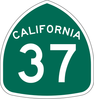
State Route 37 is a state highway in the U.S. state of California that runs 21 miles (34 km) along the northern shore of San Pablo Bay. It serves as a vital connection in the North Bay region of the San Francisco Bay Area, running from U.S. Route 101 in Novato, through northeastern Marin County, and the southern tips of both Sonoma and Solano Counties to Interstate 80 in Vallejo. Sonoma Raceway and Six Flags Discovery Kingdom are accessible from Highway 37.
Sonoma Creek is a 33.4-mile-long (53.8 km) stream in northern California. It is one of two principal drainages of southern Sonoma County, California, with headwaters rising in the rugged hills of Sugarloaf Ridge State Park and discharging to San Pablo Bay, the northern arm of San Francisco Bay. The watershed drained by Sonoma Creek is roughly equivalent to the wine region of Sonoma Valley, an area of about 170 square miles (440 km2). The State of California has designated the Sonoma Creek watershed as a “Critical Coastal Water Resource”. To the east of this generally rectangular watershed is the Napa River watershed, and to the west are the Petaluma River and Tolay Creek watersheds.
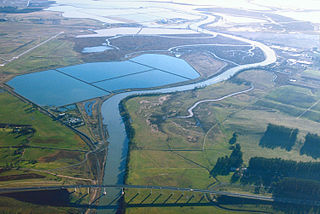
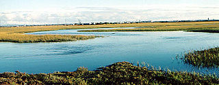
The Napa Sonoma Marsh is a wetland at the northern edge of San Pablo Bay, which is a northern arm of the San Francisco Bay in California, United States. This marsh has an area of 48,000 acres (194 km2), of which 13,000 acres (53 km2) are abandoned salt evaporation ponds. The United States Government has designated 13,000 acres (53 km2) in the Napa Sonoma Marsh as the San Pablo Bay National Wildlife Refuge.
The Seal Beach National Wildlife Refuge is a wildlife refuge encompassing 965 acres (3.91 km2) located in the California coastal community of Seal Beach. Although it is located in Orange County it is included as part of the San Diego National Wildlife Refuge Complex. It was established in 1972.

Tolay Lake is a shallow freshwater lake in southern Sonoma County, California, United States. The lake, nestled within the southern vestiges of the Sonoma Mountains, is the site of significant Native American prehistoric seasonal settlement. In 2005, Sonoma County acquired the entirety of the lake and virtually its whole drainage basin from the Cardoza family for the sum of $18 million; the county's intention is to utilize the property as Tolay Lake Regional Park for ecological and archaeological preservation, as well as public use and enjoyment. Tolay Lake and its immediate drainage area is home to several nesting pairs of golden eagles, Aquila chrysaetos, and a number of rare, threatened or endangered species including the California red-legged frog, Rana draytonii; Western pond turtle, Actinemys marmorata; and Western burrowing owl, Athene cunicularia.

The Loch Lomond Vernal Pool Ecological Reserve is a nature reserve of 8.22 acres (33,300 m2) in the community of Loch Lomond in Lake County, California. It is one of 119 ecological reserves managed by the California Department of Fish and Game (CDFG). The ecological reserve system was authorized by the state legislature in 1968 for the purpose of conservation and protection of rare plants, animals and habitats.
Wingo is a ghost town located in Sonoma County, California in the United States. It can be found on older maps as a dot along the sloughs of Sonoma Creek, south of Sonoma and Schellville, and west of Buchli.

The San Francisco Bay Salt Ponds are a roughly 16,500-acre (6,700 ha) part of the San Francisco Bay that have been used as salt evaporation ponds since the California Gold Rush era. Most of the ponds were once wetlands in the cities of Redwood City, Newark, and Hayward, and other parts of the bay.

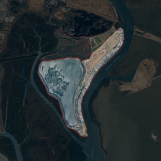
Bull Island is an island in the Napa River, in Napa County, California. From the 1880s onward, it was owned by the Money family, who constructed levees and reclaimed the land, using it to farm grain and potatoes. It was described as a "fine ranch" in 1918. After a levee failure in 1954, it gradually eroded into the water, becoming a salt marsh; for some time afterward, it was used as an evaporation pond for the industrial production of salt by the Leslie Salt Company. Beginning in the 1970s, Bull Island was proposed for inclusion in a variety of riparian preservation projects, but none came to fruition. However, in 1997, the Money family sold it to the California State Lands Commission, who turned it into a wildlife habitat; today it is administered as part of the Fagan Marsh Ecological Reserve, and hosts animals of numerous endangered species.

Little Island is a partially submerged marsh island in the Napa Slough, branching off from the Napa River upstream of San Pablo Bay. It is almost entirely in Napa County, California, although part of its southern tip is in Solano County; it is managed as part of the Napa-Sonoma Marshes Wildlife Area. Its coordinates are 38°10′48″N122°21′05″W, and the United States Geological Survey measured its elevation as 3 ft (0.91 m) in 1981.

Coon Island is an island in the Napa River, upstream of San Pablo Bay. It is in Napa County, California, and managed as part of the Napa-Sonoma Marshes Wildlife Area. Its coordinates are 38°11′33″N122°19′24″W, and the United States Geological Survey measured its elevation as 3 ft (0.91 m) in 1981.
Edgerly Island is an island in the Napa River, upstream of San Pablo Bay. It is in Napa County, California, and managed as part of the Napa-Sonoma Marshes Wildlife Area. Its coordinates are 38°12′12″N122°18′52″W, and the United States Geological Survey measured its elevation as 3 ft (0.91 m) in 1981.

Green Island is an island in the Napa River, upstream of San Pablo Bay. It is in Napa County, California, and managed as part of the Napa-Sonoma Marshes Wildlife Area. Its coordinates are 38°12′09″N122°18′16″W, and the United States Geological Survey measured its elevation as 23 ft (7.0 m) in 1981. It, long with Island No. 1, Island No. 2 and Tubbs Island, are labeled on a 1902 USGS map of the area.

Island No. 1 is a partially submerged island in the Napa River, upstream of San Pablo Bay. It is in Napa and Solano County, California, and parts of it are managed as part of the Napa-Sonoma Marshes Wildlife Area. Its coordinates are 38°08′35″N122°20′40″W, and the United States Geological Survey measured its elevation as 3 ft (0.91 m) in 1981. It, along with Island No. 2, Green Island and Tubbs Island, are labeled on a 1902 USGS map of the area.

Island No. 2 is a mostly-submerged island in Solano County, California. Formerly swampland, it was reclaimed into productive farmland, and became the subject of lengthy legal disputes in the early 20th century. Since then, it has become again submerged, and is now part of the Napa-Sonoma Marshes Wildlife Area.

Knight Island is a mostly-submerged island in the Napa River, upstream of San Pablo Bay. It is in Solano County, California, and managed as part of the Napa-Sonoma Marshes Wildlife Area. Its coordinates are 38°08′09″N122°17′58″W, and the United States Geological Survey measured its elevation as 3 ft (0.91 m) in 1981.

Russ Island is a mostly-submerged island in the Napa River, in Napa and Solano Counties, California. It was reclaimed in the late 19th century, and spent many years as productive farmland; in the 1950s, however, it was purchased by the Leslie Salt Company, and deliberately submerged to serve as an evaporation pond for salt production. The company allowed parts of it to be used for duck hunting. By the 1990s, it was acquired by the California Department of Fish and Game, who turned it into a wildlife preserve, and allowed it to return to marshland; it is now managed as part of the Napa-Sonoma Marshes Wildlife Area, and is open to hunting, fishing, birdwatching, photography and hiking activities.

Tubbs Island is an island in San Pablo Bay. It is in Sonoma County, California, and parts of it are managed as part of the Napa-Sonoma Marshes Wildlife Area. Its coordinates are 38°08′59″N122°25′27″W, and the United States Geological Survey measured its elevation as 0 ft (0 m) in 1981. It, long with Island No. 1, Island No. 2 and Green Island, are labeled on a 1902 USGS map of the area.


