Aulds Cove

Last updated
Rock Quarry at Aulds Cove Rock Quarry Auld's cove.jpg
Rock Quarry at Aulds Cove

Canada Nova Scotia location map 2.svg
Red pog.svg
Aulds Cove in Nova Scotia
Porcupine Mountain rock quarry, Aulds Cove Cape breton island 3.jpg
Porcupine Mountain rock quarry, Aulds Cove

Aulds Cove is a community in the Canadian province of Nova Scotia, located in both Antigonish County and Guysborough County. [1]

Situated on the western shore of the Strait of Canso, Aulds Cove is bifurcated by the county line. The northern section of the community is located in Antigonish County and the southern section is located in Guysborough County. Aulds Cove is directly opposite the community of Port Hastings located on Cape Breton Island. The community is thought to have derived its name from Alexander Auld, an early settler who had grist and saw mills at this location. [2]

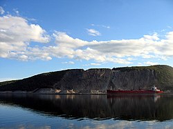
In 1955, the Canso Causeway opened, connecting the southern part of Aulds Cove with Port Hastings by road and railway. As part of this project, new alignments of Nova Scotia Trunk 4 and the Canadian National Railway (CNR) were built through the community. A large quarry on Cape Porcupine Mountain was also built at the southern end of Aulds Cove to supply fill material for the causeway; as of 2015, this quarry continues to operate in its sixth decade.

In the 1960s, the section of Trunk 4 through the community was upgraded as part of the Trans-Canada Highway project and re-designated Nova Scotia Highway 104. Several motels, gas stations, and restaurants have opened in the last few decades and today Aulds Cove primarily serves as a service centre for motorists on Highway 104.

Related Research Articles

Canso Causeway

The Canso Causeway is a 1,385 m (4,544 ft) rock-fill causeway in Nova Scotia, Canada.

Havre Boucher Unincorporated community in Nova Scotia, Canada

Havre Boucher is a community in Antigonish County, Nova Scotia, Canada.

Canso, Nova Scotia Community in Nova Scotia, Canada

Canso is a community in Guysborough County, on the north-eastern tip of mainland Nova Scotia, Canada, next to Chedabucto Bay. In January 2012, it ceased to be a separate town and as of July 2012 was amalgamated into the Municipality of the District of Guysborough.

Canso Canal

The Canso Canal is a short canal located in Nova Scotia, Canada.

Highway 104 in Nova Scotia, Canada, runs from Fort Lawrence at the New Brunswick border near Amherst to River Tillard near St. Peter's. Except for the portion on Cape Breton Island between Port Hawkesbury and St. Peter's, it forms the main route of the Trans-Canada Highway across the province.

The Eastern Shore is a region of the Canadian province of Nova Scotia. It is the Atlantic coast running northeast from Halifax Harbour to the eastern end of the peninsula at the Strait of Canso.

Nova Scotia Trunk 7 is part of the Canadian province of Nova Scotia's system of Trunk Highways. The route runs from Bedford to Antigonish, along the Eastern Shore for a distance of 269 kilometres (167 mi). Part of Trunk 7 is known as the Marine Drive.

Mulgrave, Nova Scotia Town in Nova Scotia, Canada

Mulgrave is a town on the Strait of Canso in Guysborough County, Nova Scotia, Canada. Located along the Marine Drive, Route 344 traverses the community. The town's current name was adopted in 1859 to honour the colonial Lieutenant Governor, the Earl of Mulgrave. Lying opposite to the town of Port Hawkesbury, the community is located along the western shore of the Canso Strait. It was established as McNair's Cove in the early 19th century, and the name Port Mulgrave was adopted in 1859, later shortening to its current form. The early industry of the community relied on ferry service between the Nova Scotia mainland and Cape Breton Island. Ferry service began in the 1810s and rail service reached the area in the 1880s. The ferry services lasted until the opening of the Canso Causeway in 1955, dealing a major blow to the local economy. As of 2016, Mulgrave has a population of 722 and a population density of 40.5/km2 (104.9/sq mi), within an area of 17.83 km2 (6.88 sq mi).

Trunk 4 is part of the Canadian province of Nova Scotia's system of Trunk Highways. The route runs from Highway 104 exit 7 near Thomson Station to Glace Bay. Until the construction of the Trans-Canada Highway, Trunk 4 was a major traffic link in northern Nova Scotia and Cape Breton, and is still used on Cape Breton as an alternative to Highway 105. The highway was originally called the King's Highway, however, this name is no longer applied to the entire road. The only remaining historic section of the highway that maintains the name "King" is King's Road in Sydney.

Trunk 19 is part of the Canadian province of Nova Scotia's system of trunk highways. The road runs from Port Hastings to a junction with the Cabot Trail at Margaree Forks on Cape Breton Island, a distance of 107 kilometres (66 mi). Most of the route is known as the Ceilidh Trail.

The Marine Drive is a designated scenic route along Nova Scotia's Eastern Shore. It closely follows the coast of the Atlantic Ocean and the Strait of Canso from the Canso Causeway to the junction of Route 322 and Highway 111 in Dartmouth.

Sunrise Trail

The Sunrise Trail is a scenic roadway in the Canadian province of Nova Scotia. It is located along the province's North Shore on the Northumberland Strait for 333 km (207 mi) from Amherst to the Canso Causeway.

Nova Scotia Route 316

Route 316 is a collector road in the Canadian province of Nova Scotia. It is located in Antigonish County and Guysborough County, connecting Lower South River at Highway 104 with Half Island Cove at Trunk 16.

Route 344 is a collector road in the Canadian province of Nova Scotia.

Point Tupper is a rural community located in Richmond County, Nova Scotia on the Strait of Canso in western Cape Breton Island.

Port Hastings, Nova Scotia

Port Hastings is a unincorporated settlement on Cape Breton Island, within the Municipality of the County of Inverness, Canada. The population in 2016 was 89.

Canso Canal Bridge Bridge in Canada

The Canso Canal Bridge is a rotating swing bridge in Nova Scotia, Canada. It crosses the Canso Canal at the eastern end of the Canso Causeway, connecting the Nova Scotia peninsula to Cape Breton Island. The bridge carries the 2 traffic lanes of Highway 104 as well as a single track railway line operated by the Cape Breton and Central Nova Scotia Railway (CBNS).

Melford International Terminal is a proposed Canadian marine-rail container terminal to be built in the community of Middle Melford in Guysborough County, Nova Scotia.

St. Georges Bay (Nova Scotia)

St. George's Bay is a bay with shore on the Nova Scotia peninsula and Cape Breton Island, Canada, thus comprising a sub-basin of the Gulf of St. Lawrence.

References

  1. "Aulds Cove". Geographical Names Data Base . Natural Resources Canada . Retrieved 16 March 2018.
  2. Fergusson, C. Bruce (1967). Place-Names and Places of Nova Scotia. Halifax, NS: Public Archives of Nova Scotia. p. 24. Retrieved 16 March 2018.

Coordinates: 45°38′55.85″N61°26′25.27″W / 45.6488472°N 61.4403528°W / 45.6488472; -61.4403528 (Auld's Cove, Nova Scotia)