
Skodje is a former municipality in Møre og Romsdal county, Norway. It was part of the Sunnmøre region. The administrative centre was the village of Skodje. The other main village in the municipality was Valle.

Haram is a former municipality in Møre og Romsdal county, Norway. It was part of the Sunnmøre region. The administrative center was Brattvåg, the industrial center of Sunnmøre. Other important villages in the municipality included Austnes, Eidsvik, Helle, Longva, Hildrestranda, Søvik, Tennfjord, and Vatne.

Midsund is a former municipality in Møre og Romsdal county, Norway. It was part of the Romsdal region. The administrative centre was the village of Midsund on Otrøya island. Other settlements on the island included Uglvik and Raknes in the north and Nord-Heggdal in the southeast.

Sandøy is a former municipality in Møre og Romsdal county, Norway. It was part of the Romsdal region. The administrative centre was the village of Steinshamn. Other villages included Ona and Myklebost. The municipality was spread out over many islands in the mouth of the vast Romsdal Fjord. The Flatflesa Lighthouse and Ona Lighthouse protect the boats traveling around the municipality. The Nordøy Fixed Link project was constructed from 2018 until 2023 and it includes three undersea tunnels and several bridges that will connect the main islands of Sandøy Municipality and the islands of Haram Municipality to the mainland.
Brattvåg is a village in Ålesund Municipality in Møre og Romsdal county, Norway. The village is located on the Norwegian mainland, along the west side of the Samfjorden. It is located about 12.5 kilometres (7.8 mi) northwest of the villages of Vatne/Eidsvik.
Søvik is a village and a regional service center in Ålesund Municipality in Møre og Romsdal county, Norway. It is located in the northwestern part of Ålesund Municipality, along the sea, just southeast of the islands of Bjørnøya and Terøya. The area was part of the municipality of Borgund until 1965 and then it was part of Haram Municipality until 2020 when it joined Ålesund.

Roald is a village in Giske Municipality in Møre og Romsdal county, Norway. The village is located on the northern part of the island Vigra. Roald is located about 20 kilometres (12 mi) north of the city centre of Ålesund. It's connected to the mainland via two undersea tunnels which opened in 1987. Ålesund Airport, Vigra is located 2 kilometres (1.2 mi) south of the village of Roald. Vigra Church is also located a short distance south of Roald.

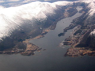
Longva is a village in Ålesund Municipality in Møre og Romsdal county, Norway. The village is located on the southwest side of the island of Skuløya, along the Longvafjorden. It is about 12 kilometres (7.5 mi) northeast of the village of Austnes on Haramsøya via the Ullasund Bridge. The population (2003) was 637, but since 2004, Longva has not been considered an urban settlement by Statistics Norway, and its data is therefore not registered.

Hollingen is a village in Møre og Romsdal county, Norway. The village is mostly in Aukra Municipality, but about 1/3rd of the village area lies to the north of the municipal border inside Hustadvika Municipality. It is located on the Romsdal peninsula along the Julsundet strait about 15 kilometres (9.3 mi) northwest of the city of Molde. The village is mostly located on the small part of Aukra that is located on the mainland. The village has ferry service across the Julsundet strait to the village of Aukrasanden on Gossa.

Møre og RomsdalUrban East Norwegian: [ˈmø̂ːrə ɔ ˈrʊ̀msdɑːl](listen) is a county in the northernmost part of Western Norway. It borders the counties of Trøndelag, Innlandet, and Vestland. The county administration is located in the town of Molde, while Ålesund is the largest town. The county is governed by the Møre og Romsdal County Municipality which includes an elected county council and a county mayor. The national government is represented by the county governor.

Lepsøya is a populated island in Ålesund Municipality in Møre og Romsdal county, Norway. The 12.1-square-kilometre (4.7 sq mi) island in the northern part of the municipality. It is located in the ocean in the northwestern part of the municipality, with the Haramsfjorden and the island of Haramsøya to the northeast; the Vigrafjorden and the island of Vigra to the southwest; and the islands of Bjørnøya and Terøya along with the mainland to the southeast.

Haramsøya is an island in Ålesund Municipality in Møre og Romsdal county, Norway. The island is located between the islands of Lepsøya and Flemsøya, just 4 kilometres (2.5 mi) northwest of the mainland. The village of Austnes is located on the southeast part of the island, and that is the location of Haram Church. The Ulla lighthouse is located on the north end of the island. The population (2015) of the island is 571.

Flemsøya or Skuløya is an island in Ålesund Municipality in Møre og Romsdal county, Norway. The 14.3-square-kilometre (5.5 sq mi) island is located between the islands of Haramsøya and Fjørtofta. The island is connected to the neighboring island of Haramsøya by the Ullasund Bridge. The population (2015) of the island was 503. The eastern and southern coastline is flat, the rest of the island is mountainous. The highest point, Skulen, is 492 metres (1,614 ft) tall. The village of Longva is located on the west side of the island, along the Longvafjorden.

Fjørtofta is an island in Ålesund Municipality in Møre og Romsdal county, Norway. The 8.9-square-kilometre (3.4 sq mi) island is located in the northern part of the municipality, between the islands of Flemsøya, Harøya, and Midøya and Dryna.

Myklebost or Myklebust is a village on the southern end of the island of Harøya in Ålesund Municipality in Møre og Romsdal county, Norway. The village is about 7 kilometres (4.3 mi) south of the municipal center of Steinshamn. There are ferry connections from Myklebost to Fjørtofta and Brattvåg in Haram Municipality and to Dryna in Midsund Municipality. The Myklebost area was a part of Haram Municipality until 1965. Harøy Church is located about 5 kilometres (3.1 mi) north of the village.
Harøya is a swampy island in Ålesund Municipality in Møre og Romsdal county, Norway. At 13.6 square kilometres (5.3 sq mi), it is the largest island in the municipality. The island is located between the islands of Finnøya and Fjørtofta.
Årset is a village in Ålesund Municipality in Møre og Romsdal county, Norway. The village is located along the Ellingsøyfjorden on the southern shore of the island of Ellingsøya, about 4 kilometres (2.5 mi) east of the village of Myklebost and about 12 kilometres (7.5 mi) west of the village of Tennfjord in Haram Municipality.

Aure is the administrative centre of Aure Municipality in Møre og Romsdal county, Norway. The village is located on the mainland, along the Aursundet strait.

Midsund is a village in Molde Municipality in Møre og Romsdal county, Norway. The village is located on the western end of the island of Otrøya. The eastern end of the Midsund Bridge is located in the village of Midsund, connecting it to the neighboring island of Midøya to the west.

Vigra is an island in Giske Municipality in Møre og Romsdal county, Norway. The 20-square-kilometre (7.7 sq mi) island is located north of the islands of Valderøya and Giske, west of the mainland of Haram Municipality, and southwest of the island of Lepsøya. Vigra has a road connection to the mainland via the Vigra Fixed Link, a series of tunnels and bridges that connect all the islands of Giske Municipality to the city of Ålesund to the south. The island was formerly part of Vigra Municipality.


