Austro-Hungarian fortifications on the Italian border

Last updated
Fortifications along the Italy - Austria-Hungary border in 1915. Fortified towns in red. Red line: Austrian front line, green line: Italian front line Settore Dolomitico1.JPG
Fortifications along the Italy - Austria-Hungary border in 1915. Fortified towns in red. Red line: Austrian front line, green line: Italian front line

The Austro-Hungarian fortifications on the Italian border were constructed in the 19th and early 20th centuries to protect against invasion from Italy. Most were built in what is today the Trentino-Alto Adige region; some built outside this territory were ceded to Italy after 1866. By the First World War many of them were obsolete, but nevertheless played a role in deterring and containing Italian assaults. [1] [2]

Contents

Terminology

Generally, in Austrian military terminology these defensive structures were not referred to as forts. The terms used to describe them were werk ('works'), sperre ('barrier') or straßensperre ('roadblock'). Defence districts were referred to as 'rayons'. Originally there were only two, divided into subrayons or sections. Over the course of the First World War, however, more and more subrayons and sections were replaced by rayons.

Construction

Before 1866

Before the Second Italian War of Independence the main Austrian fortifications in Italy were the Quadrilatero in the Po valley. [3] In addition to these strongpoints the Franzensfeste Fortress (1833-1838) was built to guard the southern approaches to the Brenner Pass [4] and the Nauders road barrier (1838–40) to guard the Reschen Pass. [5] [6] Doss Trento was also fortified from 1848 to 1859. [7]

After 1859, the most important passes along the new border with Italy between Lake Garda and Switzerland were fortified, as was Riva del Garda and the road to Trento. These fortifications mostly consisted of large multi-storey structures of natural stone, with cannon mounted behind embrasures. The introduction of rifled firearms soon rendered their design obsolete, but they provided shelter for the guns, which was important in a mountain environment. It was also assumed that the Italians would not try to manoeuvre heavy artillery up into the mountains to threaten these installations. Among the structures dating from this period were de:Forte Ceraino, de:Forte Rivoli and de:Forte Monte, but these were built in territory that passed to Italy in 1866. [8] [9]

1866-1900

Fort Hensel, 1915 Fort Hensel. Reproduktion aus der L'illustratione Italiano. vom 28. November 1915. (BildID 15465824).jpg
Fort Hensel, 1915

After the Third Italian War of Independence Austria also fortified the new eastern border with the Veneto. From 1870 to 1873 a group of defensive works was erected at Civezzano to block the route to Trento from the Brenta valley. From 1878 to 1883 the defences of Trento itself were expanded in what became known as the Trientiner style, using a light and economical construction method, with most guns placed in open batteries. A Gruson gun turret was built at the San Rocco works. [10] [11] Defences were also upgraded at Fort Hensel, built between 1881 and 1890, which blocked the it:Val Canale near Malborgeth on the southern border of Carinthia [12] [13] and the Kluže Fortress further east in present-day Slovenia.

Archduke Leopold Salvator inspecting the Corno works Erzherzog Leopold Salvator inspiziert das Werk Corno (BildID 15520065).jpg
Archduke Leopold Salvator inspecting the Corno works
Werk Corno 1914 Werk Corno 1914.jpg
Werk Corno 1914

From 1884 onwards, many new defences were built according to a relatively uniform scheme overseen by Field Marshal Julius Ritter von Vogl. [14] In particular, the passes in the Dolomites and the Brenta were fortified for the first time, as was the Predil Pass in modern Slovenia. Lardaro was reinforced with the new Corno works; [15] the defences of Trento were expanded with the Romagnano and Mattarello works [16] and the Riva fortress was reinforced with the new batteria di mezzo. [17] The Vogl works were compact integrated structures combining armament and accommodation in a single block. They were mostly built of concrete, with the front clad with granite blocks. The armament consisted of mostly three or four 12-cm cannons behind armoured embrasures, and two to four 15-cm mortars in armored rotating domes on the roof. [18] The works were surrounded by a ditch that could be swept by fire from several caponiers. For close defense, 11 mm mitrailleuses were initially used and machine guns installed from 1893. Because of their embrasures and being built several stories high they had a marked elevation above ground.

1900-1915

Werk Tonale, Presanella Beim Werk Tonale, Verteidigung Presanella. (BildID 15515232).jpg
Werk Tonale, Presanella

In the years before the First World War, the Riva fortress was strengthened with the Garda and Tombio works and Ladaro with the Carriola work. The Tonale Pass, previously fortified with only one old works, was expanded into a cluster of fortifications with five works of different sizes while Folgaria and Lavarone southeast of Trento were also expanded and strengthened. [19]

Developments in the technology of artillery led to new design parameters for fortifications, able to withstand increased calibre and penetration of modem shells. Increasingly, structures were built underground. 10-cm howitzers in rotating armored domes were now standard, together with machine guns for replacing both can in embrasures and machine guns close defense. Typical of this design was the works at Valmorbia, unfinished when Italy declared war in May 1915. [20]

Rayon of Tyrol

The Rayon of Tyrol Came under the Tyrol State Defense Command:

Subrayon I

Border section 1 - Stilfserjoch Barrier: Ortler with the Gomagoi (1860–62) roadblock protecting the road from the Stelvio Pass to the Vinschgau and the Reschen Pass and Nauders roadblock (1838-1840) blocking the Inn Valley to the north and the road to Landeck and Vorarlberg. [21]

Subrayon II

Border section 2 - Tonale Barrier: barriers guarding the Tonale Pass. Strino (1860-1862), Tonale (1907–10), Presanella (1910–12) Pejo (1908-1910) and Mero (1905-1910/12). The role of these works was to block the Tonale pass road and to protect the Sulztal (Val di Sole) and the Adige valley, preventing Trento from being cut off from the north. [22] [23]

Subrayon III

Generic diagram of an armoured cannon turret similar to those Austria-Hungary used in its fortifications EB1911 Fortifications - Fig. 56.jpg
Generic diagram of an armoured cannon turret similar to those Austria-Hungary used in its fortifications
Nago roadblock Forte di Nago.jpg
Nago roadblock
Plan of Casara works Mappa forte Casara.JPG
Plan of Casara works

Border section 3 - Lardaro Barrier: south of the Adamello-Presanella group, Larino (1860-1861), Danzolino (1860 to 1862), Corno (1890 to 1894), Revegler (1860-1862) and Carriola (1911-1915). The Lardaro lock secured the Giudicarie to the north and the confluence of the Valdaone to the east. This covered the rear of the Riva fortress and the flank of Trento. [24] [25] [26]

Border section 3 - the Riva Fortress securing the roads around Lago d'Ampola and Lago di Ledro to Trento and the Adige Valley. Riva had the following structures:

Blocking group Ponale  [ de ] consisted of:

Border section 4 - The Fortress of Trento and the Adige Barrier (Etschtalsperre), countering threats from the south (Adige Valley) and southeast from the Valsugana.

Fortress of Trento major structures:

There were also many smaller works, armored machine-gun positions and concrete infantry strongpoints.

The Val di Non barrier consisted of the large Rocchetta roadblock (1860–64) [27] securing Mezzolombardo (Welschmetz) in the Non Valley against the Val di Sole if a breakthrough over the Tonale Pass succeeded.

The Adige-Arsa Barrier consisted only of the unfinished Valmorbia works (1912-1915, also referred to as "Forte Pozzacchio") in Vallarsa. Further projects (Mattassone/Coni Zugna/Pasubio/Cornale and Vignola) did not get beyond the planning phase. [28]

Border section 5 - Folgaria/Lavarone/Sette Comuni built between 1907 and 1913 and among the most modern fortresses in Austria-Hungary. It was in front of the line of the older works (Tenna, Colle delle benne, Mattarello and Romagnano) from the Vogl construction period.

Lavarone Group (Lafraun):

Plan showing the cover of fire from Gschwent Plan Werk Gschwendt.png
Plan showing the cover of fire from Gschwent
Plan showing cover of fire from Lusern Plan Werk Lusern.png
Plan showing cover of fire from Lusern

Folgaria Group (Vielgereuth):

Border section 6 - Valsugana - external works at Caldonazzo and Levico:

Subrayon IV

Border section 7 - Kreuzberg Pass to Lusia Pass (Fiemme Valley)

Border section 8 - Lusia Pass to Monte Mesola. The Rolle Pass barrier consisted of the Paneveggio barrier, Dossaccio (1889-1892, 1912) and Albuso (1889-1892, 1912) blocking the Rolle Pass, the Travognolo Valley and the route from Fassa to the Fiemme Valley. Further back in the Pellegrino valley was the Moena barrier (1897-1899).

Subrayon V

Border section 9 - Monte Mesola to Gottrestal.

The Buchensteintal Barrier consisted only of the la Corte (1897-1900) and the Ruaz road barrier (1897-1900). They blocked the way from Alleghe to Canazei and the Pordoi Pass to Corvara.

Valparola Pass Barrier The Tre Sassi barrage (1897-1900) blocked access to the Val Badia.

Ampezzo Blocking Group consisting of Plätzwiese (1889-1894) securing the Stolla Valley and the Höhlensteintal as well as the Landro (1884-1892), securing the road from Cortina d'Ampezzo to Toblach and the Puster Valley. [29] [30]

Border section 10 - Gottrestal to the Carinthian border wth the Sexten Barrier. Haideck (1884-1889) and Mitterberg (1884-1889) secured Sexten and the Kreuzberg Saddle. [31] [32]

Rayon of Carinthia

In the Rayon of Carinthia, the subrayons were called sections. In 1915 he was under the command of Franz Rohr von Denta. The border from Krn to the Mediterranean Sea was not fortified and therefore not included in this scheme.

Section I

Kreuzberg Pass - Plöcken Pass - Stranigerspitze/Monte Cordin

Section II

Straningerspitze/Monte Cordin - Naßfeld Pass - Shinouz/it:Monte Scinauz

The Malborgeth Barrier consisted only of Fort Hensel "A" (1881-1884) and "B" (1881 to 1890) near the village of Malborgeth in the Canale Valley. They blocked the road from Pontafel to Tarvis and Villach in Carinthia. "Fort Hensel" was not referred to as a work, but as a fort because it was named after a person and not, as was more common, after a location. It was named after Captain it:Friedrich Hensel, who fell here in 1809 in the war against Napoleon. [33]

Section III

Flitscher Klause Flitscher Klause mit Kleinem Svinjak. (BildID 15736989).jpg
Flitscher Klause

Shinouz/it:Monte Scinauz- Predil Pass - Rombon

In the Seebachtal, the Predil / Battery Predilsattel (1897 to 1899) and Raibl (1885 to 1887, also called Seewerk Raibl, Raiblsee or Seebachtalsperre bei Raibl ) works blocked access through the Seebachtal and the Predilpass to Carinthia. Shortly after the factory directly on the Predilpass, there was also the Oberbreth / Predil depot (1850) on the Krainer side.

Section IV

Rombon - Krn

Fort Hermann (1897-1900) and Flitscher Klause (1880-1882) above Bovec (Flitsch) (in modern Slovenia) prevented a breakthrough into Austria from the Isonzo valley via the Predil Pass. Unusually "Fort Hermann" was not referred to as a works but as a fort. It was named after captain de:Johann Hermann von Hermannsdorf, who fell here in 1809 in the war against Napoleon. [34] [35] [36]

See also

Related Research Articles

<span class="mw-page-title-main">Fortification</span> Military defensive construction

A fortification is a military construction designed for the defense of territories in warfare, and is used to establish rule in a region during peacetime. The term is derived from Latin fortis ("strong") and facere.

<span class="mw-page-title-main">Reschen Pass</span> Mountain pass of the Alps between South Tyrol, Italy and Tyrol, Austria

Reschen Pass is a mountain pass across the main chain of the Alps, connecting the Upper Inn Valley in the northwest with the Vinschgau region in the southeast. Since 1919, the border between South Tyrol, Italy and Tyrol, Austria has approximately followed the watershed, the pass summit at a height of 1,504 metres (4,934 ft) being completely on Italian territory.

<span class="mw-page-title-main">Val di Sole</span> Valley in Italy

The Sole Valley is a valley in Trentino, northern Italy.

<span class="mw-page-title-main">Malborghetto Valbruna</span> Comune in Friuli Venezia Giulia, Italy

Malborghetto Valbruna is a comune (municipality) in the Regional decentralization entity of Udine in Friuli Venezia Giulia, north-east Italy.

<span class="mw-page-title-main">Predil Pass</span> Mountain pass on border between Italy and Slovenia

The Predil Pass or Predel Pass is a high mountain pass on the border between Italy and Slovenia.

<span class="mw-page-title-main">Nauders</span> Place in Tyrol, Austria

Nauders is a municipality in the district of Landeck in the Austrian state of Tyrol.

<span class="mw-page-title-main">Alpine Wall</span> Italian defensive fortifications

The Alpine Wall was an Italian system of fortifications along the 1,851 km (1,150 mi) of Italy's northern frontier. Built in the years leading up to World War II at the direction of Italian dictator Benito Mussolini, the defensive line faced France, Switzerland, Austria, and Yugoslavia. It was defended by the "Guardia alla Frontiera" (GaF), Italian special troops.

<span class="mw-page-title-main">Lake Predil</span> Lake in Italy

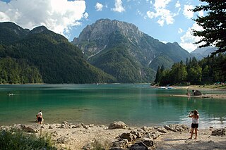
Lake Predil is a lake near Cave del Predil, part of the Tarvisio municipality in the Province of Udine, in the Italian region of Friuli Venezia Giulia.

<span class="mw-page-title-main">Fortified Sector of the Dauphiné</span>

The Fortified Sector of the Dauphiné was the French military organization that in 1940 controlled the section of the Alpine Line portion of the Maginot Line facing Italy in the vicinity of Briançon. By comparison with the integrated defenses of the main Maginot Line, or even of the Fortified Sector of the Maritime Alps to the south, the Dauphiné sector consisted of a series of distinct territories that covered two main invasion routes into France: the route from Turin over the Col de Montgenèvre to Briançon and Grenoble, and the route from Coni over the Col de Larche to Barcelonette and Gap. The sector was the scene of probing attacks by Italian forces during the Italian invasion of France in 1940, in which the French defenses successfully resisted Italian advances until the June 1940 armistice that granted Italy access to southeastern France.

<span class="mw-page-title-main">Battle of Tarvis (1809)</span> 1809 battle during the War of the Fifth Coalition

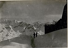
The Battle of Tarvis from 16 to 17 May 1809, the Storming of the Malborghetto Blockhouse from 15 to 17 May 1809, and the Storming of the Predil Blockhouse from 15 to 18 May saw the Franco-Italian army of Eugène de Beauharnais attacking Austrian Empire forces under Albert Gyulai. Eugène crushed Gyulai's division in a pitched battle near Tarvisio, then an Austrian town known as Tarvis. At nearby Malborghetto Valbruna and Predil Pass, small garrisons of Grenz infantry heroically defended two forts before being overwhelmed by sheer numbers. The Franco-Italian capture of the key mountain passes allowed their forces to invade Austrian Kärnten during the War of the Fifth Coalition. Tarvisio is located in far northeast Italy, near the borders of both Austria and Slovenia.

<span class="mw-page-title-main">Fortress Saint-Maurice</span>

Fortress Saint-Maurice is one of the three main fortification complexes comprising the Swiss National Redoubt. The westernmost of the three, Fortress Saint-Maurice complements Fortress Saint Gotthard and Fortress Sargans to secure the central alpine region of Switzerland against an invading force. The National Redoubt was first conceived in the 1880s as an easily defensible area to secure the survival of the Swiss Confederation. In the late 1930s and 1940s when neutral Switzerland was threatened with invasion from Germany, the National Redoubt and its components were modernized and expanded on a massive scale. The fortification system was maintained and upgraded during the Cold War. With the collapse of the Soviet Union, the possibility of a Warsaw Pact invasion disappeared, and by 1995 many positions were abandoned by the military.

<span class="mw-page-title-main">National Redoubt (Switzerland)</span> Defensive plan developed by the Swiss government

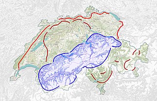
The Swiss National Redoubt is a defensive plan developed by the Swiss government beginning in the 1880s to respond to foreign invasion. In the opening years of the Second World War the plan was expanded and refined to deal with a potential German invasion. The term "National Redoubt" primarily refers to the fortifications begun in the 1880s that secured the mountainous central part of Switzerland, providing a defended refuge for a retreating Swiss Army.

The Infanterie-Werk Belle-Croix, renamed Fort Lauvallière after 1919, is a military installation near Metz. It is part of the second fortified belt of forts of Metz.

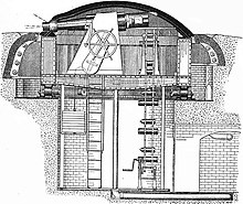
The forts of Metz are two fortified belts around the city of Metz in Lorraine. Built according to the design and theory of Raymond Adolphe Séré de Rivières at the end of the Second Empire—and later Hans von Biehler while Metz was under German control—they earned the city the reputation of premier stronghold of the German reich. These fortifications were particularly thorough given the city's strategic position between France and Germany. The detached forts and fortified groups of the Metz area were spared in World War I, but showed their full defensive potential in the Battle of Metz at the end of World War II.

<span class="mw-page-title-main">Fortified Sector of Savoy</span>

The Fortified Section of Savoy(Secteur fortifié de la Savoie) was the French military organization that in 1940 controlled the section of the Alpine Line portion of the Maginot Line facing Italy in the Savoy region. The sector constituted part of the Alpine Line portion of the Maginot Line, between the Defensive Sector of the Rhône to the north, and the Fortified Sector of the Dauphiné to the south. The works combined a number of pre-1914 fortifications with Maginot-style ouvrages, with many forward-positioned cavern-style frontier stations or avant-postes that proved effective in holding invading forces near the order.

<span class="mw-page-title-main">White War</span> High-altitude mountain warfare in the Italian front of World War I

The White War is the name given to the fighting in the high-altitude Alpine sector of the Italian front during the First World War, principally in the Dolomites, the Ortles-Cevedale Alps and the Adamello-Presanella Alps. More than two-thirds of this conflict zone lies at an altitude above 2,000m, rising to 3905m at Mount Ortler. In 1917 New York World correspondent E. Alexander Powell wrote: “On no front, not on the sun-scorched plains of Mesopotamia, nor in the frozen Mazurian marshes, nor in the blood-soaked mud of Flanders, does the fighting man lead so arduous an existence as up here on the roof of the world.”

The Cadorna Line, officially the Northern Frontier, was the Italian defensive system on the northern border facing Switzerland, designed and built between 1899 and 1918. Its purpose was to protect the Po Valley and its main industrial centres from an attack by France, Germany or Austria-Hungary violating Swiss neutrality.

<span class="mw-page-title-main">Italian fortifications on the Austro-Hungarian border</span>

Between the 1860s and the First World War the Kingdom of Italy built a number of fortifications along its border with Austria-Hungary. From 1859 the fortified border ran south from Switzerland to Lake Garda, between Italian Lombardy and Austrian South Tyrol. After 1866 it extended to include the border between South Tyrol and Veneto, from Lake Garda to the Carnic Alps. This frontier was difficult to defend, since Austria-Hungary held the higher ground, and an invasion would immediately threaten the industrial and agricultural heartlands of the Po valley. Between 1900 and 1910, Italy also built a series of fortifications along the defensive line of the Tagliamento to protect against an invasion from the northeast. The border with Switzerland was also fortified in what is known as the Cadorna Line.

<span class="mw-page-title-main">Operations in Valtellina (1866)</span> Battle of the Third Italian War of Independence

The Operations in Valtellina was a battle of the Third Italian War of Independence and consisted in the penetration of Austrian units of the 8th Division of General Franz Kuhn von Kuhnenfeld operating in Trentino against the Italian Volunteer Corps of Giuseppe Garibaldi and in the subsequent Italian counterattack of the Mobile National Guard commanded by Colonel Enrico Guicciardi.

<span class="mw-page-title-main">Fortress of Trento</span> Fortification in the municipality of Trento, Italy

The Fortress of Trento is the fortified wall built around the city of Trento starting in 1860 and strategically active until its dissolution in 1916.

References

  1. Ivan Bruno Zabeo (2016). Dolesi al fronte. La prima guerra mondiale. Mazzanti Libri - Me Publisher. p. 41. ISBN   978-88-98109-85-2 . Retrieved 14 October 2020.
  2. Alexander Jordan (2008). Krieg um die Alpen: Der Erste Weltkrieg im Alpenraum und der bayerische Grenzschutz in Tirol. Duncker & Humblot. pp. 272–3. ISBN   978-3-428-52843-1 . Retrieved 14 October 2020.
  3. Geoffrey Wawro (1997-09-13). The Austro-Prussian War: Austria's War with Prussia and Italy in 1866. Cambridge University Press. pp. 89–. ISBN   978-0-521-62951-5 . Retrieved 13 October 2020.
  4. "Franzensfeste Fortress". museums-southtyrol.it. Museums of South Tyrol. Retrieved 13 October 2020.
  5. "Festung Nauders". nauders.tirol.gv.at. Gemeinde Nauders. Retrieved 13 October 2020.
  6. Oswald von Gschliesser (1965). Tirol---Österreich: gesammelte Aufsätze zu deren Geschichte. Wagner. p. 133. Retrieved 13 October 2020.
  7. Riccardo Gasperi (1968). Per Trento e Trieste l'amara prova del 1866: Storia politico-militare del 1866, con particolare riguardo alla spedizione Medici nella Valsugana. Comitato provinciale per il cinquantenario dell'unione del Trentino all'Italia. p. 19.
  8. Ferdinand Mayer (1875). Geschichte des k.k. [i.e. kaiserlich-koeniglichen] Infanterie-Regimentes Nr.39. Рипол Классик. p. 548. Retrieved 13 October 2020.
  9. Arthur Janke (1874). Reise-Erinnerungen aus Italien, Griechenland und dem Orient: Mit besonderer Berücksichtigung der militairischen Verhältnisse. Schneider. p. 29. Retrieved 13 October 2020.
  10. "Forte San Rocco a Trento: segnalazione per la Lista Rossa". italianostra.org. Italia Nostra. Archived from the original on 24 February 2019. Retrieved 13 October 2020.
  11. "San Rocco". fortificazione.net. Fortificazione.net. Retrieved 13 October 2020.
  12. Weiss, Ulrike. Il Forte Hensel a Malborghetto 1881-1916. Fortress Books.
  13. "Fort Hensel". kick-fortification. Österreichische Gesellschaft für Festungsforschung. Retrieved 13 October 2020.
  14. Rassegna storica del Risorgimento: organo della Società nazionale per la storia del Risorgimento italiano. S. Lapi. 2008. p. 6. Retrieved 14 October 2020.
  15. "Werk Corno". trentinograndeguerra.it. Museo Storico Italiano della Guerra. Retrieved 13 October 2020.
  16. "Hauptwerk Mattarello". kuk-fortification.net. Österreichische Gesellschaft für Festungsforschung. Retrieved 13 October 2020.
  17. "Mittelbatterie Riva". trentinograndeguerra.it. Museo Storico Italiano della Guerra. Retrieved 13 October 2020.
  18. "15 cm Panzermörser". kuk-fortification.net. Österreichische Gesellschaft für Festungsforschung. Retrieved 13 October 2020.
  19. "Beschreibung der / Description of the Sperre Folgaria – Lavarone". kuk-fortification.net. Österreichische Gesellschaft für Festungsforschung. Retrieved 14 October 2020.
  20. "Werk Valmorbia". kuk-fortification.net. Österreichische Gesellschaft für Festungsforschung. Retrieved 14 October 2020.
  21. Südtiroler Schützenbund (2005). Tirol vor und im 1. Weltkrieg: der Erste Weltkrieg 1914-1918, die Tiroler Front 1915-1918. Arkadia. p. 165. ISBN   978-88-8300-029-4 . Retrieved 15 October 2020.
  22. "On the Paths of the Great War". pontedilegnotonale.it. Consorzio Pontedilegno-Tonale. Retrieved 15 October 2020.
  23. "Saccarana". fortificazione.net. Retrieved 15 October 2020.
  24. Heinz von Lichem (1980). Gebirgskrieg 1915-1918: Ortler, Adamello, Gardasee. Athesia. pp. 297–8. ISBN   978-88-7014-175-7 . Retrieved 15 October 2020.
  25. "Werk Danzolino". kuk-fortification.net. Österreichische Gesellschaft für Festungsforschung. Retrieved 16 October 2020.
  26. "Straßensperre Revegler". kuk-fortification.net. Österreichische Gesellschaft für Festungsforschung. Retrieved 16 October 2020.
  27. Marco Milanese (2020-07-31). APM – Archeologia Postmedievale, 22, 2018. L'archeologia della Prima Guerra Mondiale. Scenari, progetti, ricerche / The archaeology of the First World War. Research background, projects and case studies. All'Insegna del Giglio. pp. 107–. ISBN   978-88-7814-959-5 . Retrieved 13 October 2020.
  28. "Werk Valmorbia". kuk-fortification.net. Österreichische Gesellschaft für Festungsforschung. Retrieved 16 October 2020.
  29. "Werk Plätzwiese". kuk-fortification.net. Retrieved 16 October 2020.
  30. "Werk Landro". kuk-fortification.net. Österreichische Gesellschaft für Festungsforschung. Retrieved 16 October 2020.
  31. "Werk Haideck". kuk-fortification.net. Österreichische Gesellschaft für Festungsforschung. Retrieved 16 October 2020.
  32. "Werk Mitterberg". kuk-fortification.net. Österreichische Gesellschaft für Festungsforschung. Retrieved 16 October 2020.
  33. "Fort Hensel". kuk-fortification.net. Österreichische Gesellschaft für Festungsforschung. Retrieved 16 October 2020.
  34. Jahrbuch der Kaiserlich-Koniglichen Geologischen Reichsanstalt. Aus der K. K. Hof-und Staats-Druckerei. 1858. p. 357. Retrieved 16 October 2020.
  35. Franz Bersin (1875). Laibacher Schulzeitung. Organ des krainischen Landes-Lehrervereins. Red. Joh(ann) Sima. Kleinmayr & Bamberg. p. 229. Retrieved 16 October 2020.
  36. "Fortification Fort Hermann". potmiru.si. Ustanova »Fundacija Poti miru v Posočju«. Retrieved 16 October 2020.