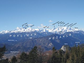
The Julian Alps are a mountain range of the Southern Limestone Alps that stretch from northeastern Italy to Slovenia, where they rise to 2,864 m at Mount Triglav, the highest peak in Slovenia. A large part of the Julian Alps is included in Triglav National Park. The second highest peak of the range, the 2,755 m high Jôf di Montasio, lies in Italy.

A mountain pass is a navigable route through a mountain range or over a ridge. Since mountain ranges can present formidable barriers to travel, passes have played a key role in trade, war, and both human and animal migration throughout history. At lower elevations it may be called a hill pass. A mountain pass is typically formed between two volcanic peaks or created by erosion from water or wind.

Pankow is the second largest area of Berlin by population. In Berlin's 2001 administrative reform, it was merged with the former boroughs of Prenzlauer Berg and Weißensee; the resulting borough retained the name Pankow. Pankow was sometimes claimed by the Western Allies to be the capital of the German Democratic Republic, while the German Democratic Republic itself considered East Berlin to be its capital.

The Simplon Pass is a high mountain pass between the Pennine Alps and the Lepontine Alps in Switzerland. It connects Brig in the canton of Valais with Domodossola in Piedmont (Italy). The pass itself and the villages on each side of it, such as Gondo, are in Switzerland. The Simplon Tunnel was built beneath the vicinity of the pass in the early 20th century to carry rail traffic between the two countries.
Bezirk Spittal an der Drau is an administrative district (Bezirk) in the state of Carinthia, Austria.
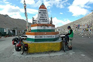
Chang La is a high mountain pass in Ladakh at an elevation of 5,391.3024 m (17,688.000 ft) in the Ladakh Range between Leh and the Shyok River valley. The Chang La, on Leh to Pangong Lake road, lies on the Leh-Karu-Sakti-Zingral-Chang La-Durbuk-Tangtse-Pangong Lake motorable road. Karu, which lies on Leh-Manali NH-3, connects Chang La and Pangong Lake to Leh and the rest of India. In September 2021, BRO opened another alternate motorable asphalt road between Zingral and Tangtse via Ke La pass and Taruk.

Weißensee is a quarter in the borough of Pankow in Berlin, Germany, that takes its name from the small lake Weißer See within it. Before Berlin's 2001 administrative reform, Weißensee was a borough in its own right, consisting of the quarters of Weißensee, Heinersdorf, Blankenburg, Karow, and Stadtrandsiedlung Malchow. A fictional German-language TV series by the same name is set in the borough between 1980 and 1990 during the communist era.
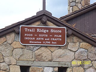
Fall River Pass is a mountain pass in northern Colorado, in the Rocky Mountains of the western United States. It is located in the Front Range, within Rocky Mountain National Park. The pass is traversed by U.S. Highway 34 on Trail Ridge Road between Granby and Estes Park. However, as at Milner Pass on the Continental Divide, the road does not descend after reaching the pass from the west, but instead continues to climb along a side ridge; thus, neither pass is the high point on Trail Ridge Road, which crests at 12,183 feet (3,713 m) elevation, east of Fall River Pass, still within Rocky Mountain National Park. On the other hand, the old, largely unpaved, and one-way-uphill Fall River Road does have its summit at Fall River Pass, where it joins the modern highway for the descent to the west.

Taglang La or Tanglang La, elevation 5,328 metres (17,480 ft), is a high altitude mountain pass in the Indian union territory of Ladakh. It is located on the NH3 Leh–Manali Highway. Rail-cum-road tunnels are being constructed under the Taglang La, Lungalacha La and Bara-lacha la to cater for the traffic from existing NH3 & under-construction Bhanupli–Leh line.

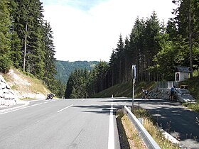
Sölk Pass is a high mountain pass in the Austrian Alps in the Bundesland of Styria.

Greifenburg is a market town in the district of Spittal an der Drau in the Austrian state of Carinthia.

Weissensee is a municipality in the district of Spittal an der Drau in Carinthia, Austria.

Biberwier is a municipality with 612 inhabitants in the district of Reutte in the Austrian state of Tyrol. The municipality is located in the district court Reutte.

The Allgäu Alps are a mountain range in the Northern Limestone Alps, located on the Austria–Germany border, which covers parts of the German states of Bavaria and Baden-Württemberg and the Austrian states of Tyrol and Vorarlberg. The range lies directly east of Lake Constance.

Macomb Mountain is a mountain in the Dix Range of the Adirondacks in the U.S. state of New York. It is the 21st-highest of the Adirondack High Peaks, with an elevation of 4,405 feet (1,343 m), and the most southeasterly of the High Peaks. It is located in the town of North Hudson in Essex County. The mountain is named for Alexander Macomb, an American general who became famous for his victory at the Battle of Plattsburgh in 1814. The name first appeared in print in 1842. The earliest recorded ascent of the mountain was made in 1872 by guide Mel Trumbull and artist Arthur H. Wyant.

Günter Litfin was a German tailor who became the second known person to die at the Berlin Wall. Litfin was the first victim to be killed by East German border troops, the first to succumb to gunshot wounds, and was the first male victim.

The Weissensee is a lake in the Austrian state of Carinthia within the Gailtal Alps mountain range. The highest situated Carinthian bathing lake shares its name with the municipality of Weissensee on the northern and southern shore.

The Gailtal Alps, is a mountain range of the Southern Limestone Alps in Austria. It rises between the River Drava (Drau) and the Gail valley and through the southern part of East Tyrol. Its western group called "Lienz Dolomites", is sometimes counted as part of this range and sometimes seen as separate.

National Highway 1 in India runs between the union territories of Jammu & Kashmir and Ladakh. It comprises parts of old NH1A and NH1D. The number 1 indicates, under the new numbering system, that it is the northernmost East-West highway in India.