
The Albula Alps are a mountain range in the Alps of eastern Switzerland. They are considered to be part of the Central Eastern Alps, more specifically the Western Rhaetian Alps. They are named after the river Albula. According to AVE, the Albula Alps are separated from the Oberhalbstein Alps in the west by the Septimer Pass and the valley of the Sursés; from the Plessur Alps in the north-west by the Landwasser valley; from the Silvretta group in the north-east by the Flüela Pass; from the Sesvenna Alps in the east by the Inn valley (Engadine); from the Livigno Alps in the south-east by the Inn valley; from the Bernina Range in the south by the Maloja Pass and the Inn valley.
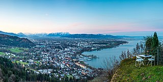
Bregenz is the capital of Vorarlberg, the westernmost state of Austria. The city lies on the east and southeast shores of Lake Constance, the third-largest freshwater lake in Central Europe, between Switzerland in the west and Germany in the northwest.
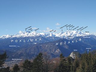
The Julian Alps are a mountain range of the Southern Limestone Alps that stretch from northeastern Italy to Slovenia, where they rise to 2,864 m at Mount Triglav, the highest peak in Slovenia. A large part of the Julian Alps is included in Triglav National Park. The second highest peak of the range, the 2,755 m high Jôf di Montasio, lies in Italy.

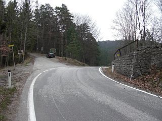
A mountain pass is a navigable route through a mountain range or over a ridge. Since mountain ranges can present formidable barriers to travel, passes have played a key role in trade, war, and both human and animal migration throughout history. At lower elevations it may be called a hill pass. A mountain pass is typically formed between two volcanic peaks or created by erosion from water or wind.

Trail Ridge Road is the name for the 48-mile (77 km) stretch of U.S. Highway 34 that traverses Rocky Mountain National Park from Estes Park, Colorado in the east to Grand Lake, Colorado in the west. Together with the connecting 6.9-mile (11 km) Beaver Meadow Road, Trail Ridge Road forms the 55-mile (89 km) Trail Ridge Road/Beaver Meadow National Scenic Byway, an All-American Road. With a high point at 12,183 feet (3,713 m) elevation, Trail Ridge Road is the highest continuous paved road in North America. The higher portion of Trail Ridge Road is closed from October to May.
The State Scenic Highway System in the U.S. state of California is a list of highways, mainly state highways, that have been designated by the California Department of Transportation (Caltrans) as scenic highways. They are marked by the state flower, a California poppy, inside either a rectangle for state-maintained highways or a pentagon for county highways.

Timmelsjoch, is a high mountain pass that creates a link through the Ötztal Alps along the border between Austria and Italy.

Argis is a commune in the Ain department in the Auvergne-Rhône-Alpes region of eastern France.

Ladakh is an administrative territory of India that has been under its control since 1947. The geographical region of Ladakh union territory is the highest altitude plateau region in India, incorporating parts of the Himalayan and Karakoram mountain ranges and the upper Indus River and valley.

Flexen Pass is a high mountain pass in the Austrian Alps in the Bundesland of Vorarlberg. It is at an elevation of 1,773 metres (5,817 ft).
Gerichtsberg Pass is a low mountain pass near to Hainfeld in the Austrian Alps in the Bundesland of Lower Austria.
The Kernhofer Gscheid Pass is a high mountain pass in the Austrian Alps in the Bundesland of Lower Austria.
Hals Pass is a low mountain pass in the Austrian Alps in the Bundesland of Lower Austria.

Hochtann Mountain Pass is a mountain pass in the Austrian Alps in the Bundesland of Vorarlberg.

The Allgäu Alps are a mountain range in the Northern Limestone Alps, located in Bavaria and Baden-Württemberg in Germany and Tyrol and Vorarlberg in Austria. The range lies directly east of Lake Constance.

Santa Susana Pass State Historic Park is a California State Park of 670.68 acres (2.7141 km2) located in the city of Los Angeles, in Los Angeles County on the boundary between Ventura and Los Angeles counties, between the communities of Chatsworth and Simi Valley. Geologically, the park is located where the Simi Hills meet the Santa Susana Mountains. Here in the western part of the Transverse Ranges, the land is dominated by high, narrow ridges and deep canyons covered with an abundant variety of plant life. The park offers panoramic views of the rugged natural landscape as a striking contrast to the developed communities nearby. The park is also rich in archaeological, historical, and cultural significance.
The Kerschbaum Saddle is a 1,111 m (AA) high mountain pass between Alpbachtal and Zillertal in the Austrian federal state of Tyrol.

The Lechquellen Mountains or Lechquellen range is a small mountain group within the Northern Limestone Alps of the Eastern Alps. It lies entirely within the Austrian state of Vorarlberg and includes the upper reaches of the river Lech with its headstreams in a horseshoe shape as well as the Upper Großwalsertal valley.

Ou Kaapse Weg, numbered as route M64, is a mountain pass in the Cape Peninsula that connects the Southern Suburbs of Cape Town with the Fish Hoek Valley. It traverses the Steenberg mountains and passes through the Silvermine Nature Reserve. Ou Kaapse Weg is one of three routes to the Fish Hoek Valley: the others are Chapman's Peak Drive along the Atlantic coast and Main Road along the False Bay coast.

National Highway 3, or NH 3, is a national highway in India. It starts from Atari adjacent to India-Pakistan border and near Amritsar and terminates at Leh in Ladakh, via Manali in Himachal Pradesh.


