
Carinthia, also Slovene Carinthia or Slovenian Carinthia, is a traditional region in northern Slovenia. The term refers to the small southeasternmost area of the former Duchy of Carinthia, which after World War I was allocated to the State of Slovenes, Croats and Serbs according to the 1919 Treaty of Saint-Germain. It has no distinct centre, but a local centre in each of the three central river valleys among the heavily forested mountains.

The Carinthian plebiscite was held on 10 October 1920 in the area in southern Carinthia predominantly settled by Carinthian Slovenes. It determined the final border between the Republic of Austria and the newly formed Kingdom of Serbs, Croats and Slovenes (Yugoslavia) after World War I. The predominantly Slovene-speaking plebiscite area voted to remain part of Austria with a 59% majority.

The Karawanks or Karavankas or Karavanks are a mountain range of the Southern Limestone Alps on the border between Slovenia to the south and Austria to the north. With a total length of 120 kilometres (75 mi) in an east–west direction, the Karawanks chain is one of the longest ranges in Europe. It is traversed by important trade routes and has a great tourist significance. Geographically and geologically, it is divided into the higher Western Karawanks and the lower-lying Eastern Karawanks. It is traversed by the Periadriatic Seam, separating the Apulian tectonic plate from the Eurasian Plate.
The Kamnik–Savinja Alps are a mountain range of the Southern Limestone Alps. They lie in northern Slovenia, except for the northernmost part, which lies in Austria.

The High Tauern are a mountain range on the main chain of the Central Eastern Alps, comprising the highest peaks east of the Brenner Pass. The crest forms the southern border of the Austrian states of Salzburg, Carinthia and East Tyrol, with a small part in the southwest belongs to the Italian province of South Tyrol. The range includes Austria's highest mountain, the Grossglockner at 3,798 metres (12,461 ft) above the Adriatic.

The Eastern Alps are usually defined as the area east of a line from Lake Constance and the Alpine Rhine valley, up to the Splügen Pass at the Alpine divide, and down the Liro River to Lake Como in the south. The peaks and mountain passes are lower than the Western Alps, while the range itself is broader and less arched.

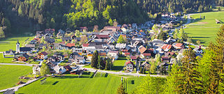
Tržič is a town in northern Slovenia, close to the Austrian border. It is the seat of the Municipality of Tržič.

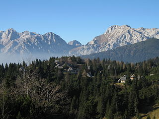
Seeberg Saddle, also just Seeberg (Jezersko) is a high mountain pass connecting Bad Eisenkappel in the Austrian state of Carinthia with Jezersko in the Slovenian region of Carinthia. It is located in the Southern Limestone Alps, between the Karawanks range in the west and the Kamnik–Savinja Alps in the east.

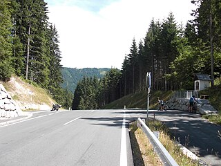
The Loibl Pass or Ljubelj Pass is a high mountain pass in the Karawanks chain of the Southern Limestone Alps, linking Austria with Slovenia. The Loibl Pass road is the shortest connection between the Carinthian town of Ferlach and Tržič in Upper Carniola and part of the European route E652 from Klagenfurt to Naklo.

Ferlach in the district of Klagenfurt-Land in Carinthia is the southernmost town in Austria. It is known for its centuries-old gunsmith tradition, part of the Austrian intangible cultural heritage since 2010.

European route E 59 is a north-south Class-A intermediate European route. It begins in Prague, Czech Republic, passes through Vienna, Austria and Maribor, Slovenia, ending near Zagreb, Croatia. The total length of the route is 644 km (400 mi). The E59 largely consists of motorways but some sections are developed either as expressways or two-lane roads with at-grade intersections. The motorway sections are generally tolled through varying systems and rates. Individual segments of the E59 route are shared with several other European routes. Originally, the route extended through Bihać, Bosnia and Herzegovina to Split, Croatia.

The Karawanks Tunnel is a motorway tunnel crossing the Alpine Karawanks mountain range between Austria and Slovenia, with a total length of 7.864 km, 8.019 km enclosure between the portals. Its construction began in 1986 and it opened on 1 June 1991. It connects the Austrian Karawanken Autobahn (A11) from Villach with the A2 motorway leading to Kranj and Ljubljana in Slovenia, decongesting the historic Loibl/Ljubelj and Wurzen/Korensko sedlo mountain passes.

Katschberg Pass is a high mountain pass in the Central Eastern Alps in Austria between Rennweg am Katschberg in the state of Carinthia and Sankt Michael im Lungau in Salzburg.
Kreuzberg Saddle is a high mountain pass across the Gailtal Alps in the Austrian state of Carinthia.

Plöcken Pass is a high mountain pass in the Carnic Alps mountain range at the border between the Austrian state of Carinthia and the Friuli-Venezia Giulia region of Italy. It links the market town of Kötschach-Mauthen in the Carinthian Gail Valley with the Paluzza municipality in the Carnia region of Friuli.

The Predil Pass or Predel Pass is a high mountain pass on the border between Italy and Slovenia.
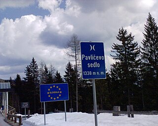
The Pavlič Pass, Paulitsch Pass or Paulitsch Saddle or just Pavlič is a mountain pass that connects the Slovenian municipality of Solčava in the historical region of Lower Styria with the Austrian state of Carinthia.

The Karawanks Tunnel is the fourth longest railway tunnel in Austria and the longest in Slovenia with a length of 7,976 metres (26,168 ft). It passes under Rožca Saddle between Rosenbach in southern Austria and Jesenice in northern Slovenia.
Podkoren is a settlement in the Municipality of Kranjska Gora in the northwestern Upper Carniola region of Slovenia.

The A2 motorway is a motorway in Slovenia, around 180 km long, connecting the Karawanks Tunnel via the capital city Ljubljana to Obrežje. It connects several major Slovene cities, including Kranj, Ljubljana, and Novo Mesto, and is part of Pan-European Corridor X.


