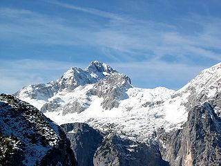
Triglav National Park (TNP) is the only national park in Slovenia. It was established in its modern form in 1981 and is located in the northwestern part of the country, respectively the southeastern part of the Alpine massif. Mount Triglav, the highest peak of the Julian Alps, stands almost in the middle of the national park. From it the valleys spread out radially, supplying water to two large river systems with their sources in the Julian Alps: the Soča and the Sava, flowing to the Adriatic and Black Sea, respectively.
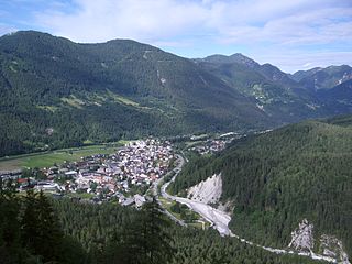
Kranjska Gora is a town in northwestern Slovenia, on the Sava Dolinka River in the Upper Carniola region, close to the Austrian and Italian borders. It is the seat of the Municipality of Kranjska Gora. The tripoint between Austria, Italy and Slovenia lies on the mountain of Dreiländereck, known as Peč in Slovenia.

The Sava is a river in Central and Southeast Europe, a right-bank and the longest tributary of the Danube. It flows through Slovenia, Croatia and along its border with Bosnia and Herzegovina, and finally through Serbia, feeding into the Danube in its capital, Belgrade. The Sava forms the main northern limit of the Balkan Peninsula, and the southern edge of the Pannonian Plain.

The Žumberak Mountains is a range of hills and mountains in northwestern Croatia and southeastern Slovenia, extending from the southwest to the northeast between the Krka and the Kupa.
The Hula Valley is an agricultural region in northern Israel with abundant fresh water, which used to be Lake Hula, prior to its draining. It is a major stopover for birds migrating along the Syrian-African Rift Valley between Africa, Europe, and Asia.
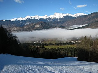
Bohinj, or the Bohinj Valley or Bohinj Basin, is a 20 km long and 5 km wide basin in the Julian Alps, in the Upper Carniola region of northwestern Slovenia. It is traversed by the Sava Bohinjka river. Its main feature is the periglacial Lake Bohinj. Bohinj is part of the Municipality of Bohinj, the seat of which is Bohinjska Bistrica.

The Sava Dolinka is a headwater of the Sava River in northwestern Slovenia. The 45 kilometres (28 mi) long Sava Dolinka starts as Nadiža Creek in the Planica Valley under Mount Zadnja Ponca in the Julian Alps, at an elevation of 1222 m, close to the Italian border. The stream goes underground soon after its source and breaks out again after 5 km at an elevation of 842 m in Zelenci, near Kranjska Gora. The Sava Dolinka flows through Kranjska Gora, Gozd Martuljek, Jesenice, between Bled and Breg, and past the town of Lesce. The first in a series of hydroelectric power plants on the river, the Moste Hydro Power Plant, is located near Žirovnica. It merges with the second major headwater of the Sava, the Sava Bohinjka, at Radovljica. Tributaries of the Sava Dolinka include the Triglav Bistrica at Mojstrana and the Radovna, which flows through the Vintgar Gorge near Bled.
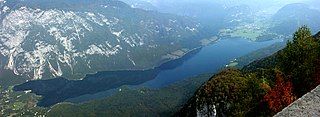
Lake Bohinj, covering 318 hectares, is the largest permanent lake in Slovenia. It is located within the Bohinj Valley of the Julian Alps, in the northwestern Upper Carniola region, and part of Triglav National Park.
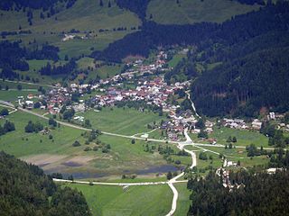
Rateče is a village in the Municipality of Kranjska Gora, in the far northwest corner of Slovenia. It is located in the upper part of the Upper Sava Valley, between the Sava Dolinka and Ziljica rivers, a tributary of the Drava. Further up the valley is the Rateče border crossing to Italy. Rateče is the closest Slovenian village to the summit of Mount Peč, the point where the borders of Austria, Italy, and Slovenia meet.

The Zasavica is a bog in the region of Mačva, west central Serbia. It is a major wildlife refuge and one of the last authentically preserved wetlands in Serbia. In the 2000s it became a popular attraction with the successful reintroduction of beavers, which had become extinct on the same land areas 100 years before.
Gornje Podunavlje Special Nature Reserve is a large protected area of wetland in the northwest of Serbia, on the Danube's left bank. It comprises two large marshes, Monoštorski Rit and Apatinski Rit and vast forests, meadows, ponds, swamps and the Danube's meanders, including 66 km (41 mi) of the Danube course. It is a part of the trans-boundary biosphere reserve "Mura-Drava-Danube", a five country project, dubbed the "Amazon of Europe".

The Sava Bohinjka is a headwater of the Sava River in northwestern Slovenia. At 41 kilometres (25 mi) in length, it is the shorter of the two headwaters that become the Sava River in Radovljica, the other being the 45 km (28 mi)-long Sava Dolinka.
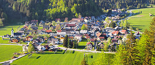
Podkoren is a settlement in the Municipality of Kranjska Gora in the northwestern Upper Carniola region of Slovenia.

The Nadiža is a mountain stream near the town of Kranjska Gora, in the far northwestern corner of Slovenia. Springing from a bare rockface on the eastern slope of Mount Zadnja Ponca above the Tamar Valley in the Julian Alps, it is the first source of the Sava Dolinka River, the longer of the two sources of the Sava, the longest Slovene river at 221 km (137 mi) and a tributary of the Danube.

The Radolfzeller Aach is a right or north tributary of the Rhine in the south of Baden-Württemberg (Germany). It is approximately 32 km long.

Fusine in Valromana is a frazione of the comune of Tarvisio in the Province of Udine, in the autonomous Friuli-Venezia Giulia region of northeastern Italy.

The Račna Karst Field is a karst field in the northern edge of the Lower Carniolan karst area, south of Grosuplje, Slovenia. It has rich natural and cultural value. Because of its ecological significance, it is anticipated that a nature park will be established there and that it will be included in the Natura 2000 program.

Savica Falls is a waterfall in northwestern Slovenia. It is 78 meters (256 ft) high and is fed by a karst spring also called Savica just above the waterfall.


