Trout is a generic common name for numerous species of carnivorous freshwater ray-finned fishes belonging to the genera Oncorhynchus, Salmo and Salvelinus, all of which are members of the subfamily Salmoninae in the family Salmonidae. The word trout is also used for some similar-shaped but non-salmonid fish, such as the spotted seatrout/speckled trout.
The National Fish Hatchery System (NFHS) was established by the U.S. Congress in 1871 through the creation of a U.S. Commissioner for Fish and Fisheries. This system of fish hatcheries is now administered by the Fisheries Program of the U.S. Fish and Wildlife Service (Service), an agency within the United States Department of the Interior.

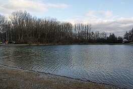
The Little Spokane River is a major tributary of the Spokane River, approximately 35 miles (56 km) long, in eastern Washington in the United States. It drains a rural area of forested foothills and a farming valley north of the city of Spokane along the Idaho–Washington border. It has two branches, one starting west of Newport and the other stemming from Eloika lake farther west.
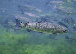
The rainbow trout is a species of trout native to cold-water tributaries of the Pacific Ocean in Asia and North America. The steelhead is an anadromous (sea-run) form of the coastal rainbow trout(O. m. irideus) or Columbia River redband trout (O. m. gairdneri) that usually returns to freshwater to spawn after living two to three years in the ocean. Freshwater forms that have been introduced into the Great Lakes and migrate into tributaries to spawn are also called steelhead.
Steelhead, or occasionally steelhead trout, is the common name of the anadromous form of the coastal rainbow trout (Oncorhynchus mykiss irideus) or Columbia River redband trout. Steelhead are native to cold-water tributaries of the Pacific basin in Northeast Asia and North America. Like other sea-run (anadromous) trout and salmon, steelhead spawn in freshwater, smolts migrate to the ocean to forage for several years and adults return to their natal streams to spawn. Steelhead are iteroparous, although survival is approximately 10–20%.

Donner Lake, formerly known as Truckee Lake, is a freshwater lake in Northeast California on the eastern slope of the Sierra Nevada and about 20 miles (32 km) northwest of the much larger Lake Tahoe. A moraine serves as a natural dam for the lake. The lake is located in the town of Truckee, between Interstate 80 to the north and Schallenberger Ridge to the south. The tracks of the Union Pacific Railroad run along Schallenberger Ridge and closely follow the route of the original transcontinental railroad. The historic route of the Lincoln Highway, the first automobile road across America and US 40 follows the northern shoreline, then climbs to Donner Pass from where the entire lake may be viewed.

Bundesautobahn 8 is an autobahn in southern Germany that runs 497 km (309 mi) from the Luxembourg A13 motorway at Schengen via Neunkirchen, Pirmasens, Karlsruhe, Pforzheim, Stuttgart, Ulm, Augsburg and Munich to the Austrian West Autobahn near Salzburg.

Oncorhynchus is a genus of fish in the family Salmonidae; it contains the Pacific salmon and Pacific trout. The name of the genus is derived from the Greek ὄγκος + ῥύγχος, in reference to the hooked snout that the males develop during mating season.
Newfound Lake is located in Grafton County, New Hampshire, United States. It is situated in the Lakes Region of central New Hampshire, in the towns of Alexandria, Bridgewater, Bristol, and Hebron. Its area of 4,451 acres (18.0 km2) places it behind only Lake Winnipesaukee and Squam Lake among lakes located entirely within New Hampshire, and fourth in the state overall, when Umbagog Lake on the Maine border is included.


Lake Diefenbaker is a reservoir and bifurcation lake in southern part of the Canadian province of Saskatchewan. It was formed by the construction of Gardiner Dam and the Qu'Appelle River Dam across the South Saskatchewan and Qu'Appelle Rivers respectively. Construction began in 1959 and the lake was filled in 1967. The lake is 225 kilometres (140 mi) long with approximately 800 kilometres (500 mi) of shoreline. It has a maximum depth of 66 metres (217 ft), while the water levels regularly fluctuate 3–9 metres (9–27 feet) each year. Lake Diefenbaker provides water for domestic irrigation and town water supplies. The flow of the two rivers is now regulated with a considerable portion of the South Saskatchewan diverted into the Qu'Appelle. Prior to the dams' construction, high water levels in the South Saskatchewan would frequently cause dangerous ice conditions downstream in Saskatoon while the Qu'Appelle would frequently dry up in the summer months.
Little Sunapee Lake is a 486-acre (197 ha) water body located primarily in Merrimack County in central New Hampshire, United States, in the town of New London. A small portion of the lake crosses into neighboring Springfield in Sullivan County. The lake is sometimes referred to as "Twin Lakes" due to a long, narrow peninsula which nearly cuts the lake in half. Water flowing out of the lake passes through Goose Pond and Otter Pond before entering Lake Sunapee. Bucklin Beach is a Town of New London recreation area at the east end of the lake.
Ohio currently has 5 rivers that host populations of either rainbow trout, brown trout, or brook trout. These rivers are the Mad River, the Clear Fork River, Clear Creek, the Chagrin River, and the Rocky River.
Lake Perris is an artificial lake completed in 1973. It is the southern terminus of the California State Water Project, situated in a mountain-rimmed valley between Moreno Valley and Perris, in what is now the Lake Perris State Recreation Area. The park offers a variety of recreational activities. Because of this and the lake's proximity to major population centers, it is very crowded during the summer months.

Freshwater fish are those that spend some or all of their lives in fresh water, such as rivers and lakes, with a salinity of less than 1.05%. These environments differ from marine conditions in many ways, especially the difference in levels of salinity. To survive fresh water, the fish need a range of physiological adaptations.

The Los Gatos Creek runs 24 miles (39 km) in California through Santa Clara Valley Water District's Guadalupe Watershed from the Santa Cruz Mountains northward through the Santa Clara Valley until its confluence with the Guadalupe River in downtown San Jose. The Guadalupe River then continues onward into San Francisco Bay.

The Beardslee trout, formerly Salmo gairdneri beardsleei) is a local form of rainbow trout endemic to Lake Crescent in Washington. Some sources treat them as a subspecies.

Wildcat Creek is a 13.4-mile-long (21.6 km) creek which flows through Wildcat Canyon situated between the Berkeley Hills and the San Pablo Ridge, emptying into San Pablo Bay in Contra Costa County, northern California.

The Golden Trout Wilderness is a federally designated wilderness area in the Sierra Nevada, in Tulare County and Inyo County, California. It is located 40 miles (64 km) east of Porterville within Inyo National Forest and Sequoia National Forest.

Lake Bob Sandlin State Park is a state park in Titus County, Texas managed by the Texas Parks and Wildlife Department. The park covers 639.8 acres of land on the northern shore Lake Bob Sandlin about 10 miles southwest of Mount Pleasant.