
New York State Route 5 (NY 5) is a state highway that extends for 370.80 miles (596.74 km) across the state of New York in the United States. It begins at the Pennsylvania state line in the Chautauqua County town of Ripley and passes through Buffalo, Syracuse, Utica, Schenectady, and several other smaller cities and communities on its way to downtown Albany in Albany County, where it terminates at U.S. Route 9 (US 9), here routed along the service roads for Interstate 787 (I-787). Prior to the construction of the New York State Thruway, it was one of two main east–west highways traversing upstate New York, the other being US 20. West of New York, NY 5 continues as Pennsylvania Route 5 (PA 5) to Erie.

An automotive navigation system is part of the automobile controls or a third party add-on used to find direction in an automobile. It typically uses a satellite navigation device to get its position data which is then correlated to a position on a road. When directions are needed routing can be calculated. On the fly traffic information can be used to adjust the route.

New York State Route 13 (NY 13) is a state highway that runs mainly north–south for 152.30 miles (245.10 km) between NY 14 in Horseheads and NY 3 west of Pulaski in Central New York in the United States. In between, NY 13 intersects with Interstate 81 (I-81) in Cortland and Pulaski and meets the New York State Thruway (I-90) in Canastota. NY 13 is co-signed with several routes along its routing, most notably NY 34 and NY 96 between Newfield and Ithaca; NY 80 between DeRuyter and Cazenovia; and NY 5 between Chittenango and Canastota.
New York State Route 7 (NY 7) is a 180.30-mile-long (290.16 km) state highway in New York in the United States. The highway runs from Pennsylvania Route 29 (PA 29) at the Pennsylvania state line south of Binghamton to Vermont Route 9 (VT 9) the Vermont state line east of Hoosick. Most of the road runs along the Susquehanna Valley, closely paralleling Interstate 88 (I-88) throughout that road's length. Portions of the highway route near the cities of Binghamton, Schenectady, and Troy date back to the early 19th century.

New York State Route 34 (NY 34) is a north–south New York state route located in Central New York. Its southern terminus is at the Pennsylvania state line in the village of Waverly, where it connects to Pennsylvania Route 199 and meets I-86/NY 17. Its northern terminus is at NY 104, outside the village of Hannibal.

New York State Route 48 (NY 48) is a 28.20-mile (45.38 km) north–south state highway in Central New York in the United States. The southern terminus of the route is located at Interstate 690 (I-690) exit 3 near the interchange between I-690 and the New York State Thruway (I-90) in Van Buren, northwest of Syracuse. The northern terminus is located at an intersection with NY 104 in Oswego. In between, NY 48 passes through the riverside communities of Baldwinsville and Fulton and runs alongside both the Seneca River and Oswego River. For most of its route, NY 48 serves as an alternate route of NY 481. The routes share similar alignments along the Oswego River from the Syracuse area to Oswego, with NY 481 following the eastern riverbank between the two locations.

New York State Route 210 (NY 210) is a state highway in Orange County, New York, in the United States. It runs north from the New Jersey state line—where it continues south as Passaic County Route 511 (CR 511)—along the west shore of Greenwood Lake to the eponymous village of Greenwood Lake, where it ends at a junction with NY 17A. It was once much longer, as it originally extended east along NY 17A and CR 106 in Orange and Rockland counties to Stony Point when it was assigned as part of the 1930 renumbering of state highways in New York. The route was truncated to its current length in 1982. Prior to becoming NY 210 in 1930, the road alongside Greenwood Lake was part of NY 55, a route connecting New Jersey to Goshen, in the 1920s.

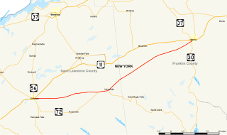
New York State Route 146 (NY 146) is a state highway in the Capital District of New York in the United States. It extends for 43 miles (69 km) from Gallupville at NY 443 to near Mechanicville at U.S. Route 4 (US 4) and NY 32. NY 146 is a major thoroughfare in the city of Schenectady, just outside Albany. Most of the route follows an east–west alignment; however, the middle third of the route between Guilderland and Clifton Park runs in a more north–south manner in order to serve Schenectady. At one time, NY 146 had three spur routes; only one—NY 146A—still exists.

New York State Route 82 (NY 82) is a state highway in the eastern Hudson Valley of New York in the United States. It begins at an intersection with NY 52 northeast of the village of Fishkill, bends eastward towards Millbrook, and then returns westward to end at a junction with U.S. Route 9, NY 9H, and NY 23 at Bell Pond, near Claverack. NY 82 meets the Taconic State Parkway twice; it is the only state highway that has more than one exit with the parkway. The road spans two counties: Dutchess and Columbia.
New York State Route 343 (NY 343) is a state highway located entirely within central Dutchess County, in the Hudson Valley region of the U.S. state of New York. It runs east–west from the intersection of NY 82 in the village of Millbrook to the town of Amenia, where it crosses the Connecticut state line and continues eastward as Route 343, a Connecticut state highway located in the town of Sharon. Along the way, it has a 7.3-mile (11.7 km) concurrency with NY 22 from vicinity of the hamlet of Dover Plains to the hamlet of Amenia.

New York State Route 21 (NY 21) is a state highway extending for 99.99 miles (160.92 km) through the western part of New York in the United States. The southern terminus of the route is at an intersection with NY 417 in the village of Andover, and its northern terminus is at a junction with NY 104 in the town of Williamson. In between, NY 21 serves the cities of Hornell and Canandaigua and intersects several major east–west routes, including the Southern Tier Expressway near Hornell, the conjoined routes of U.S. Route 20 (US 20) and NY 5 in Canandaigua, the New York State Thruway (I-90) in Manchester, and NY 31 in Palmyra.

New York State Route 92 (NY 92) is a state highway located in central New York in the United States. The western terminus of the route is at an intersection with U.S. Route 11 in downtown Syracuse. Its eastern terminus is at a junction with US 20 west of the village of Cazenovia. NY 92 is known as East Genesee Street through Syracuse and DeWitt; from DeWitt to Cazenovia, its name varies by location. It heads generally eastward through Syracuse to DeWitt, where it crosses Interstate 481 (I-481) while concurrent with NY 5. At the east end of the overlap, it splits off follows a more southeasterly routing through the village of Manlius to Cazenovia.
New York State Route 326 (NY 326) is a 8.74-mile-long (14.07 km) state highway in Cayuga County, New York, in the United States. NY 326 runs in a southwest to northeast direction from the village of Union Springs to the city of Auburn. The western terminus of the route is at an intersection with NY 90 near the northern village line of Union Springs. Its eastern terminus is at a junction with U.S. Route 20 (US 20) and NY 5 just west of the Auburn city limits in the town of Aurelius. NY 326 passes through largely rural portions of the Finger Lakes region and does not pass through any built-up areas other than those at each of its termini.
Magellan Navigation, Inc. is an American producer of consumer and professional grade global positioning system receivers, named after Ferdinand Magellan, the first explorer to circumnavigate the globe. Headquartered in San Dimas, California, with European sales and engineering centers in Nantes, France and Moscow, Russia, Magellan also produces aftermarket automotive GPS units, including the Hertz Neverlost system found in Hertz rental cars. The Maestro, RoadMate, Triton, and eXplorist lines are Magellan's current consumer offerings. The company also produces proprietary road maps (DirectRoute), topographic maps (Topo), and marine charts (BlueNav) for use with its consumer GPS receivers.

New York State Route 69 (NY 69) is a state highway extending for 57.42 miles (92.41 km) across the central portion of the U.S. state of New York. The western terminus of the route is at NY 104 in the Oswego County village of Mexico. The eastern terminus is at NY 5A in the Oneida County village of Yorkville, just west of Utica. In between, NY 69 serves the city of Rome.
New York State Route 11B (NY 11B) is a state highway in northern New York in the United States. It provides a parallel, more southerly east–west route to U.S. Route 11 between US 11 in Potsdam and US 11, NY 30, and NY 37 in Malone. NY 11B serves both the Potsdam Municipal Airport and the riverside hamlet of Nicholville, where NY 11B meets NY 458. Aside from the two villages at each end of the route and the hamlet of Nicholville near the midpoint, NY 11B passes through rural, lightly populated areas, as does its parent to the north. In Malone, NY 11B overlaps NY 30 for one block in order to reconnect to US 11.
U.S. Route 4 (US 4) is a part of the U.S. Highway System that runs from East Greenbush, New York, to Portsmouth, New Hampshire. In the U.S. state of New York, US 4 extends 79.67 miles (128.22 km) from an intersection with US 9 and US 20 in East Greenbush to the Vermont state line northeast of Whitehall. While the remainder of US 4 east of New York is an east–west route, US 4 in New York is signed north–south due to the alignment the route takes through the state. The portion of the route between Waterford and Whitehall is part of the Lakes to Locks Passage, an All-American Road.

A road map or route map is a map that primarily displays roads and transport links rather than natural geographical information. It is a type of navigational map that commonly includes political boundaries and labels, making it also a type of political map. In addition to roads and boundaries, road maps often include points of interest, such as prominent businesses or buildings, tourism sites, parks and recreational facilities, hotels and restaurants, as well as airports and train stations. A road map may also document non-automotive transit routes, although often these are found only on transit maps.

New York State Route 35 (NY 35) was a state highway in the Finger Lakes region of New York, in the United States. The western terminus of the route was at an intersection with NY 36 in the hamlet of Mumford within the town of Wheatland. Its eastern terminus was at a junction with U.S. Route 104 (US 104) in the hamlet of Ontario Center within the town of Ontario. NY 35 followed a mostly northeast–southwest routing across the counties of Monroe and Wayne and passed through downtown Rochester.


