Highway 156 is a designation for three east–west state highways in Washington County, Arkansas. The first segment was created in 1937, with two more created in 1973. All are minor state highways established to provide system connectivity and are maintained by the Arkansas Department of Transportation (ArDOT).

Highway 87 is a designation for four north–south state highways in Arkansas. Created during the 1926 Arkansas state highway numbering, the original alignment remains between Bradford and Pleasant Plains, though it has been revised and extended over the years. The three remaining segments are former county roads, connecting rural communities to local points of interest and other state highways. All three were added to the state highway system in 1973 during a period of system expansion. All segments are maintained by the Arkansas Department of Transportation (ArDOT).

Highway 463 is a north–south state highway in northeast Arkansas. The route of 20.59 miles (33.14 km) runs from Highway 14 very near I-555 at Payneway north to I-555/US 63B in Jonesboro. The route is a redesignation of former U.S. Route 63, which has since been rerouted onto US 49.

Highway 355 is a designation for three north–south state highways in Southwest Arkansas. The routes are maintained by the Arkansas Department of Transportation (ArDOT).

Highway 77 is a north–south state highway in Northeast Arkansas. The route of 66.70 miles (107.34 km) runs from US Highway 70 (US 70) in West Memphis north through small towns and agricultural areas of the Arkansas Delta to the Missouri state line. It is generally a low-traffic road except in West Memphis. Created during the 1926 Arkansas state highway numbering, the route was extended in the 1950s and 1960s, including along a former alignment of US 61. AR 77 does not have any spur or business routes.

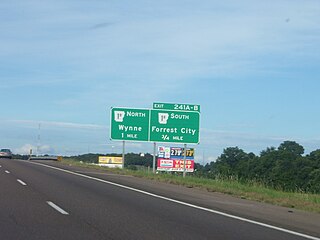
Highway 14 is an east–west state highway in Arkansas. The route of 227.35 miles (365.88 km) begins at Boat Dock Road near Table Rock Lake and runs east to Mississippi County Route W1020 (CR W1020) at Golden Lake. Segments of the highway are part of two Arkansas Scenic Byways: Sylamore Scenic Byway in the Ozark National Forest and the Crowley's Ridge Parkway atop Crowley's Ridge.
Arkansas Highway 119 is a series of state highways that run in Northeast Arkansas. All routes are maintained by the Arkansas Department of Transportation (ArDOT).

Highway 141 is designation for two north–south state highways in Northeast Arkansas. The longer segment was created in 1931 and extended throughout the mid-20th century to the current alignment connecting Jonesboro and points north. The Jonesboro segment was a former city street added to the state highway system in 1973. Both are maintained by the Arkansas Department of Transportation.

Highway 349 is a designation for two state highways in Northeast Arkansas. One route of 4.45 miles (7.16 km) begins at Highway 226 and runs north to Highway 18/Highway 91. A second route of 2.44 miles (3.93 km) begins at Highway 230 and runs north to Highway 228. Both routes are maintained by the Arkansas Department of Transportation (ArDOT).

Highway 18 is an east–west state highway of 93.43 miles (150.36 km) in Northeast Arkansas. It has concurrency with U.S. Route 78 (US 78) much of its length.
Highway 163 is a north–south state highway in Northeast Arkansas. The highway begins at Wittsburg and runs 42.57 miles (68.51 km) northeast to Highway 1, Highway 1 Business (AR 1B) and Crowley's Ridge Parkway (CRP) in Jonesboro. A spur route runs in Jonesboro. All routes are maintained by the Arkansas Department of Transportation (ArDOT). Almost all of the route is concurrent with Crowley's Ridge Parkway, with a portion also serving as an Arkansas Heritage Trail for its use during the Civil War.

Arkansas Highway 226 is a designation for two state highways in northeast Arkansas. The main segment of 25.28 miles (40.68 km) runs east from an intersection of AR 367 near Swifton to Interstate 555 (I-555)/U.S. Route 63 (US 63)/AR 18 in Jonesboro. Much of this route in the eastern segment is concurrent with US 78. A short route of 2.38 miles (3.83 km) runs in rural Jackson County west of Tuckerman.

Highway 308 is a designation for two east–west state highways in Northeast Arkansas. One segment runs east from AR 149 in Marked Tree to Spear Lake. A second route of 10.94 miles (17.61 km) begins at Highway 118 at Whitton and runs east to US 61 at Frenchman's Bayou. The highway also has a business route and spur route in Marked Tree. All four routes are maintained by the Arkansas Department of Transportation (ArDOT).

Highway 164 is a designation for four segments of state highway in the Arkansas River Valley. Each are low-volume local roads providing connectivity to small communities, or recreation areas near the Ozark National Forest. The first segment was created in 1945, with the remaining segments created during the late 1950s and 1960s, a period of major Arkansas Highway System expansion. A single spur route provides access to an industrial area in Clarksville. All routes are maintained by the Arkansas Department of Transportation (ArDOT).

Sixteen special routes of U.S. Route 62 currently exist. Seven of them lie within the state of Arkansas. Three existed in the past but have since been decommissioned.
Highway 247 is a designation for four north–south state highways in the Arkansas River Valley. Two are low traffic, two-lane, rural connector highways serving sparsely populated areas of the River Valley. A third segment is a four-lane divided highway bypassing Pottsville. A fourth segment mostly runs as Poor Farm Road in Morrilton among several educational buildings in the city. The first rural segment was created in 1957, with the Morrilton segment created in 1965 and a second rural segment in 1966. The final designation came in 1973. All segments are maintained by the Arkansas Department of Transportation (ArDOT).

Twelve special routes of U.S. Route 63 currently exist. Arkansas and Missouri each contain five, with two in Iowa. There are also five former routings that have been removed from the system.

Several special routes of U.S. Route 49 exist. In order from south to north they are as follows.
Six business routes of Arkansas Highway 1 currently exist, with one spur route. Each of the routes is a former alignment of Arkansas Highway 1, which is common practice.

Six auxiliary routes of Arkansas Highway 7 currently exist. Four are spur routes, one is a business route, and one is a truck route. They are listed below in south-to-north order.